2023-11-02
Imaging At Belva Crater: Why Craters Matter!
Contributed by Darian Dixon and Andreas Bechtold
Mars is a planet absolutely pockmarked with craters. Viewing imagery of Mars from just about any orbital scale will review a surface dominated with round depressions of various sizes. Some craters engulf entire regions, such as the 3,300 km (2,100 mi) wide Utopia crater, where Viking 2 landed in 1976. Some are minuscule in comparison, like the 10-20 cm (3.9-7.9 inch) mini craters found by the Opportunity rover in Meridiani Planum in 2005. Mars is not unique in this way. Mercury, the Moon, and many other bodies in our solar system are also dotted with impact craters of various size. This might lead you to ask: why isn’t the Earth the same way?
To understand why Mars is so rich in craters, you must understand Mars’ history and current conditions. Mars is barren, dry, and almost entirely lacking in the type of large-scale geologic activity that would bury its many ancient scars. We believe things have been this way for a very long time. Earth is a very active planet and almost always has been. We have plate tectonics, volcanic eruptions, landslides, glaciers, massive water bodies, and biological activity – which includes the global-scale landscape redecorating us humans have done over the years. All these processes can bury, erode, and erase impact craters. Mars has been far less active for most of its history, preserving many of its craters. And this is actually very beneficial for conducting science on Mars!
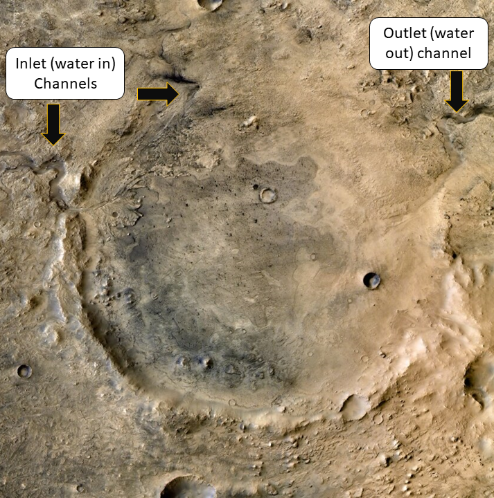
Craters are important in our efforts to explore Mars. Craters often house important geologic features indicative of past water. As Bill Nye once so eloquently put when discussing fluids, ‘it flows! It flows! It flows!’ Water on ancient Mars found topographic lows to flow to and settle in. Thus, many craters on Mars may have once been lakes where rivers carried water to and from. That’s an incredibly different world from the dry and dusty Mars we’ve grown used to. So, because many craters on Mars may have once housed significant and long-standing bodies of water, they represent some of the best places to look for peering into Mars’ wet past. Jezero Crater, with its two inlet channels, beautifully preserved river deltas, and outlet channel is postulated to have been one such crater lake environment. These features played a huge role in its selection as the landing site for Perseverance.
Annotated Mars Reconnaissance Orbiter image of Jezero Crater showing the channels that once delivered and removed water from the crater. (Image credit: NASA/JPL-Caltech)
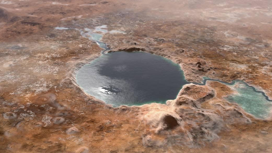
Depiction of what Jezero Crater may have looked like in the past when Mars was a more water-rich world. (Image credit: NASA/JPL-Caltech)
Craters also act as windows into the subsurface. The Law of Superposition is a geologic principle that the oldest layers of rocks are those that are at the bottom of any stratigraphic section of rock. As we descend from Mars’ surface, we are looking further and further back in time. Craters excise the surface and can sometimes reveal the layers and history below. So, it’s important we peer inside them when we can. Information like past climate conditions, modes of sediment transport, and past water chemistry can be gleaned by geologists when analyzing exposed layers of rock. It’s safe to say the study of martian craters has helped define our exploration of the Red Planet. All of our Mars rovers have explored the geology of impact craters both large and small.
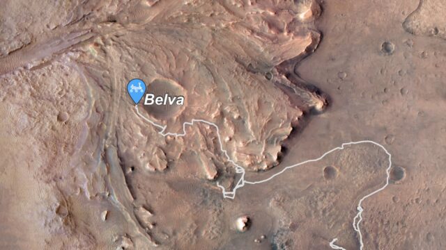
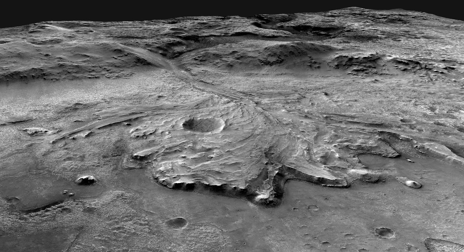
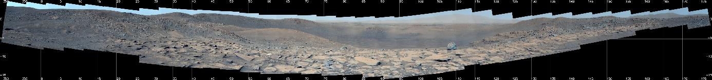
In the spring of 2023, Perseverance continued our crater quest when we parked on the western edge of Belva Crater. Belva Crater is a 0.9 km (0.6 mile) wide crater located on top of the western delta within Jezero Crater. Deltas are very interesting geologic features. The relationships, structures, and characteristics of the sediment layers that comprise a delta can provide all sorts of juicy details about the nature of the water body that formed it. To help scientists uncover more details about the sedimentary and stratigraphic history of Jezero Crater, Mastcam-Z acquired some outstanding imagery of Belva Crater’s interior and surroundings. This imagery included a 152-image stunning mosaic captured on Sol 772 (April 22nd, 2023).
Oblique view of the Jezero Crater western delta. Belva Crater (near the center of the image) is the largest crater on the western delta. (Image credit: NASA/MSSS/USGS)

Mastcam-Z sol 772 (April 22, 2023) mosaic of Belva crater. Left eye, enhanced color. See the mosaic page for more info and downloads! (Image credit: NASA/JPL-Caltech/ASU/MSSS)
Planning Belva Crater Mosaics in 3D!
Considering the value craters like Belva provide to our efforts to understand regional geology, we take great care in how we image them. The Mastcam-Z team doesn’t merely point and click on a whim. The planning process for our imagery is rigorous and detailed. So detailed that we exhaust loads of tools to ensure we get the product the Perseverance team will find most scientifically useful. Andreas Bechtold is a PhD student at the University of Vienna and one of our many Mastcam-Z science team members. Here he describes how a sophisticated 3D imaging tool was used for planning another Belva Crater mosaic captured on Sol 792 (May 13, 2023):
PRo3D (Planetary Robotics 3-D) is an interactive viewer for 3-D-visualizations and analysis (https://pro3d.space/). This software makes it possible to measure, for example, distances, heights, geometric relationships, and orientations of geological features using 3-D data processed from Mars rover stereo camera images. In combination with a Digital Terrain Model (DTM) from the HiRISE instrument aboard the Mars Reconaissance Orbiter, it is possible to use PRo3D as a view planner for Mastcam-Z and other Mars rover cameras. A DTM of the western part of Jezero crater was used to complement planning the Mastcam-Z imaging of Belva crater.
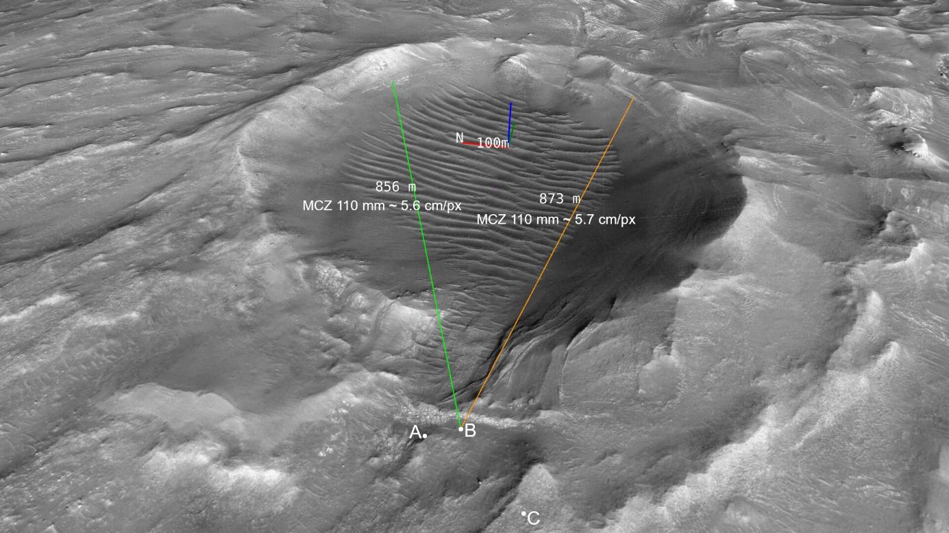
Overview image for orientation (see A, B, and C below) produced using a HiRISE Digital Terrain Model (DTM) shown with PRo3D. (Image credit: NASA/JPL-Caltech/ASU/MSSS/JR/VRVis/ÖAW)
Figure A shows the real Mastcam-Z 110 mm mosaic of Belva crater taken at a location near Echo creek on the western fan top in Jezero crater.
A – Mastcam-Z 110 mm enhanced color mosaic of Belva crater interior from sol 792. The gridlines you see in the image mark azimuth and elevation. In what’s referred to as the ‘Site frame’ coordinate system, 0° azimuth corresponds to due north and 180° azimuth to due south. Elevation typically ranges from -70° (lowest point) to +10° (highest point), providing context for the vertical component of the pointing of our mosaic. (Image credit: NASA/JPL-Caltech/ASU/MSSS)
For Figure B a virtual Mastcam-Z camera has been positioned at an alternative location near Echo Creek on the HiRISE DTM of Jezero crater with PRo3D. Using PRo3D’s Instrument View tool, nine simulated Mastcam-Z 110 mm images were captured and stitched together to create the mosaic in Figure B.
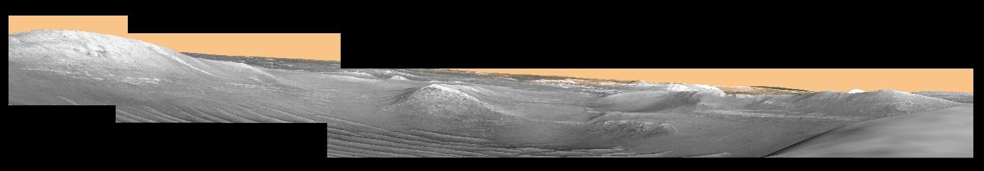
B – Simulated Mastcam-Z 110 mm mosaic of Belva crater from a position at Echo Creek. (Image credit: NASA/JPL-Caltech/ASU/MSSS/JR/VRVis/ÖAW)
The mosaic in Figure C has been simulated in the same way using 32 virtual Mastcam-Z images. Both simulated mosaics showed how a real Mastcam-Z mosaic from these specific locations would look, helping to find an optimal rover position for the imaging of Belva crater with the result shown in Figure A.
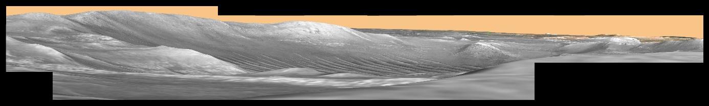
C – Simulated Mastcam-Z 110 mm mosaic from a position at Mt. Julian. Made from 32 frames taken with the PRo3D view planner ZCAM analogue camera on the HiRISE DTM. (Image credits: NASA/JPL-Caltech/ASU/MSSS/JR/VRVis/ÖAW)
The geology at Belva Crater is still actively being analyzed and discussed by mission scientists, but we’ve made some intriguing observations. The presence of exposed layers of steeply dipping bedrock have yielded clues about Jezero’s watery past – potentially being the remnants of an ancient sandbar, as noted in this official mission report. Mars being so heavily cratered is auspicious for our ongoing exploration. We need glimpses into the subsurface to get a more complete picture of Mars’ geologic history. Craters often do a great job of providing that. When we come across a geologically compelling crater, Mastcam-Z brings their A-game to deliver spectacular images.
________________________________________________________________________________________________________________
MEET A MARTIAN!

While Perseverance is always the star of the show, countless scientists and engineers are responsible for making her go and analyzing her data. Each of us have our own skills, backgrounds, and scientific goals but we all come together to do great work on Mars. Andreas Bechtold is one such team member. Andreas graciously answered a few questions so that you could meet a martian and learn more about one of our many great scientists.
What is your role on Mastcam-Z?
I am a PhD student at the University of Vienna (Austria) and a Mastcam-Z student collaborator for the Austrian Academy of Sciences. As a member of the Mars 2020 science team, I am involved in the Mastcam-Z Geology & Geomorphology working group and participate in the Mars 2020 science discussions. My expertise is mostly in meteorites, impact cratering, and petrology/geochemistry as well as 3-D visualization and analysis of planetary rover images. In the near future, I would also like to start working on the operations part of the mission.
What is your favorite part of exploring Mars?
Looking at the latest Mastcam-Z images and 3-D products trying to understand what they tell us about the area Perseverance is visiting on Mars (and maybe beyond) and hearing from other team members about their thoughts on it and the results from the other rover instruments.
What started you on your path to doing the exciting work you do today?
It was a long journey that probably started when I was a little child that collected rocks and crystals and wanted to become a volcanologist.
What are you most passionate about outside of your work?
My family and friends.
What advice do you have for students interested in a future planetary science career?
Follow your interests even if they don’t seem to be useful in the first place. Find the right institution to help you to grow in planetary science and find the people that can support you in doing so. Set your priorities accordingly as long as it makes sense for you and don’t give up, opportunities and ideas sometimes come if you least expect them.