Daniel Crouch Rare Books Ltd
4 Bury Street, St James’s London SW1Y 6AB
+44 (0)20 7042 0240
info@crouchrarebooks.com crouchrarebooks.com
Daniel Crouch Rare Books New York LLC
24 East 64th Street New York NY 10065
+1 (212) 602 1779
info@crouchrarebooks.com crouchrarebooks.com
Catalogue edited by Daniel Crouch, Mia Forbes, Kate Hunter, Elena Napoleone, Qi Sun and Nick Trimming
Design by Ivone Chao
Photography by Louie Fasciolo
Cover: item 7
Terms and conditions: The condition of all books has been described. Each item may be assumed to be in good condition, unless otherwise stated. Dimensions are given height by width. All prices are net and do not include postage and packing. Invoices will be rendered in £ sterling. The title of goods does not pass to the purchaser until the invoice is paid in full.
Printed by Park Communications on FSC® certified paper. Park is an EMAS certified company and its Environmental Management System is certified to ISO14001. 100% of the inks used are vegetable oil based, 95% of press chemicals are recycled for further use and, on average 99% of any waste associated with this production will be recycled. This document is printed on Galerie Matt made of material from wellmanaged, FSC®-certified forests and other controlled sources. The pulp used in this product is bleached without the use of chlorine (ECF).

Sic itur ad astra
APIANUS, Petrus
Astronomicum Caesareum.
Publication
Ingolstadt, Peter Apian, 1540.
Description
Folio (468 by 310mm). [59] ll. [plus one cancel, see below], COMPLETE. Title-page framed by a woodcut border, on verso of the same leaf woodcut coat of arms of joint the dedicatees Charles V and his brother Ferdinand of Spain. 53 elevenline and 39 six-line historiated woodcut initials by Hans Brosamer. 36 full-page woodcut astronomical figures coloured by a contemporary hand, of which 21 have a total of 83 volvelles [complete]. 24 have 43 (of 44) silk threads; and 11 (of 12) seed pearls, an additional black and white plate bound at rear. Full-page woodcut arms of the author by Michael Ostendorfer on fol. O6, a fine, unpressed copy in contemporary blind-stamped pigskin-backed wooden boards, spine covered in eighteenth century in sheep, preserved in a full morocco box.
References
Adams A, 1277; Schottenloher, Landshuter Buchdrucker, 42; Benezit II, 332; VIII, 49; Campbell Dodgson II, 242; DSB I, pp. 178-179; Lalande, p. 60; Gingerich, Rara Astronomica, 14; Stillwell, The Awakening Interest in Science during the First Century of Printing, 19; Van Ortroy, 112; Zinner 1734; D. J. de Solla Price, Science since Babylon, New Haven 1975, p. 104O. Gingerich, Apianus’s Astronomicum Caesareum, «Journal for the History of Astronomy», 2 (1971), pp. 168-177; E. Poulle, Les instruments de la théorie des planètes selon Ptolémée , Genève 1980, 1.83; O. Gingerich, A Survey of Apian’s Astronomicum Caesareum, in Peter Apian, ed. by Karl Röttel, Buxheim1995, p. 113.
$1,820,000.00
First edition of “the most luxurious and intrinsically beautiful scientific book that has ever been produced” (de Solla Price), in an extraordinary hand-coloured early issue, as attested by the letterpress cancel slip on fol. K1r, preserved in a beautiful contemporary German binding, with turned wood depressions to accommodate the volvelles on the inside of each board. The author of this popular textbook in astronomy is Petrus Apianus, astronomer and professor of mathematics at Ingolstadt, and a veritable pioneer in the production of astronomical and geographical devices.
Apianus’s work on the project began eight years before and the ‘Astronomicum Caesareum’, which was printed in his private press at Ingolstadt, is considered “the most spectacular contribution of the book-maker’s art to sixteenth-century science” (Gingerich, “Apianus’s Astronomicum Caesareum”).
The handbook is divided in two parts. The first (ll. B1-M3) includes 40 chapters with maps reproducing the position and the movement of celestial bodies. The second part describes the meteroscope, an instrument designed to solve problems in spherical trigonometry, and relates the sighting of five comets: “The Astronomicon is notable for Apian’s pioneer observations of comets (he describes the appearances and characteristics of five comets, including Halley’s) and his statement that comets point their tails away from the sun. Also important is his imaginative use of simple mechanical devices, particularly volvelles, to provide information on the position and movement of celestial bodies” (DSB).
The volvelles in the work are each placed within a frame reminiscent of an astrolabe, a contemporary device that modelled the movement of the heavens in two dimensions and enabled the calculation of time and place, and assisted with astrology. The first moveable woodcut, which represents the planispheric astrolabe, compresses both hemispheres onto one plate. According to the text, the plate depicts 1,033 stars, and was based on the first printed star charts published in 1515 by Albrecht Dürer.
The most spectacular of the volvelles, which are the work of the artist Michael Ostendorfer, are the dragon plates. These include the title-page and the double-page spread dragon and moon dials. The dragon dial can be used to calculate the nodes of the moon, the two points of intersection between the yearly path of the sun, and the plane of the lunar orbit, which produce eclipses. Dragons were associated with eclipses, which were believed to occur when their head or tail blocked the sun. The thirteen small dragons indicate different parts of the lunar cycle.
For the dissemination of calculating technology in a standardized and reproducible form, the appearance of “paper instruments” has been compared to nothing less than the advent of printing (Poulle).
Copies usually have far fewer volvelles than the present book, as for example the Honeyman copy, with 76. This example also has all but one of the sliding seed pearls (meant to be used as markers) which are
6 DANIEL CROUCH RARE BOOKS SIC ITUR AD ASTRA
1
“The most spectacular contribution of the bookmaker’s art to sixteenth-century science” from the library of Castle Wolfegg

almost always missing. The sheets are fresh, unpressed, and the volvelles tight and untorn; the double-page opening (verso of G3, recto G4) is in excellent state (the volvelles on G3 verso are usually torn away from opening as they are the only volvelles on a verso).

This copy has the following issue points: G4r has the text printed above the figure (i.e not on slips pasted on); K1r has correction slip pasted; the arms at the end are in the first (of three) states. In addition there is an unrecorded leaf signed ‘G3’, bound at the end. The full-page woodcut on the recto does not correspond to any in the book, while the text on the verso is a variant of that found on the recto of G3 and the verso of G4 in the book. This clearly was a trial setting that was cancelled. This copy has all of the threads apart from one on C3, and all of the pearls apart from one on G1; however it has an unrecorded pearl on B3. The turned wood depressions on the inner boards are apparently unique to the present example. Wood turning was a fashionable gentlemanly pursuit in early modern central Europe (as evidenced by the magnificent lathe from the collection of Maximilian I in the Bayerische Nationalmuseum), and the inset depressions in the covers are a splendid and practical to the problem presented by the thickness of the volvelles when binding copies of the Astronomicum.
“Some thirty-five copies of the Astronomicum Caesareum are known today. Fabulously expensive to produce and prohibitively expensive to buy, it was always a rare book. Nicholas Wotton reported in 1544 from the Diet of Speyer that Apian would give Henry VIII a copy, for otherwise the king would not be able to get hold of it; Edmund Halley tried in vain to obtain a copy” (Hebron).

8 DANIEL CROUCH RARE BOOKS SIC ITUR AD ASTRA


Provenance
Wolfegger Kabinett (The Library of Castle Wolfegg near Ulm), from the estate of the Princes Waldburg.
Schloss Wolfegg is a Renaissance castle and seat of the princely family of Waldburg-Wolfegg, which still owns it today.
The Wolfegger Kabinett is a large private collection of mostly German graphics from the fifteenth and sixteenth century. Among its most famous pieces were the Waldseemüller map, the Mittelalterliches Hausbuch and the Kleiner Klebeband, all of which were sold in the early twenty-first century.
The Waldseemüller map - the first map to name America, was published In April 1507 in an edition of 1,000 copies by the German cartographers Martin Waldseemüller and Matthias Ringmann. The only surviving example was discovered in an album in the Wolfegger Kabinett in 1901 by the historian and cartographer Joseph Fischer. The album was originally the property of Johannes Schöner (1477-1546), astronomer, geographer, and cartographer in the Free Imperial City of Nuremberg. Later the family of Waldburg-Wolfegg acquired the map and it remained in their archives for more than 250 years. In 2001 the United States Library of Congress bought the map from WaldburgWolfegg family for ten million dollars. It is, therefore, not impossible, perhaps likely, that the present work was also acquired from Schöner by the family of Waldburg-Wolfegg.
10 DANIEL CROUCH RARE BOOKS SIC ITUR AD ASTRA


BASSANTIN, Jacques
Astronomique discourse par Jaques Bassantin Escossois.
Publication
Lyon, Par Jan de Tournes, 1557.
Description
Folio (440 by 310mm). Pages numbered [1]-285 (verso blank). Title-page with large woodcut printer’s device, with 175 woodcuts in the text, including numerous diagrams, 13 of which are full-page volvelles and one half-page volvelle, composed of a total of 36 moving parts preserving a number of diagram indicator strings (negligible water-staining in upper inner margin of quires a to e and h to p, minor corner loss at p. 29, minor marginal loss at p. 170, repaired marginal tear at p. 230, very slight occasional staining). Late 18th-century tan calf backed tan paper boards, the spine in seven compartments with six raised bands, red morocco lettering-piece in one (extremities a little rubbed).
Collation a-i(4), k-t(4), v(4), x-z(4), A-I(4), K-N(4).
References
Brunet I, 692; Horblit 89; Mortimer, French, no.47; Deborah Jean Warner, The Sky Explored: Celestial Cartography, 1500-1800 (Amsterdam, New York: Liss, 1979), 17; George F. Warner, The Library of James VI 1573-83 (Edinburgh: Constable, 1893), lix.

$150,000.00
A very rare complete first edition of James Bassantin’s copiously illustrated, large-format compendium on calculating planetary positions.
The ‘Astronomique discourse’ was based on Petrus Apianus’ 1540 work ‘Astronomicum Caesareum’. Like that famous work, it includes among its 175 woodcuts many beautiful and intricate volvelles. There are a total of 14 volvelles, 13 of which are full-page, and this copy contains all 36 moving parts. The discs of these paper instruments perform many functions conventionally associated with the astrolabe, such as simulating the movement of planets, reckoning time, and assisting with the practical matters of surveying and astrology. “A Scottish astronomer of considerable reputation,” Bassantin cut no corners in the production of his work: “The size of this volume and the extent of its illustration and ornamentation make this an unusually fine example of the attention given to the printing of scientific works at this period” (Mortimer).
The text is arranged in several ‘treatises’ of increasing complexity, beginning with information about understanding sine tables and trigonometry, moving to the application of these principles to the terrestrial and celestial spheres and to the interaction of planets, and closing with a lengthy section concerning practical problems of the heavens. The final section contains the majority of the volvelles. While Bassantin gives the reader much information in textual and tabular formats, his illustrations provide the bulk of the didactic force and do so without sacrificing beauty: particularly in the armillary sphere supported on the back of Atlas, the handsome volvelle of the constellations of the northern hemisphere, the glowering moon-faces in discussions of eclipses, and the fine metalwork form of the paper instruments.
James Bassantin (c1500-1568) studied at the University of Glasgow and seems to have taken pride in his Scottish heritage even as his work took him to the continent. He identifies himself as “Escossois” on this work’s title-page and lists eight Scottish towns in his tables of longitude and latitude. Bassantin eventually settled in France as a teacher of mathematics, first at Lyon and then in Paris. He spent time in the French court, and dedicated his ‘Astronomique discourse’ to Catherine de’ Medici, Queen of France. His revised edition of Jacques Foucard’s ‘Paraphrase de l’astrolabe’ (1555) shows him to have been familiar with the most recent advances in German and Italian mathematics and astronomy. Bassantin returned to Scotland in 1562 and, en route, predicted that there would be “captivity and utter wreck” for Mary, Queen of Scots, recently widowed and returned from France, and that the crowns of England and Scotland would eventually combine, bringing an end to the House of Tudor (Melville). Bassantin’s astrological acumen seems to have appealed to the superstitious James VI of Scotland (to become James I of England and Ireland) who kept in his library a copy of the ‘Astronomique discourse’ inherited from the collection of Mary (Warner, Library).
16 DANIEL CROUCH RARE BOOKS SIC ITUR AD ASTRA
2
“A Scottish astronomer of considerable reputation”

The present copy carries the ownership inscription of Jean Perrin (1613-95), doctor to the dukes of Lorraine, who served Marguerite de Lorraine, the second wife of Gaston d’Orléans (1608-60): “J. Perrin, doctor physicus et medicus ... D. Ducissae Aureliacae, 1641”.
The correct collation of the volvelle parts to this 1557 first edition has long been a matter of debate among bibliographers, with Mortimer calling for 36, although most otherwise well-preserved copies retain between 33 and 35 parts. The present volume is one of only a very few known to contain all 36 parts.
Provenance
Jean Perrin (1613-95), doctor to the dukes of Lorraine, who served Marguerite de Lorraine, the second wife of Gaston d’Orléans (1608-60), inscribed on the title-page: “J. Perrin, doctor physicus et medicus ... D. Ducissae Aureliacae, 1641”.
18 DANIEL CROUCH RARE BOOKS SIC ITUR AD ASTRA


CELLARIUS, Andreas
Harmonia Macrocosmica sev atlas universalis et novus, totius universi creati cosmographiam generalem, et novam exhibens.
Publication
Amsterdam, Johannes Janssonius, 1661.
Description
Folio (508 by 330 mm). [14], 125, [1b.] pp.; 219 pp. Engraved allegorical frontispiece by F.H. van Hoven and 29 double-page astronomical maps, all finely coloured by a contemporary hand and heightened with gold. Original publisher’s Dutch vellum, gilt-panelled with large central arabesque, smooth spine in eight compartments, yapp board-edges, gilt edges.

References
Brown Astronomical Atlases, pp. 40-41. Biblioteca Civica Bertoliana, Vicenza, Teatro del cielo e della terra, p. 33-34; 36. Brown, Astronomical atlases, pp. 40-42. Honeyman Coll. II, 658; Lalande, p. 248; Lister, p. 48. Poggendorf, I, 409 Koeman, Atlantes Neerlandici, IV, Cel I.
$425,000.00
First edition, second issue – the first being dated 1660 – of the only celestial atlas published during the Golden Age of Dutch cartography, and probably the finest celestial atlas ever realized.
The first 21 sumptuous Baroque style charts beautifully represent the three competing astronomical models of the day: the Ptolemaic, Tychonic and the Copernican. The Ptolemaic, named after the second century A.D. astronomer Ptolemy, was the oldest of the celestial theories, and, until the beginning of the sixteenth century, was the accepted doctrine on planetary motion. Ptolemy proposed a geocentric solar system with the sun and planets and fixed stars born on concentric spherical shells orbiting a stationary earth. The theory was endorsed by the church, that saw it reinforcing Man’s position at the centre of God’s universe, and its emphasis on the dichotomy between the ever changing sinful earth and the immutable motion of the heavens. The theory was giving some scientific credence by the church’s reference to the ‘father of physics’: Aristotle. By the turn of the sixteenth century and the dawn of the Age of Discovery, the model was beginning to show signs of age. The star charts and tables used for navigation on the high seas, by the likes of Columbus and da Gama, were soon found wanting. This led men to seek new and more accurate observations of the heavens. One such man was Nicholas Copernicus (1473-1543), whose observations led him to publish ‘De Revolutionibus Orbium Coelestium’ (“On the Revolutions of the Celestial Orbs”) in Nuremberg in 1543. In it he placed the sun at the centre of the solar system with the planets orbiting in perfect circular motion. It would, however, take a century and a half for a new physics to be devised, by the likes of Galileo Galilei, to underpin Copernicus’s heliocentric astronomy. Tycho Brahe (1546-1601) offered a rather inelegant third theory, which attempted to keep faith with the old Ptolemaic model, whilst embracing aspects of the new Copernican system. His theory kept the Earth in the centre of the universe, so as to retain Aristotelian physics. The Moon and Sun revolved about the Earth, and the shell of the fixed stars was centered on the Earth. But Mercury, Venus, Mars, Jupiter, and Saturn revolved around the Sun. This Tychonic world system became popular early in the seventeenth century among those who felt forced to reject the Ptolemaic arrangement of the planets (in which the Earth was the centre of all motions) but who, for reasons of faith, could not accept the Copernican alternative.
20 DANIEL CROUCH RARE BOOKS SIC ITUR AD ASTRA
3
The only celestial atlas published during the Golden Age of Dutch cartography

The last eight plates represent celestial hemispheres and planispheres depicting the constellations: they are the most ornate of all, and their level of artistic detail has made these plates very popular.
Andreas Cellarius was born in Neuhausen, a small town near Worms in Germany. From 1625 to 1637 he worked as a schoolmaster in Amsterdam and later The Hague, and in 1637 moved to Hoorn, where Cellarius was appointed to be the rector of the Latin School.
Of the various engravers and authors who worked on the plates of the atlas, only two have signed their work: Frederik Hendrik van den Hove, author of the frontispiece, and Johannes van Loon, who engraved ten plates. Moreover, all the designs of the classical constellations were taken from the ones created by Jan Pieterszoon Saenredam.
22 DANIEL CROUCH RARE BOOKS SIC ITUR AD ASTRA


VERBIEST, Ferdinand
Xinzhi yixiang tu [A Newly Made Collection of Astronomical Instruments].
Publication
Beijing, 6 March 1674.
Description
Two volumes small folio (395 by 199mm), 106 double-page woodcuts (the first opening is the Chinese Preface, the remaining 105 openings are woodcut illus. within frames, the images each measuring ca. 315 by 320mm), printed on thin white Chinese paper. Original golden-yellow silk over paper wrappers (spines perished and with a little fraying), woodcut Chinese title labels on upper covers as issued.
References
Chapman, Allan, ‘Tycho Brahe in China: the Jesuit Mission in Peking and the Iconography of European Instrumentmaking Processes: in Annals of Science’, Vol. 41 (1984), pp. 417-43–(giving a detailed technical exposition of the illustrations in this work); Cordier, Sinica, 1451; Golvers, ‘Ferdinand Verbiest, S.J. (1623-1688) and the Chinese Heaven’, no. LO 12 in his census; Sommervogel VIII, 575; Golvers, ‘The Astronomia Europaea of Ferdinand Verbiest’, S. J. (Dillingen, 1687): text, translation, notes and commentaries, Nettetal, 1993; Isaia Iannoccone, ‘Syncretism between European and Chinese culture in the astronomical instruments of Ferdinand Verbiest in the old Beijing observatory’, in J. W. Witek, ed., Ferdinand Verbiest (1623-1688) Jesuit missionary, scientist, engineer and diplomat, Nettetal, 1994, pp. 93-121.
$710,000.00
First edition, printed by the Jesuits in Beijing, of this magnificent woodcut book depicting the observatory and scientific instruments designed by the Jesuits for the emperor of China.
The present example was prepared for the Chinese market, probably for the use of the emperor and the functionaries at the observatory.
“While the Chinese possessed astronomical records extending back over several millennia, and were familiar with a variety of complicated instruments of indigenous design, their astronomy was in a state of stagnation when the first Jesuits arrived at the end of the sixteenth century. Indeed, the early missionaries quickly capitalised on the fact that the superior science and technology of Europe could be turned to advantage in their objective of converting the Chinese to Christianity. Astronomy, in particular, occupied a place of importance among the Jesuit plans, for it was through his ability as a calendar calculator that Verbiest was appointed Director of the [Imperial] Observatory, only to find it equipped with unwieldy instruments of native design: “But Father Verbiest, when he undertook the survey and management of the mathematics, having judged them very useless, persuaded the Emperor to pull ’em down, and put up new ones of his own contriving” (Louis Le Comte, Memoirs ... of China, 1697, p. 65). It was the contriving of these pieces which obliged Verbiest not only to teach European workshop skills to Chinese artisans, but in addition to produce an illustrated treatise on their manufacture for the delectation of his imperial patrons. The Emperor Kangxi, under whose authority Verbiest built the instruments, was a young and intellectually curious ruler... fascinated by European science and technology, and the Jesuits found him an eager pupil. In consequence Verbiest was not only elevated to Mandarin rank, but often accompanied the emperor on his progresses around the country. Kangxi was proud of his European technical expertise, and delighted in showing it off before his courtiers. He had familiarised himself with Euclid, certain aspects of Western mathematics, and the theory and practice of a variety of scientific instruments. Verbiest appreciated the good fortune of the emperor’s scientific curiosity in the overall success of the Jesuit mission... Verbiest’s work provides not only an insight into Chinese science, but an account of how a contemporary European would have built a major set of observatory instruments... In spite of their obviously European technical features, the Verbiest instruments represent a curious cultural confluence, as the European circles and technical parts were mounted upon stands contrived in the form of lions, dragons, flaming pearls, and other oriental motifs. The technology is wholly European, while the decorative features are characteristically Chinese... In Le Comte’s view, the Peking instruments were “the finest pieces of their kind to be found anywhere in the world” (Chapman pp. 418-24).
“Very soon after his first visit to Peking in 1601, Matteo Ricci, S.J. (1552-1610), the ‘founding father’ of the Jesuit Mission in China, was
26 DANIEL CROUCH RARE BOOKS SIC ITUR AD ASTRA
4
The Observatory of the Emperor of China at Beijing, one of the greatest masterpieces of Sino-European printing

well aware of the Emperor’s fondness for European clocks and other instruments such as harpsichords etc., and the former presented an opportunity to enter the Court. Shortly thereafter, he would understand that European astronomy and mathematics were unbeatable challengers of contemporary Chinese science — for several centuries in a state of decline — in calculating a correct calendar and reliable eclipse predictions, both very important guarantors of social and dynastic stability and continuity. Apart from this, the mechanical sciences would also became a first class vehicle to penetrate the highly sophisticated circles of mandarins and courtiers, whose curiosity about European things never seen and about new astonishing techniques struggled with their loyalty to their own uncontested traditions, with highly varying individual attitudes as a result. By all this European science appeared to be an appropriate vehicle to approach the Chinese upper class, and, implicitly, to introduce Christianity in China”. Golvers, Ferdinand Verbiest, S.J. (1623-1688) and the Chinese Heaven, p. 15.
In 1629 the Jesuits succeeded in establishing an academy for western mathematical sciences in Beijing. The newly established Qing Dynasty nominated Adam Schall von Bell in 1644 as acting director of the ancient Imperial Board of Astronomy, which had the sole authority to calculate and promulgate the yearly Chinese calendar. As a result, Schall and his fellow Jesuits acquired considerable prestige in the highest levels of Chinese society and government.
The newly arrived Verbiest (1623-88), became Schall’s assistant in 1660. With Schall’s death in 1666, Verbiest was the only westerner commanding the astronomical knowledge needed at the Chinese Observatory; he was appointed director in 1669. The Emperor Kangxi was a young and intellectually curious ruler who was fascinated by European science and technology. Verbiest was elevated to Mandarin rank and often accompanied the emperor on his travels around the country.
Verbiest designed and built a series of instruments for observation, including a quadrant, six feet in radius; an azimuth compass, six feet in diameter; a sextant, eight feet in radius; a celestial globe, six feet in diameter; and two armillary spheres, zodiacal and equinoctial, each six feet in diameter. These were all very large, made from brass, and mounted on highly decorated stands contrived in the form of lions, dragons, flaming pearls, and other oriental motifs. The technology is entirely European while the decorative features are very Chinese.
The inspiration and model for this book was clearly Tycho Brahe’s ‘Astronomiae Instauratae Mechanica’ of 1598. In the present work, the woodcuts display not only the instruments themselves, but show in great detail the processes of their manufacture, with the tools and implements used to produce them; the alignment and adjustment of their flat and curved surfaces; details of the gearing and screws used to adjust and
28 DANIEL CROUCH RARE BOOKS SIC ITUR AD ASTRA

direct the instruments; the civil engineering machinery and processes used in building the instrument mountings and the great observatory tower itself. Other woodcuts depict navigational instruments such as the compass and cross-staff, and their use; astronomical principles; and mechanical powers, such as those of the inclined plane, lever, screw, pulley, winches, etc.
This work is one of the greatest masterpieces of Sino-European printing. The woodcuts are undoubtedly done by Chinese artists working after Verbiest’s drawings, or after his directions.
Another issue of the present work was prepared for export with an additional woodcut opening with the title in Latin, the ‘Liber Organicus Astronomiae Europaeae’. Both are extremely rare.

30 DANIEL CROUCH RARE BOOKS SIC ITUR AD ASTRA

The universal planisphere
The Description and Use, of the Universal Planispheres; or terrestrial and celestial globes in plano...
Publication
London,
Description
8vo
$10,000.00
Samuel Dunn’s rare work on his invention: the universal planispheres.
Samuel Dunn (d.1794) was a British mathematician and astronomer, and was at the forefront of developments in navigation and cartography over the eighteenth century. He was an authorised signatory for ship’s masters’ certificates, a consultant to the East India Company, and had instruments and publications accepted by the Board of Longitude.
The ‘Universal Planispheres’ was published after he had become master of an academy in Chelsea which specialised in “navigation and commerce”. Dunn produced a pamphlet on the subject in 1757, and expanded on it and reissued it as this work. The book provided “an economical method of teaching spherical geometry without the expense of purchasing actual globes”. The work contains several planispherestwo dimensional maps of the terrestrial and celestial globes on what he called a ‘stereographic’ projection, mimicking the visual and mathematical properties of globes. There are two celestial and two terrestrial plates, with an eastern and western hemisphere of each. The planispheres are accompanied by a “slider”, which would be used on a planisphere in order to make calculations. Dunn was passionate about navigational education, and his work is an example of the fever gripping Britain as the longitude race continued. He was a proponent of the use of magnetic variation in order to ascertain longitude at sea, and he is mentioned several times in the minutes of the Board of Longitude between 1765 to 1772 (now housed at Cambridge University). Both the eastern and western planispheres within the present work contain the lines of magnetic variation, and on pages 152 and 153, Dunn deals with the problems of solving longitude at sea using magnetic variation.
Dunn’s book is rarely offered as a complete work, and the plates have often been extracted. There are two institutional examples in the British Library and Bibliotheque Nationale de France. The Bodleian holds a copy of the 1757 pamphlet.

32 DANIEL CROUCH RARE BOOKS SIC ITUR AD ASTRA
DUNN, Samuel
W. Owen, at Homer’s-Head, near Temple-Bar, Fleet Street, 1759.
(230 by 140mm), licence fleet, title, five large fold-out plates, original quarter calf over blue paper boards, rubbed and scuffed.
5


SELLER, John
A Pocket Book containing several Choice Collections in Arithmetick, Navigation, Astronomy, Astrology, Geometry, Geography, Surveying, Measuring, Dialling, Gageing.
Publication
London: Sold by him [John Seller] at the Hermitage in Wapping and at his Shoop in Pope’s head Alley in Cornhill, [1678].
Description
Third edition, early issue, 8vo (140 by 85mm), engraved title and 71 plates and tables (some double-page, 3 with moveable volvelles and including 6 maps), coloured in a contemporary hand, 40pp. text, contemporary calf, Pease crests added in gilt, spine repaired at head and foot.

References
cf. Shirley, British Library T.SELL-4a; cf. Wing S2480.
$32,000.00
Seller’s Pocket Book is a vade-mecum for English gentlemen, a compendium of useful information for every occasion, with an impressively wide-ranging series of tables including, among others, monthly almanacs, calendars, lists of the Kings of England and Lord Mayors of London, feast days, tables to calculate Easter and the full moon, tables of astronomy, trigonometry, geometry, weights and measures, and even a table to calculate how many bricks would be needed to make a wall. One of the most uncommon of the plates is a double-page engraving explaining Edward Coleman’s system of cyphers.
Two of the maps are double-page: A Mapp of the World Shewing what a Clock it is (at any time) in any part of the World, and A Traveling Mapp of England. & Dominon of Wales. The world map has an accompanying full-page leaf with rotating overlay, and both seem to have been engraved for use in the Pocket Book.
The single-page maps are of the continents (with the Americas on two sheets, North and South America), each with an accompanying engraved table of the divisions (or countries/regions), first prepared for the Book of Geography, and its later edition the Atlas minimus. These maps were also used in editions of Seller’s pocket atlases, the New Systeme of Geography [1684, and later], and Atlas Terrestris [ca. 1685, and later].
The Pocket Book is famous for its varied collations; it was first published in 1676 or 1677, and re-issued frequently thereafter to about 1707, with some of the composition due to the whim of the purchaser. For this third edition, the engraved title-page has been re-engraved, inserting Seller’s shop address at the Hermitage Stairs in Wapping, with his shop address in Cornhill dateable between 1678 and 1681.
This is an early issue of the third edition, with all but one of the monthly almanac leaves in the first state, and without the double-page engraved plates from the Atlas Coelestis [1680], found in other examples of this edition, but with the double-page plate with a table to calculate the day of the new and full moon re-engraved for the years 1680–1700 (but actually only showing 1680 to 1692), this accomplished simply by engraving over the superfluous left hand columns.
Provenance: Lord Wardington (1924-2005), bookplate.
36 DANIEL CROUCH RARE BOOKS SIC ITUR AD ASTRA
6
The Wardington “vade-mecum for English gentlemen”


[Anonymous]
[The San Zeno Astrolabe].
Publication
[Verona, cloister of San Zeno, c1455].
Description
Illuminated manuscript with superb paintings of astrological signs, three discs connected by a central spigot, with vellum laid over pine, the main disc 1280mm in diameter, the smaller two 533mm and 483mm respectively, calendar entries on outermost edge of main disc in black and red in a fine late gothic hand, enclosing nine columns of figures in arabic numerals arranged in continuous circular tables in black and red, twelve large miniatures of the astrological signs, approximately 100mm high, arranged in a circle, smaller disc with three columns of figures in Arabic and roman numerals and names of months, central disc painted with the night sky enclosed within a ring of foliage sprigs encircled by ribbons, designed with a circular hole offset to reveal phases of moon on panel below, spigot-head decorated with a painted 6-petalled flower, undersides of discs and verso with leaves from fifteenth-century choirbooks laid on. Vellum a little frayed in places at edges of discs with some losses, two notable cracks in wood, some scratches and scuffing, faded and somewhat discoloured.
Dimensions
1280 by 1280mm (50.5 by 50.5 inches).
References
Apart from Biancolini’s brief 1757 description, there appears to be only one published account of the calendar, now almost a century old, which has rarely been referred to in print:
A. Avena and G.V. Callegari, “Un calendario ecclesiastico veronese del secolo XVo”, Madonna Verona, Anno XI, n.1: fascicolo 41 (Gennaio–Giugno, 1917), pp.1–33.
$1,540,000.00
A unique calendar, and the only object of its type to have survived from the Middle Ages.
Wall mounted and hanging for over three centuries in the cloister of the Benedictine abbey of San Zeno, Verona, it was the primary timekeeper for the monks who saw and used it daily to organise their devotional schedule. Its three dials can be rotated by hand and chart the phases of the moon, the zodiacal calendar of the stars, the amount of daylight occurring in any given day of the year, and the feast days and times of the Saints to whom the monks intended to pray.
Introduction
For at least three centuries this remarkable object hung on the wall in the cloister of the abbey of San Zeno, and it was placed in such a way that it would have been seen by all of the monks several times each day: as they left the dormitory for Matins at about midnight and as they returned to bed, as they returned to the church in the morning, and when they retraced their steps again to go back to bed in the evening. It would have been the monks only way of telling the time – it was, in effect, their clock – because it told them what time the sun rose and set each day, how many hours of light and darkness there were, changing with the seasons, and thus allowed them to tell the time based on sunrise, sunset, and the position of the sun in the sky.
Datable to about 1455 – within a year of the printing of the Gutenburg Bible – the Calendar marks the transition from the Middle Ages (generally considered to have ended around 1500 in northern Europe) to the Renaissance (generally considered to have begun about 1400 in Florence). As an object it is essentially medieval in character, yet the artist of the Zodiac illustrations was decidedly Renaissance in style.
It is also the major witness to the continued tradition of astronomical observation at Verona in the fifteenth century, a tradition that dates back to Pacificus (died 844), who invented a primitive form of astrolabe for telling the time during the night at Verona Cathedral.
To understand the San Zeno Calendar one needs first to understand a little about medieval time-keeping in general, and specifically about time-keeping within a Benedictine monastery. Astronomy and religion were inextricably linked in the Middle Ages: the date of the most important feast of the Christian ecclesiastical year, Easter – and every other feast whose date depended on it, such as Lent and Pentecost – was based on the variable date of a full moon occurring in March or April. Thus at the very least Church authorities needed to be able to predict in advance the relationship between the phases of the moon and the 365-day year.
38 DANIEL CROUCH RARE BOOKS SIC ITUR AD ASTRA
7
A unique late Medieval/early Renaissance volvelle astronomical calendar

Questions of astronomical time-keeping were therefore crucial, and some of the greatest minds applied themselves to the problem, including the venerable Bede in the eighth century. But, even today, the Eastern Church celebrates Easter on a different date than the West, due to differences in how the dates were calculated in the early Middle Ages.
Daily life in any Benedictine monastery, including San Zeno, was dictated by the liturgical ‘hours’ (called Matins, Lauds, Prime, Terce, Sext, None, Vespers, and Compline), at intervals of about three hours from about midnight until about 9pm the next evening; so seasonal variations in the length of the day and night were also of fundamental concern.
As early as the fifth century BC it had been realised that although the solar year and the lunar month did not correspond neatly with one another (discussed in more detail below) the relationship between them would repeat every 19 years. Thus, if one could calculate data for a whole 19-year cycle it could be re-used in perpetuity, re-starting every 19 years.
As the Middle Ages progressed astronomical observation became more sophisticated; increasingly precise instruments such as astrolabes were manufactured; and greater numbers of scientific texts were translated into Latin from Arabic and Hebrew. By the mid-thirteenth century it was possible for King Alfonso X of Castile to commission the so-called Alfonsine tables of astronomical data: not only do these tables provide data for the full 19-year cycle, but they also provide data applicable to a wide variety of different latitudes in Europe, so that wherever one was, one could look up variable seasonal features (such as the length of the day and night) for one’s own location. The tables included data for a number of cities in Italy, including Venice, which is on the same latitude as Verona.
Knowledge that features of the world and the cosmos repeat themselves regularly – including seasons, phases of the moon, and tides – led to their representation on circular devices from a very early date: perhaps the most famous circular representation of time is the carved stone Mayan Calendar (which some people believed predicted the end of the world in 2012). But different cosmological features observed cycles of different lengths: the sun appeared to repeat a cycle lasting about 365 days, while the moon had a cycle of about 19½ days. The most efficient way of representing cycles that were out of step with one another was by means of a volvelle: a device that allowed the different cycles to be represented by rotating discs of different sizes.
The Benedictine abbey of San Zeno had an illustrious history of astronomical scholarship, and it is perhaps thus less surprising that it should commission an astronomical calendar unlike any other known to have existed. We have not been able to find any reference to any other comparable medieval volvelle astronomical calendar, nor have we even found any documentary evidence that any other ever existed. The closest
40 DANIEL CROUCH RARE BOOKS SIC ITUR AD ASTRA

comparisons that we have been able to find are the famous astronomical clock in Prague, originally most of which dates from 1490, and heavily restored in more recent years; and the similar astronomical clock in St Mary’s, Gdansk, dating from the late-1460s, which was severely damaged in 1945 and subsequently heavily restored.
Content
The various columns of letters, numbers, and text, from the outermost to the innermost concentric circle, are as follows:
1. The day of the month in Arabic numerals: 1–28 (February), 1–30 (April, June, etc.), or 1–31 (January, march, etc.), according to the modern (Gregorian) calendar.; in black ink.
2. The day of the month in Roman numerals, with kalends, ides, and nones, according to the Roman (Julian) calendar; in red.
3. The Sunday Letters, “Litterae Dominicales”: the first seven letters of the alphabet A–G repeated fifty-two times for the weeks of the year, starting at A on 1 January; in black except for ‘A’s, which are in red.
4. Saints’ days and their liturgical gradings, plus a number of other astrological entries including the equinoxes and solstices, and immovable ecclesiastical entries, such as and earliest possible dates of Septuagesima and Easter; in black, with red for major feasts.
5. The Golden Numbers (16, 5, 13, 2, … 11, 19, 8) against various dates from 17 January–15 February, and letters representing the possible dates of Easter, “Littere tabulares” against 21 March–25 April with [a]–u in black and a–q in red, to be used with a table indicating the date of Easter.
6. The age of the sign of the zodiac, in arabic numerals 1–30; in red.
7. The Siderial Months, starting at 1 January, consisting of the letters of the alphabet a–z, often with one or more letters repeated and followed by the tironian symbols for ‘et’ and ‘con’, making a total of 27 or 28 days; in black.
The next three pairs of columns each give an increasingly long period of time:
8–9. The half-length of the night (i.e. from dusk to midnight, or midnight to dawn) in hours and minutes, varying from a maximum of 7 hours 45 minutes on 13–16 December (i.e. the Winter Solstice), to a minimum of 4 hours 15 minutes on 13–18 June (i.e. the Summer Solstice).
10–11. The full length of the night in hours and minutes, varying from a maximum of 15 hours 30 minutes on 13–16 December, to a minimum of 8 hours 30 minutes on 13–18 June; i.e. the lengths of night in this pair of columns are simply twice as long as those in the previous pair of columns.
12–13. The full length of the night plus half the length of the day, i.e. the length of time from dusk to the following midday, in hours and minutes, varying from a maximum of 19 hours 45 minutes on 13–16 December, to a minimum of 16 hours 15 minutes on 13–18 June.
42 DANIEL CROUCH RARE BOOKS SIC ITUR AD ASTRA
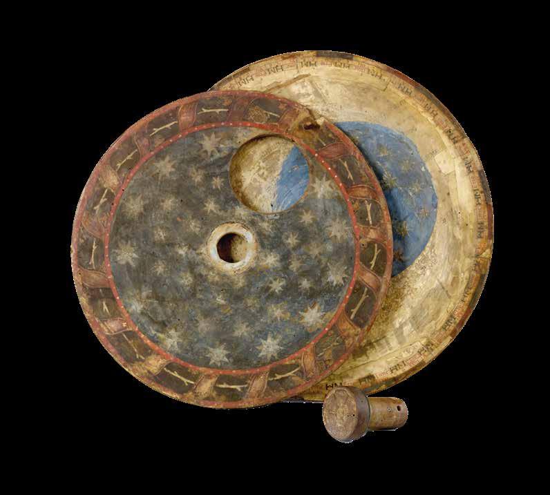
14. Depictions of the signs of the zodiac, with two labels stuck on each (some now missing), one inscribed with the name of the sign (Aquarius, Pisces, Aries, etc.), the other with the word “Bonum”, “Indifferens” or “Malum”, indicating whether it is a good, indifferent, or bad time for blood-letting.
15–16.Of the next two concentric circles, the inner one contains column headings “Lune”, “H”[orae, i.e. hours], “M”[inuta, i.e. minutes], and “Etas” (i.e. age), and the other one contains the numbers 1–30 under the alternate Lune and Etas headings, and with hours and minutes columns with numbers rising from 0:0 to 12:0 and then decreasing back to 0:0, in increments of eight: 0:0, 0:8, 1:6, 2:4 … 12:0, 11:12, 11:4 … 1:6, 0:8, 0:0. By turning a pointer attached to the innermost disc so that it points to the age of the moon, a hole in this disc reveals a depiction of the phase of moon, from new to full and back again, with intermediate crescents showing its waxing and waning.
Artist
The artist of the miniatures has not been identified. The art historian Caterina Gemma Brenzoni of Verona University studied the calendar a few years ago in relation to the restoration of the apse of San Zeno, which contains a remarkable fresco 24-hour clock-face on a wall to the left of the altar, numbered in both roman and arabic numerals, that presumably once had a mechanism to drive an hour-hand:
Copies of her unpublished work (Ricerche inedite d’archivio e lettura storico artistica della decorazione dell’abside della basilica di San Zeno, Verona 2008-2009) are deposited with the Banco Popolare Archive, Verona, and in the Biblioteca Civica di Verona. She kindly informs us that the closest stylistic paralells that she found were Lombard painters working in the middle of fifteenth century, such as the Maestro Paroto’s Madonna and Child with Saints and Crucifixion poliptych in the Bagatti Valsecchi Museum, Milan; the famous sets of ‘Tarocchi’ (Tarot cards) by the workshop of Bonifacio Bembo (Pinacoteca Brera, Milan) and works by the Zavattari brothers, such as the frescoes in the chapel of Queen Theodolinda, Monza Cathedral, executed by Ambrogio and Gregorio Zavattari in 1444.
There is ample liturgical evidence that the calendar was made for the use of the Benedictine abbey of San Zeno, Verona.
44 DANIEL CROUCH RARE BOOKS SIC ITUR AD ASTRA

The highest grade (“Duplex maius”) feasts include:
21 March: Benedict, founder of the Benedictine Order
12 April: The Deposition of Zeno, bishop of Verona
21 May: The Translation of Zeno
8 December: The Ordination of Zeno
10 December: The Dedication of the Basilica of San Zeno
The next highest (“Duplex minus”) feasts include:
28 March: The Octave of Benedict
5 September: Crescentianus, bishop of Verona
The next highest feasts (with 12 readings) include:
23 March: Proculus, bishop of Verona
29 April: Peter Martyr, who was born in Verona
22 May [added:] Lupicinus, bishop of Verona
13 July: Anthony Abbot, “the father of all monks” and probably (but the grading is damaged)
31 October: Lucillus, bishop of Verona
The calendar is recorded attached to a wall in the cloister of San Zeno in the mid-eighteenth century: Giambatista Biancolini, Dei Vescovi e Governatori di Verona [Bishops and Governors of Verona] (Verona, 1757), p.22, in a section discussing the former bishop of Verona St Lupicino, has the following passage:
“Curioso Calendario si sta annicchiato nella parete della Loggia che dal Dormitorio del Monistero Zenoniano conduce al Coro e alla Sagristia di quella Chiesa. Codesto Calendario è molto bello, ampio ed esatto, scritto sopra carta su di una tavola sferica che si può girare attorno per comodo de’ leggittori, e vi su posto del 1455. per uso degl’ istessi Monaci di San Zenone. Nel medesimo de’ nostri santi Vescovi si leggono S. Procolo, S. Lucillo, S. Zenone e S. Cerbonio solamente. Ma non fi sa il perchè vi manchi S. Lupicino, il cui sacro Corpo insieme con quelli di S. Lucillo e del Martire S. Crescenziano (il qual S. Martire nel detto Calendario si sta eziandio registrato) per tempo immemorabile nella suddetta Chiesa si riposa, mercecchè in un Catalogo de’ nostri Santi Vescovi in un Codice Miscellaneo della Librerìa Zenoniana, più antico del suddetto, standosi registrato il nome del suddetto Santo, vi su al nome medesimo da mano più recente aggiunto: cujus Corpus in Ecclesia S. Zenonis.”
This may be loosely translated as:
“A curious calendar is tucked into the wall of the loggia which leads from the dormitory of San Zeno monastery to the choir and the sacristy of the church [i.e. the East side of the Cloister]. This calendar is very beautiful, large, and accurate, written on paper [sic] on a circular panel that it is possible to rotate for the convenience of readers, placed there
46 DANIEL CROUCH RARE BOOKS SIC ITUR AD ASTRA
about 1455 for use of the monks of San Zeno. In it one can only read the names our sainted bishops San Proculo, San Lucillio, San Zeno and San Cerbonio. But it is unknown why it lacks San Lupicino whose sacred body, together with those of San Lucillo and the martyr San Crescenziano (who is recorded in the said calendar) rests in the said church since time immemorial, since in a list register of our sainted bishops in a miscellaneous codex in the library of San Zeno, the oldest of the latter, is recorded the name of the said saint, by whose name is added in a more recent hand: ‘whose body is in the church of San Zeno’”.
If Biancolini is correct about the date of the placement of the calendar in 1455 (he must have had information no longer available, perhaps an inscription painted on the wall of the cloister, or perhaps a document in the abbey archives, now lost) then it was doubtless commissioned by Gregorio Correr (1409–64), who was Abbot of San Zeno from 1448. A somewhat earlier date than 1455 is perhaps suggested by the absence of the feast-day (20 May) of St Bernardino of Siena, however: he died in 1444, was canonized in 1450, and the feast was quickly adopted by liturgical calendars throughout Italy.
San Zeno was plundered by Napoleonic troops in 1797, one result of which is that the three predella panels of Mantegna’s San Zeno Altarpiece, commissioned by Abbot Correr and painted c.1457–60, are today at Paris in the Louvre and at Tours in the Musée des Beaux-Arts.
By the early twentieth century the calendar was the property of the Conte Antonio Maria Cartolari of Verona (born 1843 - see Vittore Spreti, Enciclopedia storico-nobiliare italiana: famiglie nobile e titolate viventi riconosciute …, II (1929), pp.344-5.), and it may have entered the noble family’s collection during the Napoleonic upheavals through one of their ancestors: they are recorded as owning a portrait of an ancestor called Bartolomeo who was a monk of San Zeno (Inscribed “Bartholomaeus de Fanzago Cartulariis, S. Zenonis Majoris Ver. Cenobii Monachus filius Io[hannes] Baptistae e consilio Nobilium gubernatoris S. Montis Pietatis”; see Avena and Callegari, p.29). It is not known exactly when the Calendar left the Cartolari family collection (Conte Antonio Maria was born in 1843, married in 1869, and was apparently still alive in 1929 - when the Enciclopedia cited above was published - but was dead by 1943 unless he lived for more than 100 years.), but a portrait of a Woman with Green Vest, White Blouse and Red Choker by Pietro Antonio Rotari was sold by the descendants of the Conte Antonio Maria Cartolari in the 1970s, and is now in the Norton Simon Museum, California.
Provenance:
1. Benedictine monastery of San Zeno in Verona;
2. which was plundered by Napoleonic troops in 1797; by descent through thenoble Cartolari family; to the Conte Antonio Maria Cartolari of Verona (born 1843 - after 1929).
48 DANIEL CROUCH RARE BOOKS SIC ITUR AD ASTRA

VOOGHT, Claes Jansz. [after] Jan Jansz STAMPIOEN
Onderwysing van’t Gebruyk des Hemels Pleyn Waar op de starren des hemels na ’t oogh in ’t plat gestelt zyn[.] Tot nut en vermaak van alle liefhebbers der wiskonsten.
Publication Amsterdam, Johannis van Keulen, [c16801696].
Description
Large engraved celestial chart with a rotating printed paper ring (volvelle or rete) on an off-centre axis to indicate the part of the sky visible at any date and time and to make a variety of celestial calculations, all for the Netherlands’ latitude of 52 degrees. A string with two beads serves as a pointer for aligning the scales in the stationary and rotating parts. With engraved instructions also by Vooght. Coloured by a contemporary hand and mounted on contemporary boards covered with marbled paper, apparently by the publisher, so that it can be folded in half for carrying. The string may be a modern replacement.
Dimensions 560 by 660mm. (22 by 26 inches).
References
Bierens de Haan 5117?; Bom, Bijdragen ... Van Keulen, appendix B, p. 21?; Cat. NHSM, p. 640; E.O. van Keulen et al., “In de Gekroonde Lootsman,” item 4 & illustration between pp. 64 & 65 (NHSM copy); Koeman IV, Keu 28, map 6, p. 5 & p. 370, item 272 (without volvelle); Tiele, Land- en Volkenkunde 593 note; De Vries, et al., Van Keulen Cartography, p. 207, item 240; Warner, Sky Explored, p. 260, items 1 & 1a; Adler Planetarium on-line database A-286; cf. V.d. Krogt, Advertenties 130 (1696 ed., pub. by Loots); not in BMC Printed Maps; Cat. Nat. Mar. Mus.; Nordenskiöld; Zinner, Astron. Instrumente; NCC/Picarta; OCLC WorldCat.
$30,000.00
Vooght’s rare star chart and astronomical calculator, here separately issued in portfolio form and in its first state.
The chart shows the stars visible from 52 degrees latitude in a polar equidistant projection, with a rotating volvelle or rete to indicate the part of the sky visible at a particular moment. The circular border around the sky image and the outer part of the volvelle include scales with several kinds of data so that the chart can be used for various purposes. One can use the string to align the time in the volvelle with the date in the border of the chart, so that the part of the sky visible at that moment appears inside the volvelle. The chart with its volvelle, scales and string can also be used to calculate times for the rising and setting of constellations at various dates (or to calculate the present time based on the position of the stars). Fifty-three constellations are numbered quarter by quarter (15, 9, 14, 15), with a Dutch key identifying them in each corner and a French and an English translation in strips of panels at the head and foot. The instructional text, describing six “proposals” (the first explaining the different scales, etc., and the others giving examples of the use of the chart), stands to the right of the chart itself, and with the text were printed together from a single plate. If the ring is turned with 12 midnight to the right, the boards can be folded to each other like a portfolio, protecting the chart and making it easier to carry. It appears to have been published in this form, for the copy at the Dutch Maritime Museum in Amsterdam is similarly coloured and mounted to make a similar marbled portfolio. The only other complete copies we have located, at the Boerhaave Museum in Leiden and the Adler Planetarium in Chicago, are also in portfolio form. Though designed for use at a latitude of 52 degrees, the text suggests it remains accurate from 49 to 55 degrees, which would allow its use through much of northern Europe.
Although astrolabes had long used a rotating off-centre ring to denote the part of the sky visible at a given time, such a ring combined with a planispherical star chart (like the cardboard or plastic star finders still popular today) often is supposed to be a nineteenth-century invention.
Jan Jansz. Stampioen’s 1664 chart seems to be the earliest well-documented chart of this kind, though some suppose his father’s ‘Coelestum Planum’, mentioned in a 1619 patent and documented in 1621, was such an instrument, and Kepler’s son-in-law, Jakob Bartsch, is also said to have made something similar. Vooght clearly based his chart on Stampioen’s 1664 edition, published by Hendrik Doncker with text by Dirk Rembrandtsz. Van Nierop. Neither it nor the 1684 version (also apparently published by Doncker) is known to survive (unless the latter was the chart alone, without volvelle or instructive text), so that Vooght’s version in its present first state is the earliest known example. Comparison with a c. 1722 edition printed from Doncker’s original plate suggests that Vooght followed Stampioen closely, with the same 53 constellations (the latest introduced
50 DANIEL CROUCH
BOOKS SIC ITUR AD ASTRA
RARE
8
Vooght’s rare star chart and astronomical calculator

by Mercator and Plancius in the sixteenth and early seventeenth centuries) and the text in the corners describing them copied word for word and line for line.
In 1678/79 Van Keulen (1653/54-1715) set up at the address in the present chart (at the sign of the Crowned Pilot, opposite the new Bridge) and in 1680 he and Vooght (c. 1637?-1696) began to publish their charts with the privilege granted then, and re-granted to cover the years 1695 to 1710. The chart in its present first state must date between 1680 (since it notes the fifteen-year privilege) and 28 August 1696 (four months after Vooght’s death), when Johannes Loots described Vooght’s chart as new in an advertisement for his edition, also separately issued, his instructional text (by Simon van de Moolen, not mentioned in the advertisement) appears on a separate slip pasted over the engraved text, so his edition must be later than Van Keulen’s. The present chart, moreover, makes no reference to Vooght’s 1696 death. The chart is also mentioned in a list of Van Keulen publications in the ‘Zee-Fakkel’ (Bom, not specifying the edition), though supposedly including Spanish text, presumably for the constellations (Bierens de Haan probably based his description on the same advertisement). The instructional text notes that the stars are depicted in accordance with the year 1700 (“na haar waare stand en rangh afgebeeld, zijnde geschikt na ‘t Jaar 1700”), but such charts were often calculated for a round-numbered year a few years in advance. The chart later appeared in some copies of Van Keulen’s atlases, though without volvelle in the only example we have located: his 1708/09 ‘Zee-Atlas’ (part I) at the Dutch Maritime Museum in Amsterdam (Koeman IV, keu 28, map 6: De Vries appears to err in citing a copy in Koeman IV, keu 110B, the 1709 ‘Zee-Fakkel’ at the Amsterdam university Library; and the Cat. nhSM , p. 50, errs in citing a copy in a 1684 edition of the ‘Zee-Atlas’). Thiele reports a copy in a 1681/1686 atlas, not now located. In numerous Van Keulen atlases from 1682 to 1695, Koeman reports two versions of a different celestial chart, but not this one.
52 DANIEL CROUCH RARE BOOKS SIC ITUR AD ASTRA

STAMPIOEN, Jan Jansz the Younger, [and] Marten CALMAM
Onderwys in ‘t Regte Gebruyk van het Hemels-Plyn strekkende tot nut en vermaak der liefhebbers.
Publication Amsterdam, Jochem Hasebroek, [c1722].
Description
Large engraved celestial chart by Stampioen with a rotating printed paper ring (volvelle or rete) on an off-centre axis to indicate the part of the sky visible at any date and time and to make a variety of celestial calculations, all for the Netherlands’ latitude of 52 degrees. With letterpress instructions by Calman on a separate slip at the right. The sky image 33 cm in diameter; the whole chart with the letterpress slip as mounted 49 x 61.5 cm. A string with a bead serves as a pointer for aligning the scales in the stationary and rotating parts. Coloured by a contemporary hand and mounted on contemporary boards covered with marbled paper, apparently by the publisher, so that it can be folded in half for carrying.
Dimensions
500 by 630mm. (19.75 by 24.75 inches).
References Koeman IV, p. 5 (no location noted; cf. p. 153); Warner, Sky Explored, p. 260, no. 1c (no location noted; cf. p. 247); Alder Planetarium on-line database A-259; cf. Bierens de Haan 4516 (1684 ed., not seen: see his Bouwstoffen II, pp. 386 & 429 note 5); E.O. van Keulen et al., “In de Gekroonde Lootsman,” item 4 & illustration between pp. 64 & 65 (1680/1696 Vooght/ Van Keulen ed.); not in BMC Printed Maps; Zinner, Astron. Instrumente; NCC/Picarta; OCLC WorldCat.
$30,000.00
Telling the time with stars
The chart is here in its third state, but we have located no complete example of any earlier version. The Boerhaave Museum in Leiden has the chart without volvelle or instructional text, published by Doncker, but the 1664 edition described in Doncker’s advertisement clearly included the volvelle and instructional text. Perhaps the surviving chart is the 1684 version mentioned but not seen by Bierens de Haan, who provides neither a detailed description nor a source for his information. They and the present version (printed from Doncker’s plate c1722) seem to have appeared only as separate publications, hence their great rarity. The circular border around the sky image and the outer part of the volvelle include scales with several kinds of data so that the chart can be used for various purposes. One can use the string to align the time in the volvelle with the date in the border of the chart, so that the part of the sky visible at that moment appears inside the volvelle. The chart with its volvelle, scales and string can also be used to calculate times for the rising and setting of constellations at various dates (or to calculate the present time based on the position of the stars). Fifty-three constellations are numbered quarter by quarter (15, 9, 14 and 15), with a Dutch key identifying them in each corner. Calman’s instructional text, printed letterpress on a separate slip (495 by 185 cm) and mounted to the right of the chart itself, describes the different scales, etc., then presents nine “proposals” (giving examples of the use of the chart). If the volvelle is turned with 12 midnight to the right, the boards can be folded to each other like a portfolio, protecting the chart and making it easier to carry. It may have been published in this form, for the only other copy located, at the Adler Planetarium in Chicago, is similarly mounted. The marbled paper covering the portfolio, similar to Wolfe 33-35, was common in the Netherlands in the late seventeenth and early eighteenth centuries. In the plate of the star chart itself is engraved, “Auct. J. Stampioen. ‘t Amsterdam by Iochem Hasebroek” but Hasebroek’s name is larger and in a different style than the rest of the lettering, and one can see traces of an earlier name under it. Although the older name cannot be deciphered, one can see that “Hendrick Doncker” would fit (with traces of the h and Do, and marks where the ascenders to the d, k and k would have been), making it clear that the present chart is printed from Doncker’s original plate. Calman advertised his Amsterdam boarding school for calligraphy, mathematics, etc. in 1722, and Hasebroek (1682- 1756) is recorded as a sea chart publisher and instrument maker from 1714 to 1743.
54 DANIEL CROUCH RARE BOOKS SIC ITUR AD ASTRA
9


Planispherum Lunare cujus ope Locus medius Solis Lunae, ejusdemque Nodorum, Solis Declinatio, Lunaeque Latitudo Simplex, atque ejus Argumentum, necnon Novitunia et Plenitania Ecliptica simul inveniuntun.
Publication [c1800].
Description
Ink and polychromy on paper over pine. The instrument comprises a circular base plate, and three rotatable cardboard volvelles, and a brass radius pointer, attached to each other in the centre. A brass ring is attached to the base plate for suspending. All four paper covered discs are finely inscribed in manuscript with various scales and symbols.
Dimensions
470mm in diameter.
References
Oxford Dictionary of National Biography; Webster, Roderick and Marjorie, ‘Western Astrolabes’, Adler Planetarium & Astronomy Museum, 1998; Museo di Storia della Scienza, Florence, Italy
$25,000.00
A unique manuscript lunar astrolabe
Content
1. The smallest volvelle bears a scale covering 12 hours on its outer ring. It also shows the ecliptical motion of the Sun, the Moon’s orbit, the line of nodes, and the arguments of latitude (in other words, the distances from the nodes).
2. On the second volvelle, a scale covers the years from 1801 to 1825. Each year is subdivided in twelve months, with the abbreviated name written for each month.
3. The following volvelle carries a series of scales showing a monthly calendar, a zodiac calendar with skilfully drawn pictures and the symbols of the signs. Below the zodiac is a scale for the declination of the sun throughout the year, set in four sequences of three.
4. On the outside rim of the volvelle is another calendar scale in which the months are unevenly distributed. This scale presumably was to be used in conjunction with the outer scale on the circular base plate. In addition, the volvelle holds two brass studs that most probably helped the user turn the disc to the desired position. This latter scale gives the days, subdivided in hours. The days are numbered I to XXXI, with the number I coinciding with XXVII and 8 hours (the sidereal period of the Moon), which results in a double numbering from XXVIII to XXXI. Below this scale for days, there is a series of dates, all confined to the period 1801 to 1825, presumably for solar eclipses. The brass rule or pointer holds a horizontal scale from 5 to 0 (LA-southern declination) and from 0 to 5 (LB-northern declination), indicating the latitude of the moon with respect to the ecliptic. The closer to 0 at new moon or full moon, the likelier an eclipse is to occur. The rule is engraved with “Locus Lunae”. The circular scales serve to set the moon’s position and node relative to the sun, from which the user can then infer the lunar phase and whether an eclipse will occur at new moon or full moon.
58 DANIEL CROUCH RARE BOOKS SIC ITUR AD ASTRA
[Anonymous]
Manuscript instruments of this type are rare, especially in such good condition, as no other exact copy is recorded to date. Similar instruments were produced at the end of the sixteenth century, mostly in brass. Sir Robert Dudley (1573-1649) had a lunar calculator made by Charles Whitwell (c1568-1611) a brass disc of 72 cm diameter overall, which was the most complex instrument made during the sixteenth century. Inscribed ‘Sir Robert Dudley was the inventor of this instrument’, its purpose was to calculate the place of the moon over a period of thirty years. It is now in the Museo di Storia della Scienza in Florence, Italy. Another similar paper device was printed, with detailed instructions, in 1786 in Vlissingen (Flushing) in the Netherlands, advertised as a “Starkundige Maan-Wyzer en Almanach” (Astronomical Moon Pointer and Almanac) by Henricus Schortinghuis. 10
 BLAEU, Willem Janszoon
[Pair of nine-inch table globes].
Publication
Amsterdam, 1602 [but c1621].
Description
Terrestrial and celestial globes, each with 12 hand-coloured engraved gores heightened in gold, with two polar calottes, over a papier mâché and plaster sphere, rotating on brass pinions within a brass meridian ring with graduated scale, and a graduated brass altitude quadrant, set into a seventeenth century Dutch wooden base with an engraved horizon ring, adumbrating scales, calendar, almanacs etc. With usual defects: paper equinoctial tables present gaps that are filled and restored, small splits along the gores, several partially deleted entries, small scattered spots but in general in good condition for such an early globe pair, modern hour circles and pointers.
Dimensions
Diameter: 230mm (9 inches).
References
Dekker GLB0152, van der Krogt, Globi Neerlandici BLA III; GLB0083 (terrestrial) and GLB0151 (celestial).
$380,000.00
Biography
Willem Janszoon Blaeu (1578-1638) started “one of the most successful publishing houses of the seventeenth century” (Dekker). Originally trained in astronomy, he quickly became a leading maker of maps, atlases and instruments. At the time the Low Countries hosted the best cartographers in Europe, and Blaeu produced ever more accurate and more beautiful globes, spurred by his rivalry with fellow Dutch cartographer and publisher Jodocus Hondius.
Blaeu’s globes were luxury items for wealthy and intellectual merchants and nobility who benefited from Blaeu’s access through the Dutch East India Company to the latest navigational discoveries and geographical information. As van der Krogt observes, “During the preceding century, more than half of the known world, including the entire western hemisphere, had been charted and, more recently, during Blaeu’s own time, large portions of the Pacific were being explored”. Dutch explorers had played a key role in the expanding European worldview: from Olivier van der Noort’s circumnavigation of the earth, to Willem Barentsz’s attempts to find the Northeast Passage. Blaeu also had the advantage of considerable personal technical skill: he studied under the astronomer Tycho Brahe to create a star catalogue for his first celestial globe.
Blaeu’s pair of 230mm (9 inch) table globes are amongst the rarest to survive in comparison with the smaller or larger globes by Blaeu (100, 150, 340 and 680mm; 4, 6 13.5, and 26 inches).
Geography
Willem Jansz Blaeu (1571-1638) collected information that Dutch mariners gathered from around world and brought back to Amsterdam. Crews were instructed to record information about the lands they visited and the skies they saw. Blaeu incorporated these observations in maps and globes. Through his web of contacts and thanks to assiduous research, he was also able to obtain the most recent information about the latest discoveries in the western hemisphere and the South Pacific, where Dutch explorers were particularly active at the time.
Since the globe was published after 1618, Blaeu was able to include the discoveries made by Henry Hudson in his attempt to find a passage to the East Indies. He also included recent Pacific discoveries of the celebrated voyages of Willem Cornelis Schouten and Jacob Le Maire, who both traversed the South Pacific and the Atlantic in 1616. The findings of Schouten and Le Maire in the Tierra del Fuego region are also incorporated.
60 DANIEL CROUCH RARE BOOKS SIC ITUR AD ASTRA
11
“Amongst the rarest to survive”

The Strait of Le Maire is drawn and the hypothetical southern continent is labelled “Terra Australis Incognita Magalanica”. Olivier van Noort’s track is drawn and labelled. His route is indicated with a broken line and the words: “Navigationis Olivierij ductus” (several times). There are various decorative features, such as animals on the different continents, many ships on the high seas and allegorical and mythical figures around the cartouches.
The nine-inch globe is not just a smaller version of the one published in 1599. Drawings of animals and people do often correspond to those on the earlier globe, but Blaeu made several significant changes.
- The west coast of North America is drawn differently and the river system of Brazil is altered.
- The hypothetical southern continent is labelled: Terra Australis Incognita Magalanica.
- There are nine ocean names in handsome curling letters: Mare Congelatum, Mare Atlanticum, Oceanus Aethiopicus, Mare Arabicum et Indicum, Mare di India, Oceanus Chinensis, Mar del Zur, Mare Pacificum, Mar del Nort.
- Willem Blaeu, always eager to display the latest discoveries, traced the route of Van Noort’s route with a broken line. The findings of the voyage of Schouten and Le Maire in the Tierro del Fuego region are included, despite the 1602 date (names: Fr. Le Maire, Mauritius, Staten Landt, C.Hoorn, I.Barneveltij).
Astronomy
The first maker of globes from the northern Netherlands was the cartographer Jacob Floris van Langren (before 1525-1610). He published his first terrestrial and celestial globes in 1586 with a diameter of 325mm (12.75 inches) the terrestrial globes being based on the work of Mercator. The second edition of the celestial globe was improved after the observations of the southern hemisphere by Pieter Dirkz Keyser and Frederik de Houtman were incorporated by the geographer Petrus Plancius (1552- 1622), who was also influential as a globe maker.
Two other famous Dutch mapmakers produced celestial globes: Jodocus Hondius the Elder (1563-1612), one of the most notable engravers of his day, and Willem Jansz Blaeu (1571-1638).
62 DANIEL CROUCH RARE BOOKS SIC ITUR AD ASTRA


Publication history
According to Peter van der Krogt, the following states are known:
Terrestrial
First state: 1602 (no known examples).
Second state, c1618-1621 (no known examples).
Third state: 1602, but c1621 (the present example).
All the states are dated 1602 but the second state must have been published after 1618, since it includes the discoveries of Schouten and Le Maire (1615-1617), but not the name “Blaeu”. Dekker makes no distinction between the different states. The third state can be divided into states 3a and 3b. All globes have a different production number, some of which are illegible today. This terrestrial nine-inch globe is marked with “fabr. nr. 4”.
Celestial
First state: 1602 (known in a catalogue record but no known example surviving).
Second state: presumably published after 1621.
All 30 known celestial globes are in the second state, as this one, which is marked with “fabr. no. 12”. Rare: there are 19 recorded pairs, of which 14 are in institutions.
66 DANIEL CROUCH RARE BOOKS SIC ITUR AD ASTRA

PLANCIUS, Petrus
In hac coelestis Sphaera stelle Affixae majore. De integro addidi: quae omnia secundum
Astronomorum Principis Thyconis
Brahe... observationem verae suae Longitudini, ac Latitudin.
Publication
Petrus Plancius, 1625.
Description
Globe, 12 hand-coloured engraved gores, over a papier ma âche é and plaster sphere, with metal pins, supported by a wooden structure of four arms with a circular band with partially applied graduated paper, set into a modern wooden base.
Dimensions
Diameter: 245mm (9.75 inches).
References
van der Krogt KEE I; Science Museum Group 1986-427; for reference see Stevenson vol. II, pp.46-50.
$85,000.00
Biography
Petrus Plancius (1552-1662), a theologian and geographer, was one of the most influential cartographers of his day. He was forced to flee to Amsterdam in 1585, for fear of persecution as a Protestant minister. There he began his cartographical career, studying Portuguese charts and becoming friends with the explorer Henry Hudson. He issued his impressive world map in two hemispheres entitled ‘Nova et exacta terrarum orbis tabula geographica ac hydrographica’ in 1592, which likely influenced both Blaeu and Hondius in the preparation of their masterpieces published in 1605 and 1611, respectively.
In addition to his world map, Plancius turned his eyes to the skies. In 1589, he collaborated with the Amsterdam cartographer Jacob Floris van Langren on a 325mm (12.75 inches) celestial globe incorporating the limited information available about southern celestial features, which included Crux (the southern cross), Triangulum Australe (the southern triangle) and the Magellanic Clouds (Nubecula Major and Minor).
On a quest to expand knowledge of the southern hemisphere, Plancius commissioned Pieter Keyser, to record as many southern stars as possible on his voyage of the Indies in 1595. Although Keyser died at sea in 1596 before his return, he was able to record about 130 stars alongside his colleague Frederick de Houtman, and the records reached Plancius when the surviving voyagers returned. Plancius took these new discoveries and divided the stars into 12 new southern constellations, which mostly referred to animals and subjects described in natural history books and travellers’ journals of his day. The constellations are: Apis the Bee (later changed to Musca by Lacaille), Apus the Bird of Paradise, Chamaeleon, Dorado the Goldfish (or Swordfish), Grus the Crane, Hydrus the Small Water Snake, Indus the Indian, Pavo the Peacock, Phoenix, Triangulum Australe the Southern Triangle, Tucana the Toucan and Volans the Flying Fish.
Plancius plotted these southern constellations on a 350mm celestial globe in late 1597 (or early 1598) in collaboration with the Amsterdam cartographer Jodocus Hondius the Elder. No copies of this globe survive, but in 1602 Blaeu produced a copy of the globe, now in the Maritime Museum.
These constellations, together with the constellation Columba that Plancius included on his 1592 map of the world, were then incorporated by Johann Bayer in his sky atlas of 1603, the ‘Uranometria’.
Plancius created another globe in 1612-1614, published in co-operation of Pieter van den Keere with updated celestial cartography. The celestial globe is inscribed with the following: “In hac coelesti sphaera stellae affixae majore quam hactenus numero ac accuratiore industria delineantur. Novos Asterismos in philomatheom gratiam de integro addidi: quae omnia secundum Astronomorum Principis Tychonis Brahe, ac meam
68 DANIEL CROUCH RARE BOOKS SIC ITUR AD ASTRA
12
The
sky according to Plancius

observationem verae suae Longitudinis ac Latitudinis ad annum Christi 1615 restitui. Petrus Plancius” (translation: “In this celestial sphere the fixed stars to a greater number than previously and with more exactness are depicted. I have added for the use of the student some entirely new star readings according to the prince of astronomers Tycho Brahe, and also my own observations of their true latitude and longitude adapting these to the year of Christ 1615. Peter Plancius”). Plancius includes a portrait of Tycho Brahe in the southern hemisphere. On this updated globe, Plancius introduced the following eight constellations: Apis the Bee, Camelopardalis the Giraffe (often interpreted as a Camel), Cancer Minor the Small Crab, Euphrates Fluvius et Tigris Fluvius the Rivers Euphrates and Tigris, Gallus the Cock, Jordanis Fluvius the River Jordan, Monoceros the Unicorn and Sagitta Australis the Southern Arrow. Of the latter constellations, only Camelopardalis and Monoceros are still found on modern star charts, and recognized by the International Astroninomial Union (IAU).
Astronomy
The names of the constellations are given in Latin along with alternative names, some in Greek. The 48 Ptolemaic constellations appear along with Antonious, Coma Berenices, Cruz (“Cruzero Hispanis, at Ptolomeo Pedes Centauri”), and Columba (“Hemame. Columba Noachi”). The 12 constellations of Plancius appear as well as a number of contellations that appear on the globe for the first time: “Apes”, “Gyraffa Ca-melopardalis”, “Monoceros, Callus”, “Cancer minor”, “Jordanis fluv:”, “Sagitta Aust:” and “Euphrates fluv en Tigris flu”. The magnitude chart is drawn and labelled “Magnitudo Stellarum”. One nova is shown and is labelled with the following notation: “Stella mirabilis quae insolito prae alijs fulgore a[nn]o 1571 per an[num] et tri-entem appa-ruit” (translation: The wondrous star, which shone with an uncommon shine compared to the others in the year 1571 for one and one-third years”.
A portrait of Tycho Brahe appears below the figure of Cetus.
70 DANIEL CROUCH RARE BOOKS SIC ITUR AD ASTRA

DELLA VOLPAIA, Girolamo [Armillary sphere].
Publication Florence, 1598.
Description
Gilt brass Ptolemaic armillary sphere, signed under the horizon ring, ‘Hieronymvs Vvlparia Floren(ti)nus Faciebat
A.D.M.D.LXXXXVIII’; brass, with wooden Earth sphere, set in a brass horizon ring on a turned wooden base, the horizon ring, divided to each degree in four quadrants of 90 degrees each, attached by two arcs attached to a tapering post which fits into the base, the top of which is prevented from splitting by a decorated brass ring; the horizon ring engraved in Latin with the names of the thirteen winds, the rotatable sphere supported within the horizon ring by a meridian ring, two great circles through the equinoxes and the solstices on the ecliptic circle,with the signs named, earthsphere axis with solar and lunar rings, turned fruitwood base.
Dimensions
200 by 120mm. (7.75 by 4.75 inches).
$60,000.00
A brass Ptolemaic armillary sphere
Girolamo della Volpaia (c1530-1614) was the last in a family of prominent Florentine instrument makers. His grandfather, Lorenzo di Volpaia, was active during the reign of Lorenzo the Magnificent, and built the famous planetary clock now held in the Palazzo Vecchio as a Medici commission. Lorenzo di Volpaia was a correspondent of Leonardo da Vinci, and was on the committee which decided the placement of Michelangelo’s David. His sons and grandson carried on the business. Girolamo made a name for himself in his own right after restoring the planetary clock his grandfather had made and carried out commissions in Venice and Siena. By the time Girolamo was active, the Medici were one of the great families of Europe. They had taken the title of Grand Dukes of Tuscany after Siena had been brought under Medici rule in 1560. Their growing wealth and power enabled a series of brilliant matches with royal houses from France to Lorraine. The family interest in science and the arts remained, and the Medici continued to buy instruments from the dell Volpaia workshop. This sphere would have been used to teach astronomical principles according to the theories of Aristotle and Ptolemy. It shows the earth at the centre of the universe; the heliocentric theories of the universe advocated by Copernicus and Galileo had not yet gained widespread acceptance, particularly in Italy.
Although there are a handful of extant instruments by Girolamo in existence, this sphere was unseen when it first came on the market and is not recorded in Maccagni.
72 DANIEL CROUCH RARE BOOKS SIC ITUR AD ASTRA
13

[A
Ptolemaic Armillary Sphere].
Publication
[Augsburg, late seventeenth century]. 1680.
Description
Brass, silver brass, steel.
Dimensions
570 by 420mm. (22.5 by 16.5 inches).
$150,000.00
A
This striking armillary sphere is built according to the Ptolemaic model; depicting the earth at the centre of the solar system. These models of the cosmos, either Ptolemaic (geocentric), or Copernican (heliocentric), were used as teaching aids for European nobility, and can often be seen in portraits of the time to denote the breadth of the sitters learning.
This particular example, somewhat unusually, rests on a compass with screw feet so that it can be leveled, and, although the work is neither signed or dated, the small volutes that connect the barrel to the compass as well as the engraving of the compass can be compared to table clocks and compasses from the Augsburg region; one of the major centres of scientific instrument production of the sixteenth and seventeenth century.
Construction
At the centre, the terrestrial globe is engraved with, the polar circles, the tropics, the equator, and the circle of the zodiac. The four continents are named: AMERICA, EUROPA, AFRICA, ASIA.
The globe is surrounded by five parallel rings: (from top to bottom) the Arctic Ring, Tropic of Cancer, The Equator, Tropic of Capricorn, the Antarctic Ring. The equatorial ring is slightly larger than the rest and bears a scale from 0° to 360° subdivided into units which mark every 5° and 10°.
A sixth ring or wide band, the Ecliptic, encompasses the Tropics of Cancer and Capricorn is graduated from 10° to 30°, and shows the signs of the zodiac.
The horizon ring also depicts the signs of the zodiac (the inner edge), with each divided into 30 degrees. Each sign is accompanied on the right by its Latin name: ARIES, TAURUS, GEMINI, CANCER, LEO, VIRGO, LIBRA, SCORPIUS, SAGITTARIUS, CAPRICORNUS, AQUARIUS, and PISCES. The centre is engraved with a calendar divided into days, with the names of the months in Latin: IANUARIUS, FEBRUARIUS, MARTIUS, APRILIS, MAJUS, IUNIUS, IULIUS, AUGUSTUS, SEPTEMBER, OCTOBER, NOVEMBER, DECEMBER as well as the inscription of the names of saints and religious holidays. The outer edge indicates the cardinal points accompanied by the fourteen winds also named in Latin (Vulturnus, Eurus, Aquilo, Zephyrus...).
The circle of the horizon is supported by four arms attached to the barrel resting on three volutes connected by screws to the silver brass compass with central decoration of a wind rose indicating sixteen directions. It is engraved on the rim with the cardinal points MERIDIES, ORIENS, OCCIDENS and SEPTENTRIO surrounded by a circular scale divided and numbered twice from 0 to 90 on either side of a fleur-de-lys.
74 DANIEL CROUCH RARE BOOKS SIC ITUR AD ASTRA
14
fine Ptolemaic armillary sphere

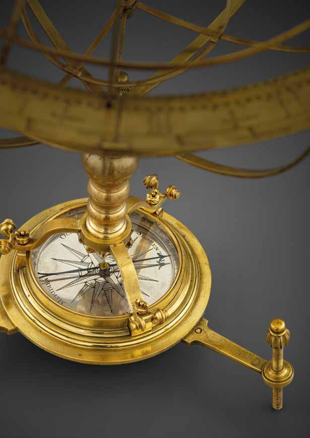
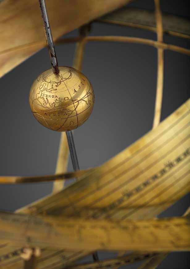
HOMANN, Joh[ann] Bap[tiste]
Globus Terrestris [and] Globus Coelestis.
Publication
Nuremberg, Opera loh. Bapt. Homanni Geographi, [c1702-1715].
Description
Globe, 12 hand-coloured engraved paper gores, over two wooden concave hemispheres, paste-board armillary sphere inside, housed within original black morocco over paste-board clamshell case, decorated with fine gilt daisy flower tools and fillets, with hook and eye, lined with two sets of 12 hand-coloured engraved celestial gores. Short split to globe in the northern hemisphere with early repair. In addition to the terrestrial and celestial globe, this pocket globe features a rare armillary sphere, which is revealed by opening the hollow wooden terrestrial globe.
Dimensions
Diameter: 64mm (2.5 inches).
References
Dekker and van der Krogt, pl.20; Sumira 22.
$135,000.00
Homann’s rare pocket armillary
The earliest state, previously unrecorded, of Homann’s only known pocket globe, here with rare ‘nesting’ armillary.
Biography
Johann Baptist Homann (1664-1724) was a German geographer and cartographer. He was educated as a Jesuit and destined for an ecclesiastical career, but converted to Protestantism and then worked as a notary in Nuremberg. He founded a publishing business there in 1702, and published his first atlas in 1707, becoming a member of the Academy of Sciences in Berlin in the same year. He collaborated with Johann Gabriel Doppelmayr on his book ‘Kosmotheoros’, which represented the solar system based on the Copernican system laid down by Christiaan Huygesn.
Homann was appointed Imperial Geographer to Charles VI in 1715, and produced his great work the following year, ‘Grosser Atlas uber die ganze Welt’. Homann was well placed to take advantage of the decline of Dutch supremacy in cartographic publishing, and he became the most important map and atlas producer in Germany. After his death, the company was continued by his son Johann Christoph. When Johann Christoph died in 1730, the company continued under the name of Homann Heirs until 1848.
Geography
Homann is only known to have produced one pocket globe. Although the present example reflects an earlier issue than previously identified, it does not include Homann’s title as Imperial Geographer, which he received in 1715. The globe features cartography plotted from recent observations of the Académie Royale des Sciences in Paris. In addition to his collaboration with Doppelmayr, Homman published the gores of George Christoph Eimmart’s globes in his atlases, which would have provided additional cartographic information. The equator is graduated and shows ecliptic and prime meridian. None of the Antarctic continent appears, nor is there a coast to northwestern Canada, or eastern Australia. “New Zeeland” and “Diemans Land” are shown only in part, and California is shown as an island.
78 DANIEL CROUCH RARE BOOKS SIC ITUR AD ASTRA
15


Astronomy
The celestial cartography appears on the inside of the clamshell case is graduated in degrees, the ecliptic is graduated in days of the houses of the Zodiac with sigils and the constellations are brightly coloured and depicted by mythical beasts and figures and some objects, with names in Latin. A cartouche gives the stars and nebulae to six orders of magnitude.
Armillary sphere
The miniature armillary sphere, with graduated meridian and three latitudinal bands, contains a miniature sun at its centre.
Rare. Only one institutional example is known: that in British Library, although the BL example exhibits different form of the armillary sphere.
80 DANIEL CROUCH RARE BOOKS SIC ITUR AD ASTRA

Showing the results of Bering’s expedition to the Kamchatka Peninsula
HILL, Nath[aniel]
A New Terrestrial Globe by Nath Hill 1754.
Publication [London], Nath Hill, 1754 [but c1755 or later].
Description
Globe, 12 hand-coloured engraved paper gores, clipped at 65 degrees latitude, with polar calottes, over a papier mâché and plaster sphere, varnished, housed within original shagreen over paste-board clamshell case, with hooks and eyes, lined with two sets of 12 hand-coloured engraved celestial gores, varnished. The terrestrial globe a bit toned.
Dimensions
Diameter: 70mm (2.75 inches).
References
For Hill’s 1754 pocket globe see Dahl and Gauvin, pp.93-95 (Stewart Museum 1979.28.2); for reference see Dekker, pp.355-357; van der Krogt, Hil 1 and Hil 4; Worms and Baynton-Williams, pp.318-319.
$20,000.00
Biography
Nathaniel Hill (fl1746-1768) was a surveyor, mathematician and instrument maker based in London. He started his career as an apprentice globemaker to Richard Cushee, and he later took on Cushee’s nephew, Leonard, as his apprentice. His shop was at the Globe and the Sun in Chancery Lane, and his trade card advertised “New and Correct Globes of 3, 9, 12 and 15 inches”. Hill’s most popular items were the three and nine-inch globes, which he published either as pocket globes, mounted on a stand or for orreries. After Hill’s death, his business was continued by Thomas Bateman, who took on John Newton and William Palmer as apprentices.
Geography
This pocket globe by Hill shows the rapid changes in European knowledge of the world. Although it bears the same date as another globe he published in 1754, it shows some significant revisions, the most obvious of which is the addition of trade winds. In Asia, the Caspian Sea has been reduced in width to reflect the findings of the Russian nautical surveyor, Feodor Soimonov, who thoroughly surveyed the sea for the first time between 1719 and 1727, and published his findings in 1731. The most significant development is the redrawing of eastern Russia, influenced by Vitus Bering’s second expedition to the Kamchatka Peninsula. Bering spent ten years (1733-1743) exploring along northern Russia, mapping the Arctic coast of Siberia, and reaching Alaska in North America. Bering died of scurvy during the voyage, and an island off the Kamchatka Peninsula was eventually named in his honour. Stephan Krasheninnikov published the first detailed description of the peninsula, ‘An Account of the Land of Kamchatka’ in 1755, which is possibly where Hill acquired the new information.
Astronomy
The celestial gores, lining the case, are geocentric in orientation and, in a departure from most previous pocket globes, are concave, thus depicting the constellations as seen from earth. Previous pocket globes, most notably John Senex’s pocket globe of 1730, simply used gores intended for celestial globes, thus rendering the night sky in reverse when pasted to the inside of the case. The difference is most noticeable in the orientation of Ursa Major, with the bear facing in the other direction.
82 DANIEL CROUCH RARE BOOKS SIC ITUR AD ASTRA
16


FERGUSON, James [and MARTIN, Benjamin]
A New Globe of the Earth by James Ferguson.
Publication [London], James Ferguson, J. Mynde Sc. [engraver], [c1775].
Description
Globe, 12 hand-coloured engraved paper gores, over papier mâché and plaster sphere, varnished, housed in original shagreen case with rims painted red and two original brass hooks and eyes.
Dimensions
Diameter: 75mm (3 inches).
References
Dekker GLB0057 (edition III- see p.132, table 9.1); see fig. 9.100; James Ferguson, Life of James Ferguson, F.R.S. (Cambridge: Cambridge University Press, 2010); John Millburn, Wheelwright of the Heavens. The Life and Work of James Ferguson (London, 1988).
$17,000.00
A fine pocket globe, showing the discoveries made by Captain Cook aboard the Endeavour.
Biography
For a biography of James Ferguson see item 16.
Geography
The globe features updated cartography from Ferguson’s c1756 globe (see item 16). Benjamin Martin acquired Ferguson’s plates in 1757 and produced an updated globe in c1775. In this new edition, the track of Captain Cook’s first voyage is marked as the “Endeavour tract”, and the coastlines of Australia and New Zealand have been updated with his discoveries.
Astronomy
The celestial cartography, lining the case, is the same as Ferguson’s 1756 globe (see item 16).


84 DANIEL CROUCH RARE BOOKS SIC ITUR AD ASTRA
The coast (of Australia) is clear
17

[ANONYMOUS, after MOLL, Herman]
A Correct Globe with the new Discoveries [and] A Correct Globe with ye new constelations of Dr. Halley &c.
Publication [London, c1775].
Description Globe, 12 hand-coloured engraved paper gores, clipped at 70 degrees latitude, with two polar calottes, over a papier mâché and plaster sphere, housed within original shagreen over paste-board clamshell case, rim painted red, with hook and eye, lined with two sets of 12 hand-coloured engraved celestial gores, clipped at 70 degrees declination, varnished. Globe with a crack extrending from the south pole in two directions to the southern tip of Africa and just south of New Zealand, other small areas of abrasion.
Dimensions
Diameter: 70mm (2.75 inches).
References
Dekker GLB0196; for Moll’s globe see Dekker GLB0197; Lamb, Collins and Schmidt 5.4; Sumira 21; for reference see Worms and Baynton-Williams, pp.456-458.
$11,000.00
Biography
A firm attribution for the maker of this globe has proven elusive. However, it is now recognised to have been at least designed after the work of the globemaker Herman Moll (for a biography of Moll see item 8).
This globe was formerly attributed to George Adams Snr. on the basis that it appeared in one of his instruments. However, it also appears in the instruments of several other publishers, which makes this unlikely.
Geography
The tracks of Dampier’s voyage have been partially erased and overlaid with the track of the first voyage of Captain James Cook (incorrectly dated “Cook’s Track 1760”), and the geography of Australasia adjusted accordingly, including the labelling of Cook Strait. It also adds the label “North.n Ocean” to the North Pole, although this is a preference of the cartographer rather than any new information, as the area was still largely unexplored.
Astronomy
The celestial cartography lines the inside of the case, and the ecliptic is graduated and provided with the signs of the zodiac. The polar circles and tropics are drawn but not named. A magnitude table (1-6) sits below Ursa Major. The 48 Ptolemaic constellations are marked along with four non-Ptolemaic constellations. Only five of the 12 southern Plancian constellations are named, and Scutum is not labelled among the Hevelian constellations.
86 DANIEL CROUCH RARE BOOKS SIC ITUR AD ASTRA
18
Showing the track of Cook’s ‘Endeavour’ voyage


MINSHULL, George after LANE, Nicholas
Minshull’s 1816.
Publication [London], 1816.
Description
Globe, 12 hand-coloured engraved paper gores, clipped at 70 degrees latitude, with two polar calottes, over a papier mâché and plaster sphere, paste-over imprint to cartouche, varnished, housed in original shagreen over paste-board clamshell case, with hooks and eyes, lined with two sets of 12 hand-coloured engraved celestial gores.
Dimensions
Diameter: 70mm (2.75 inches).
References
Dekker, pp.393-394; Sumira 35 and 45; Worms and Baynton-Williams, p.451.
$20,000.00
Biography
George Minshull (fl1800-1835) was a toymaker and carver. Although based in Birmingham, there was a “George Minshull & Son” registered in Hatton Garden in London in 1814, suggesting the globe was sold there. It was common for small cartographic items and scientific instruments to be sold alongside toys.
Geography
Minshull’s globe is an updated version of Thomas Lane’s issue of his father’s pocket globe. Minshull was one of several makers who reissued Lane family globes - his imprint has been pasted over the original. Nicholas Lane’s pocket globe, with completely new terrestrial plates, was first issued in 1779. His son, Thomas, updated the plates in 1807 and sold them wholesale. The present globe is based on Thomas’s updated plates.
“New South Wales, Botany Bay and Cape Byron are depicted in New Holland (Australia), and “Buenos Ayres” (Buenos Aires) appears in South America. Two years later there were more changes: Dimens Land (Tasmania) is separated from New Holland by the Bass Strait; Port Jackson (Sydney) is added to the eastern coast of the mainland; and Sharks’ Bay and ‘South C.’ are newly marked on the western side. The Antipodes of London are also shown. In northwest America, “New Albion” and the “Stony Mountains” (the Rockies) have been added. Curiously, the date of Captain Cook’s death, 14 February 1779, is another late addition squeezed in below the Sandwich Islands” (Sumira).
By 1816, the date of the globe shown here, the geography has been altered yet again: “At the southern tip of the Californian peninsula, “C. S. Lucas” (Cape San Lucas) is now shown... “Dampier’s Anchor”, where William Dampier first reached Australia, is marked off the north west coast of New Holland, and we see a mysterious “Labyrinth” [The Great Barrier Reef] off the north-east coast” (Sumira).
Astronomy
The celestial gores, which were acquired by Nicholas Lane from Richard Cushee sometime in the mid-eighteenth century, are geocentric in orientation. The difference is most noticeable in the orientation of Ursa Major, with the bear facing the other direction. The deep green colour is characteristic of Lane globes. Minshull has put his own stamp on the celestial gores by only colouring the constellations in green.
88 DANIEL CROUCH RARE BOOKS SIC ITUR AD ASTRA
19
A toymaker’s globe


BRUN, Emmy Ingeborg
Mars efter Lowell’s Glober 18941914.
Publication
Denmark, 1909.
Description
Globe, papier mâché with original ink and body hand-colouring, plaster coating, varnished, bronze stem and base.
Dimensions
Diameter: 210mm (8.25 inches). Overall height: 420mm (16.5 inches).
References
George Basalla, Civilized Life in the
Universe: Scientists on Intelligent Extraterrestrials (Oxford: Oxford University Press, 2006).
$75,000.00
Life on Mars
A rare and fascinating manuscript globe of Mars made during a period of renewed interest in the red planet and suggestive of the possibility of Martian civilisation.
Biography
Emmy Ingeborg Brun (1872-1929) was a Danish writer, socialist and astronomer. She had no formal training - her father did not allow her to go to university - and spent long periods of her life bedridden, but was fascinated by the theories of contemporary astronomers Percival Lowell and Giovanni Schiaparelli, and the political scientist Henry George.
Mars in the Twentieth Century
Improving contemporary scientific observation of Mars was accompanied by a corresponding interest in socio-political thought in the planet as a potential site for socialism or communism. This took the form of fiction, like Alexander Bogdanov’s 1908 novel “Red Star”, and was also addressed in scientific theories. In 1855 Schiaparelli observed a network of dark lines on the Martian surface. When he published his findings, along with the first detailed modern map of Mars, he named them “canali”, and suggested that they were built by a socialist regime, as a planet-wide system suggested a lack of national boundaries (Basalla).
Lowell popularised these theories by publishing three books on the subject, claiming these lines were indeed a canal network and raising the possibility of a Martian civilisation, although he opted for a “benevolent oligarchy” (Basalla). Brun was intrigued by these canals, which she saw as evidence of a different, more co-operative form of society. Mars was the potential site for a socialist utopia - and in particular, a potential field for an implementation of Henry George’s theories of a land-tax, as proposed in his 1879 work ‘Progress and Poverty’, in which he argued against a system of profit from renting land or property without contribution.
Brun adapted Lowell’s maps into manuscript globes, painting her interpretations on top of existing printed globes. After showing them to experts in the field, she donated them to various astronomical observatories and institutions. She sent one to Lowell himself in 1915, who replied warmly that it was “a capital piece of work”, although it was initially arraigned at customs because the officers thought it was a bomb.
90 DANIEL CROUCH RARE BOOKS SIC ITUR AD ASTRA
20
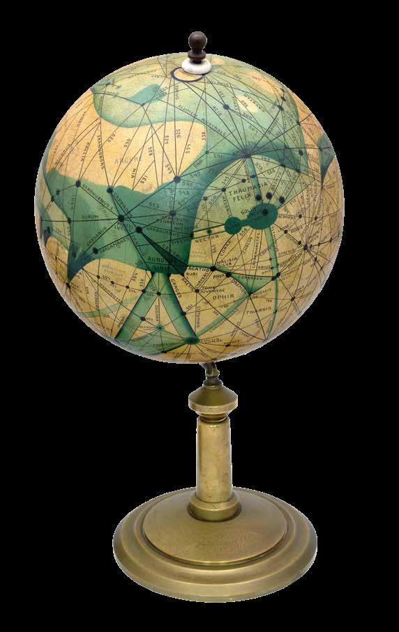
Geography
The globe uses Lowell’s territorial observations and Schiaperelli’s nomenclature for the features, most of which is no longer used. The North Pole is inscribed “Nix 1909”, and the bronze base carries the inscription “Free Land. Free Trade. Free Men”, a slogan inspired by the work of the political economist Henry George, and a line from the Lord’s Prayer: “Thy will be done on earth as it is in heaven”.
We have traced seven institutional examples: the National Maritime Museum, Greenwich; National Museum of Scotland, Edinburgh; Whipple Museum of the History of Science, Cambridge; Museo Specula Vaticana, the Vatican; Museum Observatoire Camille Flammarion, Juvisy-sur-Orge; Ole Rømer Museet, Taastrup; Randy and Yulia Liebermann Lunar and Planetary Exploration Collection. One example appeared at auction at Bonham’s New York on 5th December 2012, selling for $50,000 (Lot 129).
92 DANIEL CROUCH RARE BOOKS SIC ITUR AD ASTRA

[a, b] ANONYMOUS
[c] Li Shoupeng
[d, e,f] [Wang Zhiyuan after Huang Shang]
[a, b] Yu ji tu 禹跡圖(Map tracing the tracks of Yu the Great); Hua yi tu 華夷圖 (Map of the Chinese and non-Chinese).
[c] Pingjiang tu 平江圖 (Map of Suzhou city).
[d, e, f] Dili tu 墜理圖 (Geographic Map of China); Tianwen tu 天文 圖 (Map of the heavens); Diwang shaoyun tu 帝王紹運圖 (The chronological table of Emperors).
Publication
[a, b] Xi’an, c1900 [1136].
[c] Suzhou, [绍定二年, 1229].
[d, e, f] [Suzhou, 1247 but later].
Description
Ink rubbings from stone steles.
Dimensions
[a, b] 800 by 790mm (31.5 by 31 inches);
790 by 780mm (31 by 30.75 inches).
[c] 2680 by 1365mm (105.5 by 53.75 inches).
[d, e, f] 1790 by 960mm (70.5 by 37.75 inches); 1810 by 985mm (71.25 by 38.75 inches); 1830 by 965mm (72 by 38 inches).
$300,000.00
The Iconology of Empire
A collection of six stone stele rubbings comprising the earliest geographically accurate map of China, the first urban plan made within the realm, and the oldest stone-engraved celestial map of the Chinese heavens.
The original engravings were made between 1136 and 1247 during the Southern Song dynasty. Together they represent a comprehensive study of ancient Chinese cartographical rubbings.
Among the earliest techniques in the art of Chinese cartography is that of making rubbings from stone steles. Unlike copperplate or woodblock prints which show the reversed image of the carved surfaces, rubbing is akin to photography, drawing the image directly from the object. Ink is applied to paper laid over engraved stone or wood, thus registering the entire surface of the object; the engraved inscription or image appears white against a black background. The present rubbings were taken in the late nineteenth century; whilst the stone steles themselves remain intact, they are now significantly weathered, and it is no longer possible to take impressions. Thus, each rubbing is incredibly rare and to have a set of six is remarkable.
Some of the earliest Chinese imperial maps are stone rubbings. Empire maps were graphic representations of territories that symbolised imperial power and bore the transhistorical significance of the Chinese dynasties.
The present collection includes some of the earliest examples of such maps, including the twelfth century Yu ji tu 禹跡圖 (Item a) and Hua yi tu 華夷圖 (Item b). The present pair of Yu ji tu and Hua yi tu were engraved in the same year, AD 1136, on the two sides of the same stone tablet. The former is the earliest extant map of China intended to be geographically accurate, and the latter the earliest surviving map of China to relate the empire with foreign states.
Pingjiang tu 平江圖 (Item c) is the largest extant stone rubbing map, displaying the first ever city plan made in China, of Pingjiang, now Suzhou, in the Jiangsu Province. The map was originally engraved on a large stone stele in AD 1229 during the Southern Song Dynasty, and is one of the most complete and detailed Chinese urban plans. It depicts the city walls and gates, government and police buildings, water channels, streets, 359 bridges, 250 temples, public venues and residential blocks.
The original stele Pingjiang tu is held at the Confucian Temple in Suzhou, along with the other three stone steles engraved with Dili tu 墜 理圖 (Item d) – one of the earliest extant maps of the entire geography of China, Tianwen tu 天文圖 (Item e) – the earliest extant stoneengraved example of a celestial map, and Diwang shaoyun tu 帝王紹運 圖 (Item f) – the only extant chart depicting the lineage of the emperors throughout the imperial history of China.
These three maps were part of a set of eight paintings originally made and presented to the future Song Emperor Ningzong (r.1194-1224 AD)
94 DANIEL CROUCH RARE BOOKS SIC ITUR AD ASTRA
21

a
in c1190 by scholar official Huang Shang 黃裳, who was appointed Ningzong’s tutor. The set was intended as a warning of how much land had been lost to the northern barbarians, and as a reminder of the sovereign’s responsibility to reunite the empire. In the year of 1247, Wang Zhiyuan 王致遠, who was a scholar during Emperor Ningzong’s reign, obtained the set of eight paintings and engraved them onto stone steles. Common to all three maps is the text in the lower half which accounts for the image above.
The Chinese empire was thus preserved and promulgated by the engraving of such maps on the enduring medium of stone, serving as a concrete means of asserting authority and territorial claims.
96 DANIEL CROUCH RARE BOOKS SIC ITUR AD ASTRA

b

c

d

e

f
CELLARIUS, Andreas
Tychonis Brahe Calculus
Planetarum Cursus et Altitudines
Oboculos Ponens.
Publication
Amsterdam, 1661.
Description
Double-page engraved chart, with fine hand-colour in full.
Dimensions
510 by 525mm. (20 by 20.75 inches).
$3,200.00
An exquisite example of Cellarius map of Tycho Brahe’s model of the Universe with gold highlights.
Tycho Brahe was the last of the great “naked eye” astronomers. As a compromise between the models of Ptolemy and Copenicus, the Danish Astronomer Tycho Brahe proposed a model of the Universe which placed the earth at the center of the Universe and the Sun and Moon circling the Earth but the other planets revolving around the Sun. His system was intended to harmonize the mathematical observations of Copernicus with the ecclesiastical imperatives of the times, namely, preservation of Ptolemy’s geocentric model of the Universe.
This chart provides Tycho Brahe’s calculations of the courses and altitudes of the planets, in support of his helio-geocentric model. He believed that the Earth was too sluggish and heavy to be continuously in motion. According to the accepted Aristotelian physics of the time, the heavens (whose motions and cycles were continuous and unending) were made of “Aether” or “Quintessence.” This substance was light, strong, unchanging, and its natural state was circular motion. By contrast, the Earth (where objects seem to have motion only when moved) and things on it were composed of substances that were heavy and whose natural state was rest. Accordingly, Tycho said the Earth was a “lazy” body that was not readily moved. He also cited the authority of scripture in portraying the Earth as being at rest, although over time he relied increasingly on his scientific conclusions.
Andreas Cellarius was born in 1596 in Neuhausen and educated in Heidelberg. He emigrated to Holland in the early 17th Century and in 1637 moved to Hoorn, where he became the rector of the Latin School. Cellarius’ best known work is his Harmonia Macrocosmica, first issued in 1660 by Jan Jansson, as a supplement to Jansson’s Atlas Novus. The work consists of a series of Celestial Charts begun by Cellarius in 1647 and intended as part of a two volume treatise on cosmography, which was never issued. A second edition was published by Jansson in 1661 and a third edition by Valk & Schenk in 1708.
Cellarius’ charts are the most sought after of celestial charts, blending the striking imagery of the golden age of Dutch Cartography with contemporary scientific knowledge. The present example is the 1661 edition which can be distinguished from the 1660 edition by the inclusion of a plate number in the lower right corner. The Valk & Schenk edition can be distinguished by the addition of the printer’s name (Valk & Schenk) in the titles of the maps.
102 DANIEL CROUCH RARE BOOKS SIC ITUR AD ASTRA
22
An exquisite example of Cellarius map of Tycho Brahe’s model of the Universe with gold highlights

CELLARIUS,
Andreas
Solis Circa Orbem Terrarum Spiralis Revolutio.
Publication
Amsterdam, 1660.
Description
Double-page engraved chart, with fine hand-colour in full.
Dimensions
592 by 602mm. (23.25 by 23.75 inches).
$5,500.00
A fine example of Cellarius’s chart illustrating the path of the sun’s annual rotation around the earth, from the northern tropic to the southern.
The band of the zodiac is included, with names and symbols of the various signs of the zodiac, surrounded by cherubs and other embellishments. This work appeared in his Harmonia Macrocosmica, a magnificent collection of star charts and plans of the Solar System. This is a simple projection of the Earth-centered on the Old World, which attempts to show a spiraling-upwards trend of the Sun’s orbit around the moon. A series of twelve spirals, going up and down, represent how the Sun slowly tracks upwards and downwards as the months progress. Surrounding the map are cherubs and an attractively-colored cloudy scene.
Andreas Cellarius was born in 1596 in Neuhausen and educated in Heidelberg. He emigrated to Holland in the early 17th Century and 1637 moved to Hoorn, where he became the rector of the Latin School. Cellarius’ best known work is his Harmonia Macrocosmica, first issued in 1660 by Jan Jansson, as a supplement to Jansson’s Atlas Novus. The work consists of a series of Celestial Charts begun by Cellarius in 1647 and intended as part of a two volume treatise on cosmography, which was never issued.
Cellarius’ charts are the most sought after of celestial charts, blending the striking imagery of the golden age of Dutch Cartography with contemporary scientific knowledge. The present example is the 1660 edition which can be distinguished from the 1661 edition which includes a plate number in the lower right corner. The Valk & Schenk edition can be distinguished by the addition of the printer’s name (Valk & Schenk) in the titles of the maps.
104 DANIEL CROUCH RARE BOOKS SIC ITUR AD ASTRA
23
A fine example of Cellarius’s chart illustrating the path of the sun’s annual rotation around the earth, from the northern tropic to the southern
 CELLARIUS, Andreas
Typus Aspectuum Oppositionum
Et Coniunctionum Etz In Planetis.
Publication
Amsterdam, 1661.
Description
Double-page engraved chart, with fine hand-colour in full.
Dimensions 510 by 600mm. (20 by 23.5 inches).
$4,900.00
A striking celestial chart, with map of the northern hemisphere at the center, with the signs of the zodiac in a surrounding band, winged cherubim in the ether beyond.
Cellarius’ maps present the evolution of the field of astronomy from ancient times until his own. In his distinctive visual language, Cellarius portrayed the often-conflicting theories that prevailed. In addition to the relatively obscure notions of Tycho Brahe and Schiller, Cellarius’s charts track the theories of Ptolemy, dating from the 2nd century AD, and Copernicus’s 16th-century challenge to the venerable ancient astronomer. The north polar projection shows two rivers in the west of North America flowing south-westwards. “The Rio del Norte of the period is unnamed, and to its north is the R. del nova. California is an Island, and farther north we find a large land mass entitled N.o Albion, separated from the mainland by Anian [though on this later state of the map Anian has been removed]. The map appears to be pro-English, identifying New England and Bermuda, but omitting any reference to New France or even New Netherlands. Florida is also identified” (Burden).
Cellarius’ project was not devoid of political motivation. Up to his time of artistic activity, the Netherlands had been the unquestioned center of scientific discovery, and Dutch mapmakers had reigned supreme above all others. In the early 18th century, Louis XV of France sought to bring his country to the forefront of science, and by association, to imply political dominance. His efforts led to great competition between France and the Netherlands, and Cellarius’ sweeping project was an attempt to thwart French attempts completely. In some cases, Cellarius incorporated French elements into his maps, like acanthus leaves which can be seen often on French furniture of the period. In this way, he attempted to use French visual elements more skillfully than they themselves could. During the 17th and 18th centuries, Dutch cartographers reigned supreme in their field. Cellarius’ work remains a landmark of the Golden Age of Exploration, combining great artistic beauty with scientific documentation. The vibrant hues, spanning the color spectrum, give amazing animation to the images, and the skies appear to come alive with bright figures.
Andreas Cellarius (c1596-1665) was born in Neuhausen, a small town near Worms in Germany. From 1625 to 1637 he worked as a schoolmaster in Amsterdam and later The Hague, and in 1637 moved to Hoorn, where Cellarius was appointed to be the rector of the Latin School.
106 DANIEL CROUCH RARE BOOKS SIC ITUR AD ASTRA
24
The planetary aspects of the zodiac

CELLARIUS, Andreas
Hemisphaerium Orbis Antiqui Cumzonis Circulis et Situ Populorum Diverso.
Publication
Amsterdam, 1661.
Description
Double-page engraved chart, with fine hand-colour in full.
Dimensions
507 by 525mm. (20 by 20.75 inches).
$3,700.00
A fine example of Andreas Cellarius’s map of the Eastern Hemisphere, with gold highlights, illustrating with climatic zones ranging from Frigida Borealis to Torrida, with planetary details superimposed. The elaborate border includes fine scrollwork, numerous putti, and additional diagrams showing armillary spheres and climatic zones.
Andreas Cellarius was born in 1596 in Neuhausen and educated in Heidelberg. He emigrated to Holland in the early 17th Century and 1637 moved to Hoorn, where he became the rector of the Latin School. Cellarius’ best known work is his Harmonia Macrocosmica, first issued in 1660 by Jan Jansson, as a supplement to Jansson’s Atlas Novus. The work consists of a series of Celestial Charts begun by Cellarius in 1647 and intended as part of a two volume treatise on cosmography, which was never issued.
Cellarius’ charts are the most sought after of celestial charts, blending the striking imagery of the golden age of Dutch Cartography with contemporary scientific knowledge. The present example is the 1661 edition which can be distinguished from the 1660 edition by the inclusion of a plate number in the lower right corner. The Valk & Schenk edition can be distinguished by the addition of the printer’s name (Valk & Schenk) in the titles of the maps.
108 DANIEL CROUCH RARE BOOKS SIC ITUR AD ASTRA
25
A fine example of Andreas Cellarius’s map of the Eastern Hemisphere

HALLEY, Edmond
Zodiacus Stellatus Fixas omnes
Hactenus cognitas ad quas lunae appulsus ullibi terrarum telescopio observari potrunt complexus.
Publication London, John Senex, 1718.
Description
Engraved maps, two sheets.
Dimensions
539 by 1300mm. (21.25 by 51.25 inches).
$12,000.00
Halley’s Zodiacus Stellatus
Senex’s ‘Zodiacus Stellatus’ was first published in 1718. A catalogue issued in that year records “Just Finish’d. 1. A New and Exact Map of the Zodiack on two Imperial Sheets, wherein the Stars are laid down from the best and latest Observations, together with an Explanation of its Uses both in Astronomy, and for Determining the Longitude at Sea”, but the first appearance can be narrowed down from two advertisements placed in the ‘Post Boy’ (issue 4477) for 5th-8th April, 1718, and repeated in the subsequent issue:
“This Day is publish’d, [printer’s symbols] Zodiacus Stellatus fixas omnes hactenus cognitas, ad quas Lunæ appulsus ullibi terrarum Telescopio observari poterunt, complexus. Or, An exact Description of all the fix’d Stars, to which the Moon or Planets can at any time apply, carefully laid down on two large sheets, from the British Catalogue of Stars lately publish’d; being of use to all Lovers of Astronomy, and particularly to such as may be desirous to put in Practice the Art of finding the Longitude by Help of the Moon.”
These two announcements contain valuable information about the sources and making of the star chart not found on the chart itself, which explain the importance of the delineation.
The ‘Zodiacus Stellatus’ has a chequered past. John Flamsteed, the Astronomer Royal, was a perfectionist; as such, he was determined that his material should not be published until he was satisfied with its accuracy, a day which never quite arrived. However, in 1712, under pressure from Isaac Newton and Edmond Halley (among others), he provided the Royal Society with a manuscript copy of his catalogue of stars and an explanatory text, giving them permission to edit the text (but not the catalogue) for publication. Instead, Halley published the Catalogue of Stars without Flamsteed’s permission. An enraged Flamsteed responded by buying every copy of the book he could find (about three hundred out of the four hundred printed) and destroying them all. Subsequently, Halley took the raw data from the catalogue and constructed a star chart, the ‘Zodiacus Stellatus’, from Flamsteed’s observations, which was published under Senex’s name. In a letter from one of Flamsteed’s assistants to another from 1720, Joseph Crosthwaite commented:
“... Senex is so much a tool of Dr. Halley’s, and affronted Mr. Flamsteed so much in his lifetime by engraving the ‘Zodiacus Stellatus’, and putting his own name to it, in order to screen Dr. Halley from the law, that I am afraid he is not to be trusted.” (quoted by Warner, ‘The Sky Explored’, p.242).
As Crosthwaite noted, the map was issued without credit either to Flamsteed or Halley, but Senex’s catalogue description makes the link clear. “The ‘Zodiacus Stellatus’ depicts the “zodiac constellations in three long strips arranged vertically over two pages [i.e. sheets]... Each sheet was centred 8 degrees above and below the ecliptic using a cylindrical

110 DANIEL CROUCH RARE BOOKS SIC ITUR AD ASTRA
26

projection with geocentric orientation” [Kanas, ‘Star Charts’, p.206]. It was the second European printed zodiac chart but its basis on Flamsteed’s authoritative observations made it far superior to its predecessor, and it remained in wide usage for many decades to come.
This example of the chart has been bound as a volume; the sheet title has been cut and pasted to a sheet of paper to serve as a title-page; the engraved text has been painstakingly transcribed as a preliminary sheet, followed by six individual sections of the chart. The sections have each been cut to the outer engraved border and inlaid with paper, with additional manuscript annotations, marking ‘Right Ascension’, ‘Declination’, ‘Latitude’ and ‘Longitude’, and naming the constellations depicted. Although the manuscript additions are unsigned, it is worthy of remark that they share a few features with the hand of Edmond Halley himself, although the suggestion is at best tenuous.
112 DANIEL CROUCH RARE BOOKS SIC ITUR AD ASTRA
 SENEX, John
Stellarum Fixarum Boreale [and] Stellarum Fixarum Australe.
SENEX, John
Stellarum Fixarum Boreale [and] Stellarum Fixarum Australe.
Publication
London, engrav’d and sold by J. Senex at the Globe over against St Dunstan’s Church Fleetstreet. Where may be had the Zodiac, containing all the Stars hitherto Observed, to which the Moon Planets can at any time apply: very useful in Astronomical Observations, particularly in finding the Longitude at Sea. Also the Solar System describing the Planets and the Comets from Sr. S. I. Newton.by Wil. Whiston M.A., [c1721].
Description
Pair of engraved celestial charts, fine original hand colour.
Dimensions (northern hemisphere) 726 by 664mm (28.5 by 26.25 inches); (southern hemisphere) 716 by 661mm (28.25 by 26 inches).
$14,500.00
Senex’s rare star charts in full original colour.
At the beginning of the eighteenth century there was a great demand, from scientists and navigators alike, for an extensive and reliable star catalogue and atlas. The charts of John Seller were unreliable, those of Johannes Hevelius unobtainable, and the perfectionist John Flamsteed was reluctant to issue his great celestial atlas. The demand was met by the cartographer and mapseller John Senex, who - with the considerable aid of Edmond Halley - published a chart of the solar system in 1712, a zodiac in 1718, two pairs of star charts, with (as here) and without the zodiac illustrated, of the north and southern hemispheres circa 1721, and a planisphere in 1740. The charts were, at the time of publication, the most up to date rendering of the heavens available, and proved hugely popular. Even after the posthumous publication of Halley’s ‘Atlas Coelestis’ in 1729, the plates would continue to be issued up until the end of the eighteenth century.
114 DANIEL CROUCH RARE BOOKS SIC ITUR AD ASTRA
27
The most up to date rendering of the Heavens at the beginning of the eighteenth century


CASSINI, Jean-Dominique
Carte de la Lune.
Publication
Paris, Jean-Dominique Cassini, 1787.
Description
Engraved map.
Dimensions
557 by 567mm. (22 by 22.25 inches).
References
Albert van Helden, ‘The Telescope in the Seventeenth Century’, ISIS 65 (1974); Helge Kragh, The Moon that Wasn’t (New York:Springer, 2008); Françoise Launay, ‘The moon maiden of Cassini’s map’, Astronomy and Geophysics 44 (2003); Launay, ‘La tête de femme de la carte de la lune de Cassini. Une déclaration d’amour’, L’Astronomie 117 (2003); Scott L. Montgomery, The Moon and the Western Imagination (Tucson: University of Arizona Press, 1999); Ewen A. Whitaker, Mapping and Naming the Moon (Cambridge, 2003); Whitaker, ‘Selenography in the Seventeenth Century’ in R. Taton and C. Wilson (eds.), Planetary Astronomy from the Renaissance to the Rise of Astrophysics (Cambridge: Cambridge University Press, 2003).
$65,000.00
Cassini’s seminal Lunar Map
The first state of Cassini IV’s reissue of his great-grandfather’s rare and “elegant” lunar map.
Jean-Dominique Cassini, known as Cassini IV, (1748-1845) was born at the observatory in Paris which his great-grandfather, also called Jean-Dominique Cassini, (1625-1712) had founded. The elder Cassini was born in Liguria, and studied at the Panzano Observatory under Giovanni Battista Riccioli and Francesco Maria Grimaldi. In 1669, he moved to France on the invitation of Colbert to help set up and become the first director of the new Paris Observatory. Cassini ordered a 34-foot telescope from the great instrument maker Giuseppe Campani for the new observatory, which would prove to be crucial in the creation of his lunar map.
Cassini made approximately sixty drawings of the moon between 1671 and 1679, with the assistance of the artists Sebastien Leclerc and Jean Patigny. The observations took place when possible during lunar eclipses, which provided unusual light patterns and a clearer view of the surface. Fifty-seven of these drawings remain in the library of the Paris Observatory. The copperplate for the map, engraved by Claude Mellan, was created with the help of the drawings. Both the technology and the observations made were so exciting that a manuscript map of lunar features appears in a 1680 painting at Versailles by Henri Testelin, showing Colbert introducing members of the Academy of Sciences to Louis XIV.
The three-dimensional quality given to the lunar features by Patigny and Mellan remained unsurpassed until the advent of photography. It was the first accurate map of the moon, completely “overshadowing” the contributions of Cassini’s predecessors, which were highly stylised and lacked interior detail. Contemporary observers commented on their simplicity: Robert Hooke compared the portrayal of the lunar formation Hipparchus by Johannes Johannes Hevelius and Cassini’s teacher Riccioli to show the relative paucity of information they provided.
Cassini’s map, however, shows a level of detail visible only through a telescope of twenty feet in length or longer. The dimensions and positions of the major features are reasonably accurate, but the map’s real strength lies in the wealth of verifiable information given on the lunar limb. The moon is oriented to the south, but with the lunar axis rotated about 30-45 degrees clockwise.
As well as representing a scientific advance, Cassini’s map also staked a claim in a religious dispute. The moon had long been associated with the Virgin Mary, and an analogy drawn between the supposed purity of its surface and her chastity. Observations of the moon from Galileo onwards, however, had shown that the moon’s surface was in fact far from perfect. It was covered with mountain ranges and pitted with craters. Cassini’s
118 DANIEL CROUCH RARE BOOKS SIC ITUR AD ASTRA
28

map was another firm rebuttal of the theory of the immaculate moon: despite this, Catholic astronomers only gave up the concept at the end of the seventeenth century.

The map has two charming features which are widely supposed to have been included as a reference to the wives of the men involved. In the lower half, on the mountain range Promontorium Heraclides along the Gulf of Rainbows, is a woman’s head in profile, with long flowing hair. It is based on a real lunar structure, but is supposed to have been modelled after Cassini’s wife, Geneviève de Laistre. Cassini commissioned a pen-and-ink portrait of his wife from Patigny’s son the year before the map was published, so the identification may be correct. The other is the marking shaped like the Greek letter phi (ɸ) which appears in the Sea of Serenity. As well as being shaped roughly like a heart, it also begins the Greek word philos, meaning love or affection.
Cassini IV was also an astronomer, and succeeded his father as director of the Paris Observatory in 1784. In 1787, he found the original copperplate of his great-grandfather’s lunar map in the Observatory’s archive, and reissued it. This second edition is identical to the first aside from the addition of ‘Carte de la Lune… de Jean Dominique Cassini’ to the lower edge. Cassini IV also published his own reduced version the following year. After the French Revolution in 1789, friction between Cassini IV and the National Assembly caused him to resign his post as Director. The following year he was briefly imprisoned, before retiring to Thury where he lived and worked for the rest of his life.
There is an interesting manuscript addition of a small cross in one of the craters in the upper half of the moon, keyed to an inscription that reads “Ville natale au l’abbe Vurtz”. This appears to be a reference to Abbé Jean Mendel Wurtz (1760-1826), a relatively unknown cleric who attracted public attention in France after he published several mystical texts, one of which condemned the French church and another of which identified Napoleon as the Antichrist. Contemporary histories describe his ideas as “productions d’une imagination malade”, and he was regarded as an ultimately harmless eccentric. Situating his birthplace on the moon may be a reference to one of his books, or might be playing on the cultural link between the moon and insanity to insinuate that he was mentally ill.
120 DANIEL CROUCH RARE BOOKS SIC ITUR AD ASTRA

徐朝俊 XU Chaojun
《黄道中西合图》Chinese-Western maps of the stars relative to the ecliptic.
Publication 1807.
Description
Two-coloured woodcuts in red and black, hand colouring on both charts, mounted on scrolls.
Dimensions
980 by 730mm. (38.5 by 28.75 inches).
$40,000.00
The first Chinese star charts using Arabic numerals
The first Chinese star charts to use Arabic numbers.
One of the most accurate astronomical documents made during early Qing dynasty, the present stars charts record a comprehensive observation of star positions, with additional details from Western astronomy. In particular, this pair of celestial charts was the first to include Arabic numerals to indicate newly added stars.
The current example was made in 1807, and drew on one of the first European-influenced Chinese star charts Huangdao zongxing tu黄 道总星图 (The ecliptic planispheres) made by Ignaz Kögler (1680-1746), who was a German Jesuit missionary in Qing China.
Similarly to Kögler’s chart, the present charts depict polar stereographic projections from the south and north ecliptic pole, to the ecliptic or huangdao 黃道 (ecliptic) that is hand coloured in yellow with 360 small divisions. Enclosing the ecliptic is a calendrical ring containing twentyfour Chinese solar terms to represent particular astronomical events or natural phenomena. Each solar term comprises three hou候 (pentad: a unit of five days), which are marked both in Chinese and Arabic numbers of ’一候, 二候’ and ’10, 20’.
However, unique to this pair of star charts are the Arabic numerals that also appear below or to the left of the stars introduced by European Jesuits, in addition to the equivalent Chinese numerals. A legend of the matching Chinese and Arabic numerals is given in the colophon above the southern hemisphere. These numerals are used to indicate the seven xingdeng 星等 (Ptolemaic stellar magnitudes) of the stars. The combination of both Chinese and Arabic numerals best exemplifies ancient Chinese and Western scientific and technological exchanges.
At the end of the colophon are the author’s name Xu Zhaojun徐 朝俊 and the date of publication, being 1807 during Emperor Jiaqing’s reign. Xu Zhaojun was a famous horologist of Qing dynasty, specialising in natural science and horology; he published an important book about astronomy, geography and scientific instruments. Xu is also the descendent of the renowned Ming scholar official Xu Guangqi (1562 –1633), who was a colleague and collaborator of the Italian Jesuits Matteo Ricci and Sabatino de Ursis and assisted their translation of several classic Western texts into Chinese, including part of Euclid’s Elements.
122 DANIEL CROUCH RARE BOOKS SIC ITUR AD ASTRA
29


[Set of four Lunar Orbiter V Photographs of the Crater Copernicus].
Publication [Hampton, NASA, Langley Research Centre, 1967].
Description
Set of four silver gelatin prints.
Dimensions (each) 510 by 430mm. (20 by 17 inches).
$10,000.00
The Monarch of the Moon
Set of four images of Crater Copernicus taken by Lunar Orbiter V.
The Lunar Orbiter program was a series of five unmanned lunar orbiter missions launched by the United States from 1966 through 1967. Intended to help select Apollo landing sites by mapping the Moon’s surface, they provided the first photographs from lunar orbit.
The spacecraft carried 70mm photographic film which was developed automatically in lunar orbit aboard the spacecraft. The developed film was then scanned with a light beam and this modulated a signal which was sent back to Earth. Each image was then archived on analogue data tape and printed out as photographs for use by the Lunar Orbiter analysis team. All five missions were successful, and 99% of the Moon was mapped from photographs taken with a resolution of 60 meters or better. The first three missions were dedicated to imaging 20 potential manned lunar landing sites, selected based on Earth-based observations. These were flown at low inclination orbits. The fourth and fifth missions were devoted to broader scientific objectives and were flown in high-altitude polar orbits. Lunar Orbiter 4 photographed the entire nearside and 9% of the far side, and Lunar Orbiter 5 completed the far side coverage and acquired medium (20 meters) and high (2 meters) resolution images of 36 pre-selected areas.
The set of four images (labelled V -154M to V - 157M) provides an overview of the interior of Copernicus. The prominent structures near the centre of the images are the central peaks, which are common in craters of this size. Some consideration was given to having an Apollo mission land to the north of the central peaks with the objective of sampling one of the peaks, which may be material thrust up from deep in the Moon’s crust.
The crater Copernicus, 93 kilometers in diameter, is one of the most prominent features on the Moon’s nearside. It is a relatively fresh crater, believed to have formed - in the Copernican Period - less than 1 billion years ago. Its system of bright rays is quite prominent at full Moon, with he crater rays spreading some 800 km across the surrounding lunar mare.
The crater is named after the astronomer Nicolaus Copernicus. Like many of the craters on the Moon’s near side, it was given its name by Giovanni Riccioli, whose 1651 nomenclature system has become standardised. Riccioli awarded Copernicus a prominent crater despite the fact that, as an Italian Jesuit, he conformed with church doctrine in publicly opposing Copernicus’s heliocentric system. Riccioli justified the name by noting that he had symbolically thrown all the heliocentrist astronomers into the Ocean of Storms. However, astronomical historian Ewan Whitaker suspects that the prominence of Copernicus crater is a sign that Riccioli secretly supported the heliocentric system and was ensuring that Nicolaus Copernicus would receive a worthy legacy for future generations.
126 DANIEL CROUCH RARE BOOKS SIC ITUR AD ASTRA
30


ANDERS, William
APOLLO 8 – Earth view.
Publication
Houston, Texas, Manned Spacecraft Center, 29 December 1968.
Description
Large format chromogenic print, “A Kodak Paper” watermark on verso; accompanied by single-leaf original official printed NASA press-release, confirming the NASA image ID “68-HC-870”.
Dimensions 350 by 458mm. (13.75 by 18 inches).
References
Poole, ‘Earthrise: How Man First Saw the Earth’, p. 2; Schick and Van Haaften, ‘The View From Space: American Astronaut Photography 1962-1972’, p. 98.
$95,000.00
Arguably “the most iconic photograph of the 20th century” (The Smithsonian), capturing the first earthrise, seen by human eyes, during the first manned voyage to orbit the moon, on the 24th of December 1968. The photograph was taken by Pilot William Anders after the Apollo 8 emerged from the far side of the moon on their third orbit. Anders said of the moment:
“We’d spent most of our time on Earth training about how to study the Moon, how to go to the Moon; it was very lunar oriented. And yet, when I looked up and saw the Earth coming up on this very stark, beat-up lunar horizon, and Earth that was the only color that we could see, a very fragile-looking Earth, a very delicate looking Earth, I was immediately almost overcome by the thought that here we came all this way to see the Moon, and yet the most significant thing we’re seeing is our own home planet, the Earth”.
The official press-release, accompanying this photograph states: “This view of the rising earth greeted the Apollo 8 astronauts as they came from behind the moon after the lunar-orbit invertion burn. Earth is about five degrees above the horizon in this photograph. The unnamed surface features in the foreground are near the eastern limb of the moon as viewed from earth. The lunar horizon is approximately 783 kilometers from the space craft. With of the photographed area at the horizon is about 175 kilometers. On the earth, 240,000 statute miles away, the sunset terminator bisects Africa”.
For decades, there was a good-natured difference of opinion between Frank Borman and Bill Anders about exactly who had taken the photograph. However, a detailed study of the transcript of the in-flight recording, twenty-five years after the event, finally confirmed it was an awe-struck Anders who captured a moment that has fired the human imagination ever since.
Earlier in the mission, Anders had photographed the far side of the moon for scientific purposes, and the near side looking for potential landing sites.
“It didn’t take long for the moon to become boring. It was like dirty beach sand,.. Then we suddenly saw this object called Earth. It was the only colour in the universe” (Anders).
Apollo 8, launched via a Saturn V rocket, from the Kennedy Space Centre, Cape Canaveral, Florida, on the 21st of December 1968. Inside were Anders, Frank Borman and James Lovell. They orbited the earth twice before reaching the moon nearly three days later; and completed ten lunar orbits, before splashing down in the north Pacific on the 27th of December.
Two days later, the film was processed, and NASA released the photograph to the public, as here.
128 DANIEL CROUCH RARE BOOKS SIC ITUR AD ASTRA
Earthrise 31

NASA [Solar Flare].
Publication
1972.
Description
Vintage chromogenic print, numbered S-74-15564 at top left, Skylab 3.
Dimensions
180 by 235mm (7 by 9.25 inches).
$3,200.00
A solar flare is a eruption of electromagnetic radiation in the Sun’s atmosphere. They are thought to occur when magnetic energy stored in the Sun’s atmosphere accelerates charged particles in the surrounding plasma. This results in the emission of electromagnetic radiation across the electromagnetic spectrum, and may be accompanied by coronal mass ejections, solar particle events, and other solar phenomena. Electromagnetic radiation from solar flares is absorbed by the daylight side of Earth’s upper atmosphere, in particular the ionosphere, and does not reach the surface.
Solar flares were first observed by Richard Carrington and Richard Hodgson (independently) on 1 September 1859. Although accurate measurements were not taken at the time, it is suspected that this was the most powerful flare ever observed.
Skylab 3 was the second crewed mission to the first American space station, Skylab. The mission began on July 28, 1973, with the launch of NASA astronauts Alan Bean, Owen Garriott, and Jack Lousma in the Apollo command and service module on the Saturn IB rocket, and lasted 59 days, 11 hours and 9 minutes. The mission carried out various medical experiments to investigate the effects of space travel on the human body - these tasks were recognised on the circular crew patch worn by the astronauts representing Leonardo da Vinci’s c. 1490 Vitruvian Man (albeit retouched to remove the genitalia!), personifying the mission’s medical experiments.
The Skylab 3 command module returned to Earth on September 25, 1973, and, in 1977, was transferred to the Smithsonian Institution by NASA. It was subsequently moved to the Great Lakes Science Center in June 2010.
130 DANIEL CROUCH RARE BOOKS SIC ITUR AD ASTRA
Flares
32
never go out of style

NASA Martian Hemisphere.
Publication
NASA/ Jet Propulsion Laboratory, 1976.
Description
Vintage chromogenic print, Voyager 1, watermarked “This Paper Manufactured by Kodak”.
Dimensions
193 by 240mm (7.5 by 9.5 inches).
$20,000.00
“Mars tugs at the human imagination like no other planet. With a force mightier than gravity, it attracts the eye to the shimmering red presence in the clear night sky” (John Noble Wilford, Mars Beckons).
“NASA’s Viking Project found a place in history when it became the first U.S. mission to land a spacecraft safely on the surface of Mars and return images of the surface. Two identical spacecraft, each consisting of a lander and an orbiter, were built. Each orbiter-lander pair flew together and entered Mars orbit; the landers then separated and descended to the planet’s surface.
The Viking 1 lander touched down on the western slope of Chryse Planitia (the Plains of Gold), while the Viking 2 lander settled down at Utopia Planitia.” (NASA description)
132 DANIEL CROUCH RARE BOOKS SIC ITUR AD ASTRA
33
“Mars tugs at the human imagination like no other planet”

NASA
Mars taken by Viking 1, July 1976.
Publication
NASA/ Jet Propulsion Laboratory, 1 July 1976.
Description
Vintage chromogenic print, Viking 1, watermarked “This Paper Manufactured by Kodak”.
Dimensions
193 by 220mm. (7.5 by 8.75 inches).
$20,000.00
This example printed in reverse.
“First color picture taken on the surface of Mars today by the Viking 1 Lander shows that the Marian soil consists mainly of reddish fine-grained material. However, small patches of black or blue-black soil are found deposited around many of the foreground rocks. Most of the rocks also are coated with a reddish stain except where the rock’s surface has been freshly fractured or abraded. There is a group of black or blueblack rock near the horizon which appear free of the reddish stain. They may be relatively young volcanic rocks or older volcanic rocks very recently excavated from the sub-surface. The horizon is about three kilometres (1.8 miles) from Viking 1’s camera. The scene, covering about 67 degrees from left to right, was scanned three times, each time with a different color filter. The colour was reconstructed with computer processing” (caption by NASA).
“NASA’s Viking Project found a place in history when it became the first U.S. mission to land a spacecraft safely on the surface of Mars and return images of the surface. Two identical spacecraft, each consisting of a lander and an orbiter, were built. Each orbiter-lander pair flew together and entered Mars orbit; the landers then separated and descended to the planet’s surface.
The Viking 1 lander touched down on the western slope of Chryse Planitia (the Plains of Gold), while the Viking 2 lander settled down at Utopia Planitia.
Besides taking photographs and collecting other science data on the Martian surface, the two landers conducted three biology experiments designed to look for possible signs of life. These experiments discovered unexpected and enigmatic chemical activity in the Martian soil, but provided no clear evidence for the presence of living microorganisms in soil near the landing sites. According to scientists, Mars is self-sterilizing. They believe the combination of solar ultraviolet radiation that saturates the surface, the extreme dryness of the soil and the oxidizing nature of the soil chemistry prevent the formation of living organisms in the Martian soil.
The Viking mission was planned to continue for 90 days after landing. Each orbiter and lander operated far beyond its design lifetime. Viking Orbiter 1 continued for four years and 1,489 orbits of Mars, concluding its mission August 7, 1980, while Viking Orbiter 2 functioned until July 25, 1978. Because of the variations in available sunlight, both landers were powered by radioisotope thermoelectric generators - devices that create electricity from heat given off by the natural decay of plutonium. That power source allowed long-term science investigations that otherwise would not have been possible. Viking Lander 1 made its final transmission to Earth November 11, 1982. The last data from Viking Lander 2 arrived at Earth on April 11, 1980” (description by NASA).
134 DANIEL CROUCH RARE BOOKS SIC ITUR AD ASTRA
34
The first colour photograph from the Martian surface taken by Viking 1

NASA [Mars taken by Viking 2, 2 Sept 1976]
Publication NASA/ Jet Propulsion Laboratory, 2 September 1976.
Description
Vintage chromogenic print, watermarked “This Paper Manufactured by Kodak”, NASA caption numbered P-17686 hinged to verso.
Dimensions 190 by 240mm. (7.5 by 9.5 inches).
$20,000.00
“Besides taking photographs and collecting other science data on the Martian surface, the two [Viking] landers conducted three biology experiments designed to look for possible signs of life. These experiments discovered unexpected and enigmatic chemical activity in the Martian soil, but provided no clear evidence for the presence of living microorganisms in soil near the landing sites. According to scientists, Mars is self-sterilizing. They believe the combination of solar ultraviolet radiation that saturates the surface, the extreme dryness of the soil and the oxidizing nature of the soil chemistry prevent the formation of living organisms in the Martian soil. The Viking mission was planned to continue for 90 days after landing. Each orbiter and lander operated far beyond its design lifetime. Viking Orbiter 1 continued for four years and 1,489 orbits of Mars, concluding its mission August 7, 1980, while Viking Orbiter 2 functioned until July 25, 1978. Because of the variations in available sunlight, both landers were powered by radioisotope thermoelectric generators - devices that create electricity from heat given off by the natural decay of plutonium. That power source allowed long-term science investigations that otherwise would not have been possible. Viking Lander 1 made its final transmission to Earth November 11, 1982. The last data from Viking Lander 2 arrived at Earth on April 11, 1980” (description by NASA).
136 DANIEL CROUCH RARE BOOKS SIC ITUR AD ASTRA
35
The first colour photograph from the Martian surface taken by Viking 2

NASA [Planet Earth and her Moon].
Publication
NASA/ Jet Propulsion Laboratory, Voyager 1
18 September 1977.
Description
Vintage chromogenic print, watermarked “This Paper Manufactured by Kodak”, minor annotation and colour block to top margin, [P-19891].
Dimensions 178 by 238mm (7 by 9.25 inches).
$32,000.00
Previous images had shown a part of the Earth, and a part of the moon, together, but, until this image was taken, the human eye had not seen the Earth and moon as whole worlds in space, in the same frame and in colour.
Voyager 1 left Earth on September 5, 1977. It lifted off from Cape Canaveral, Florida, aboard a Titan-Centaur rocket. It was 7.25 million miles (11.66 million km) from Earth – directly above Mount Everest, on the night side of the planet – when it captured this image.
The twin spacecraft Voyager 1 and Voyager 2 were launched by NASA in separate months in the summer of 1977 from Cape Canaveral, Florida. As originally designed, the Voyagers were to conduct closeup studies of Jupiter and Saturn, Saturn’s rings, and the larger moons of the two planets.
“The Voyager mission was designed to take advantage of a rare geometric arrangement of the outer planets in the late 1970s and the 1980s which allowed for a four-planet tour for a minimum of propellant and trip time. This layout of Jupiter, Saturn, Uranus and Neptune, which occurs about every 175 years, allows a spacecraft on a particular flight path to swing from one planet to the next without the need for large onboard propulsion systems. The flyby of each planet bends the spacecraft’s flight path and increases its velocity enough to deliver it to the next destination. Using this “gravity assist” technique, first demonstrated with NASA’s Mariner 10 Venus/Mercury mission in 1973-74, the flight time to Neptune was reduced from 30 years to 12.
From the NASA Kennedy Space Center at Cape Canaveral, Florida, Voyager 2 was launched first, on August 20, 1977; Voyager 1 was launched on a faster, shorter trajectory on September 5, 1977. Both spacecraft were delivered to space aboard Titan-Centaur expendable rockets.
The prime Voyager mission to Jupiter and Saturn brought Voyager 1 to Jupiter on March 5, 1979, and Saturn on November 12, 1980, followed by Voyager 2 to Jupiter on July 9, 1979, and Saturn on August 25, 1981.
Voyager 1’s trajectory, designed to send the spacecraft closely past the large moon Titan and behind Saturn’s rings, bent the spacecraft’s path inexorably northward out of the ecliptic plane - the plane in which most of the planets orbit the Sun. Voyager 2 was aimed to fly by Saturn at a point that would automatically send the spacecraft in the direction of Uranus.
After Voyager 2’s successful Saturn encounter, it was shown that Voyager 2 would likely be able to fly on to Uranus with all instruments operating. NASA provided additional funding to continue operating the two spacecraft and authorized JPL to conduct a Uranus flyby. Subsequently, NASA also authorized the Neptune leg of the mission, which was renamed the Voyager Neptune Interstellar Mission.
Voyager 2 encountered Uranus on January 24, 1986, returning detailed photos and other data on the planet, its moons, magnetic field
138 DANIEL CROUCH RARE BOOKS SIC ITUR AD ASTRA
36
The first colour photograph of Earth and Moon together in a single frame

and dark rings. Voyager 1, meanwhile, continues to press outward, conducting studies of interplanetary space. Eventually, its instruments may be the first of any spacecraft to sense the heliopause -- the boundary between the end of the Sun’s magnetic influence and the beginning of interstellar space.
Following Voyager 2’s closest approach to Neptune on August 25, 1989, the spacecraft flew southward, below the ecliptic plane and onto a course that will take it, too, to interstellar space. Reflecting the Voyagers’ new transplanetary destinations, the project is now known as the Voyager Interstellar Mission.
Voyager 1 has crossed into the heliosheath and is leaving the solar system, rising above the ecliptic plane at an angle of about 35 degrees at a rate of about 520 million kilometers (about 320 million miles) a year. (Voyager 1 entered interstellar space on August 25, 2012.) Voyager 2 is also headed out of the solar system, diving below the ecliptic plane at an angle of about 48 degrees and a rate of about 470 million kilometers (about 290 million miles) a year.
Both spacecraft will continue to study ultraviolet sources among the stars, and the fields and particles instruments aboard the Voyagers will continue to explore the boundary between the Sun’s influence and interstellar space. The Voyagers are expected to return valuable data for at least another decade. Communications will be maintained until the Voyagers’ power sources can no longer supply enough electrical energy to power critical subsystems.
Eventually, between them, Voyager 1 and 2 would explore all the giant outer planets of our solar system, 48 of their moons, and the unique systems of rings and magnetic fields those planets possess.
As of September 18, 2022, Voyager 1 has operated for 45 years and 13 days. The spacecraft still communicates with the Deep Space Network to receive routine commands and return data.
Had the Voyager mission ended after the Jupiter and Saturn flybys alone, it still would have provided the material to rewrite astronomy textbooks. But having doubled their already ambitious itineraries, the Voyagers returned to Earth information over the years that has revolutionized the science of planetary astronomy, helping to resolve key questions while raising intriguing new ones about the origin and evolution of the planets in our solar system.” (NASA description)
140 DANIEL CROUCH RARE BOOKS SIC ITUR AD ASTRA

NASA
White spot on Saturn seen from the Hubble Telescope, Nov 1990.

Publication [November, 1990].
Description
Vintage chromogenic print, NASA caption hinged to verso.
Dimensions 202 by 254mm (8 by 10 inches).
$15,000.00
Taken by the Planetary Camera in blue and infrared light. In 1923, the “father of modern rocketry”, Hermann Oberth, along with Robert H. Goddard and Konstantin Tsiolkovsky, published Die Rakete zu den Planetenräumen (“The Rocket into Planetary Space”), which mentioned how a telescope could be propelled into Earth orbit by a rocket.
The Hubble Space Telescope (named after astronomer Edwin Hubble) was not the first space telescope, but it is one of the largest and most versatile. Its history can be traced back as far as 1946, to astronomer Lyman Spitzer’s paper entitled Astronomical advantages of an extraterrestrial observatory. In it, he discussed the two main advantages that a spacebased observatory would have over ground-based telescopes: First, the angular resolution (the smallest separation at which objects can be clearly distinguished) would be limited only by diffraction, rather than by the turbulence in the atmosphere, which causes stars to twinkle, known to astronomers as seeing. Second, a space-based telescope could observe infrared and ultraviolet light, which are strongly absorbed by the atmosphere of Earth. Also crucial was the work of Nancy Grace Roman, the “Mother of Hubble”, who gave public lectures touting the scientific value of the telescope.
The Hubble telescope was launched into low Earth orbit in 1990 and remains in operation. It was originally funded and built in the 1970s by the United States space agency NASA with contributions from the European Space Agency. Its intended launch was in 1983, but the project was beset by technical delays, budget problems, and the 1986 Challenger disaster. Hubble was finally launched in 1990, but its main mirror had been ground incorrectly, resulting in spherical aberration that compromised the telescope’s capabilities. The optics were corrected to their intended quality by a servicing mission in 1993.
Hubble is the only telescope designed to be maintained in space by astronauts. Five Space Shuttle missions have repaired, upgraded, and replaced systems on the telescope, including all five of the main instruments.
142 DANIEL CROUCH RARE BOOKS SIC ITUR AD ASTRA
37
Sixth planet from the sun

NASA
[Jupiter and its moons Io, Europa, Ganymede and Callisto; Saturn and six of its moons].
Publication NASA/ Jet Propulsion Laboratory, Voyager 1, 1979-80.
Description
Two vintage chromogenic prints, composite image with each planet and moo photographed separately and assembled into accurately-scaled images, watermarked “This Paper Manufactured by Kodak”.
Dimensions
202 by 254mm (8 by 10 inches).
$18,000.00
The moons of Saturn and Jupiter
Flyby of Jupiter
Voyager 1 began photographing Jupiter in January 1979. Its closest approach to Jupiter was on March 5, 1979, at a distance of about 349,000 kilometers (217,000 miles) from the planet’s centre, before the Voyager 1 finished photographing the Jovian system in April 1979. These images revealed active volcanoes on the moon Io - the such observed on another body in the Solar System.
Flyby of Saturn
Voyager 1 reached Saturn in November 1980, with the closest approach on November 12, 1980, when the space probe came within 124,000 kilometers (77,000 mi) of Saturn’s cloud-tops. The space probe’s cameras detected complex structures in the rings of Saturn, and its remote sensing instruments studied the atmospheres of Saturn and its giant moon Titan, which was of particular interest as it was known to have an atmosphere (albeit an inhospitable one). Voyager 1 discovered wind speeds on the planet at about 500 m/s (1,100 mph). The rotation of Saturn (the length of a day) was recorded at 10 hours, 39 minutes, 24 seconds.
144 DANIEL CROUCH RARE BOOKS SIC ITUR AD ASTRA
38


39
NASA [Jupiter and its Great Red Spot, set of four].
Publication [NASA/ Jet Propulsion Laboratory, Voyager 1979].
Description
The largest storm in the solar system
On 25 February 1979, when the Voyager 1 spacecraft was 9,200,000 km (5,700,000 mi) from Jupiter, it transmitted the first detailed image of the Great Red Spot. Cloud details as small as 160 km (99 mi) across were visible. The spot is a persistent high-pressure region in the atmosphere of Jupiter, producing an anticyclonic storm that is the largest in the Solar System. Located 22 degrees south of the planet’s equator, it produces wind-speeds up to 432 km/h (268 mph). Observations from 1665 to 1713 are believed to be of the same storm; if this is correct, it has existed for at least 357 years. The first sighting of the is often credited to Robert Hooke, although it appears that he more likely recorded the shadow of a transiting moon instead. A more likely accreditation for the discovery is accorded to Giovanni Cassini, who first noted its existence the following year in 1665, and continued to track it’s progress until 1713. It was next observed on 5 September 1831, with 60 recorded observations between then and 1878, when continuous observations began
In the 21st century, the Great Red Spot has been observed to be shrinking in size. At the start of 2004, its longitudinal extent was approximately half that of a century earlier, when it reached a size of 40,000 km (25,000 mi), about three times the diameter of Earth. At the present rate of reduction, it would become circular by 2040.
146 DANIEL CROUCH RARE BOOKS SIC ITUR AD ASTRA
A group of four vintage chromogenic prints, watermarked “This Paper Manufactured by Kodak”.
Dimensions 202 by 254mm. (8 by 10 inches).
$25,000.00


NASA [The rings of Saturn].
Publication [NASA/ Jet Propulsion Laboratory, 19801981].
Description
A group of four vintage chromogenic prints, Voyager 2, watermarked “This Manufactured by Kodak”.
Dimensions
202 by 254mm. (8 by 10 inches).
$45,000.00
The rings of Saturn are the most extensive ring system of any planet in the Solar System. They consist of countless small particles, ranging in size from micrometers to meters that orbit around Saturn. The ring particles are made almost entirely of water ice, with a trace component of rocky material.
Galileo Galilei (1564-1642) was the first to observe the rings of Saturn in 1610 using his telescope, but was unable to identify them as such. He wrote to the Duke of Tuscany that “The planet Saturn is not alone, but is composed of three, which almost touch one another and never move nor change with respect to one another. They are arranged in a line parallel to the zodiac, and the middle one (Saturn itself) is about three times the size of the lateral ones.” He also described the rings as Saturn’s “ears”. In 1612 the Earth passed through the plane of the rings and they became invisible. Mystified, Galileo remarked “I do not know what to say in a case so surprising, so unlooked for and so novel.” He mused, “Has Saturn swallowed his children?” — referring to the myth of the Titan Saturn devouring his offspring to forestall the prophecy of them overthrowing him
Christiaan Huygens (1629-1695) began grinding lenses with his brother Constantijn in 1655 and was able to observe Saturn with greater detail using a 43 power refracting telescope that he designed himself. He was the first to suggest that Saturn was surrounded by a ring detached from the planet, and famously published the anagram: “aaaaaaa ccccc deeeeeg hiiiiiii llllmm nnnnnnnnn oooopp qrrs tttttuuuuu”. Three years later, he revealed it to mean Annuto cingitur, tenui, plano, nusquam coherente, ad eclipticam inclinato (“[Saturn] is surrounded by a thin, flat, ring, nowhere touching, inclined to the ecliptic”). He published his ring theory in Systema Saturnium (1659) which also included his discovery of Saturn’s moon, Titan, as well as the first clear outline of the dimensions of the Solar System.
In 1675, Giovanni Domenico Cassini (1625-1712) determined that Saturn’s ring was composed of multiple smaller rings with gaps between them; the largest of these gaps was later named the Cassini Division. This division is a 4,800-km (3000 mile) wide region between the A ring and B Ring.
In 1787, Pierre-Simon Laplace proved that a uniform solid ring would be unstable and suggested that the rings were composed of a large number of solid ringlets. In 1859, James Clerk Maxwell demonstrated that a nonuniform solid ring, solid ringlets or a continuous fluid ring would also not be stable, indicating that the ring must be composed of numerous small particles, all independently orbiting Saturn.
150 DANIEL CROUCH RARE BOOKS SIC ITUR AD ASTRA
40
“The planet Saturn is not alone”