
Geotrails as a Medium for Education and Geotourism: Recommendations for Quality Improvement Based on the Results of a Research Project in the Swabian Alb UNESCO Global Geopark

Abstract
:1. Introduction
2. Theoretical Background
2.1. Geotourism
2.2. Geoparks
2.3. Geoeducation
2.3.1. Informal Geoeducation for a Casual Audience
- To spark interest in a topic that is commonly considered less interesting.
- To maintain interest throughout the entire course and ideally arouse it for further activities.
- To break down the sometimes very complex topics to a generally understandable level with-out making them too banal.
- To convey topics for which no or only little previous knowledge can be assumed.
- To make the large dimensions of geology comprehensible in terms of space and time.
2.4. Geotrails
2.4.1. Critical View of the Various Trail Concepts, with Special Emphasis on Germany
2.4.2. Further Development of Geotrails
- Visually unappealing panels with an excessive amount of text, which usually did not provoke any interest in actually reading the panels (see Figure 7).
- Use of scientific-technical language that was difficult or impossible to understand for a lay audience.
- Example text of a nature trail plaque from Schramberg in the Black Forest [70]: “Upper Rotliegend Group: Of the over 500 m thick Rotliegend found here, about 370 m is accounted for by the Upper Rotliegend Group. These deposits originate from the Rotliegend period 245 to 225 million years ago and consist of debris of granite, gneiss, granite porphyry and other basement rocks, as well as quartz porphyry and silicified porphyry tuffs from the Middle Rotliegend.”
- Lack of target group orientation (e.g., trails for families with children with unsuitable texts and installations that were not accessible for children) (see Figure 8)
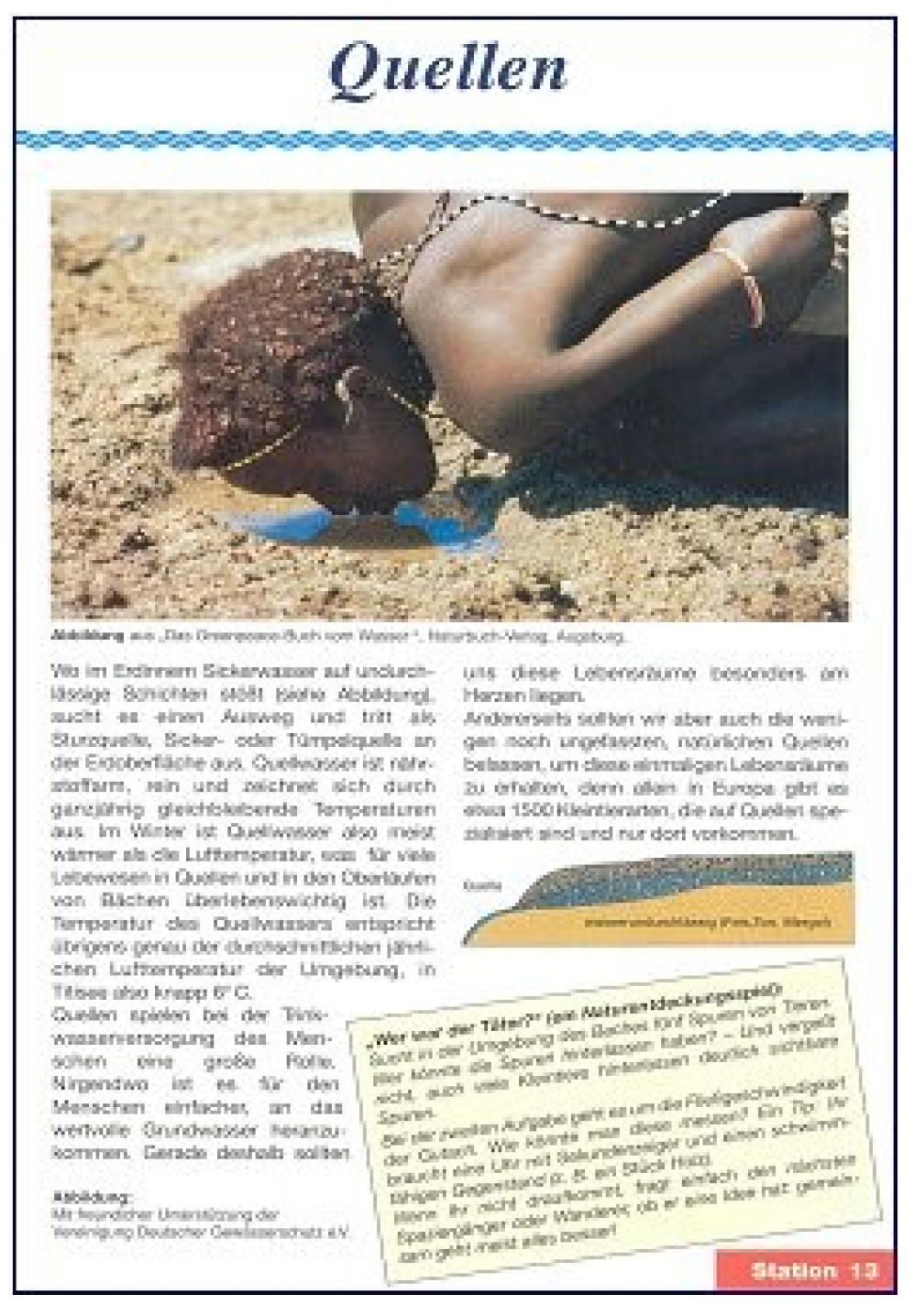
- Lack of regional reference (see Figure 9): A panel in Titisee-Neustadt (Black Forest) with textbook style knowledge on springs using a picture of another continent in a location where there is no spring.
- Lack of reference to the everyday world of visitors.
- Missing central idea and take-home message.
- Learning objectives (cognitive objectives) (“what should the visitor have learned after walking the trail?”—e.g., “springs are fascinating habitats worth protecting”),
- Behavioural objectives (“what behaviour should the visitor be taught?”—e.g., understanding and, ideally, commitment to protecting and preserving spring habitats).
- Emotional goals (“what should the visitor feel?”—e.g., perceive spring habitats as beautiful; enjoy being in nature).
2.4.3. Quality Criteria for Geotrails
- Provision of information in advance (e.g., via a website)
- Hassle-free journey through appropriate signposting as well as connection to public transport or sufficient parking spaces in the immediate vicinity
- Optimal routing, both in terms of the design of the paths and clear signposting, in other words, a person who is not familiar with the area will be able to find his way without any problems based on the information/signposting [74]. In general, natural, narrow and winding paths are preferred. However, this depends on the target group. For families with small children (strollers) and people with mobility impairments, other paths or small detour routes are necessary.
- Complementary tourist facilities and activities (rest and seating facilities, gastronomy, …)
- Consideration of the criteria of the heritage interpretation (see Section 2.3.1)
- Individual conception, no copies or standard elements, not even for activity stations.
- Clear target group definition, with texts and installations adapted to this; if necessary, new media
- Design of panels with interest-generating headlines, relatively limited text (note: Studies in Portugal showed that more than half of the visitors stayed for a maximum of one minute in front of a board the amount of text of which would have required four minutes to read. Only 3.4% actually stayed in front of the board for four minutes. Some individuals photographed the board without reading the text [75]) (if necessary divided into several information levels) (Figure 11), good visual material, if necessary graphics (for more information, see [16,53])
- Concrete regional reference including cross-references to flora, fauna, humans and the environment; if necessary, panels can also be exchanged seasonally in order to address different aspects and at the same time arouse interest [14]. For this purpose, choose optimal location areas where the respective phenomena can be easily seen
- Involvement of the visitors; interactivity, addressing different senses, not only purely receptive texts
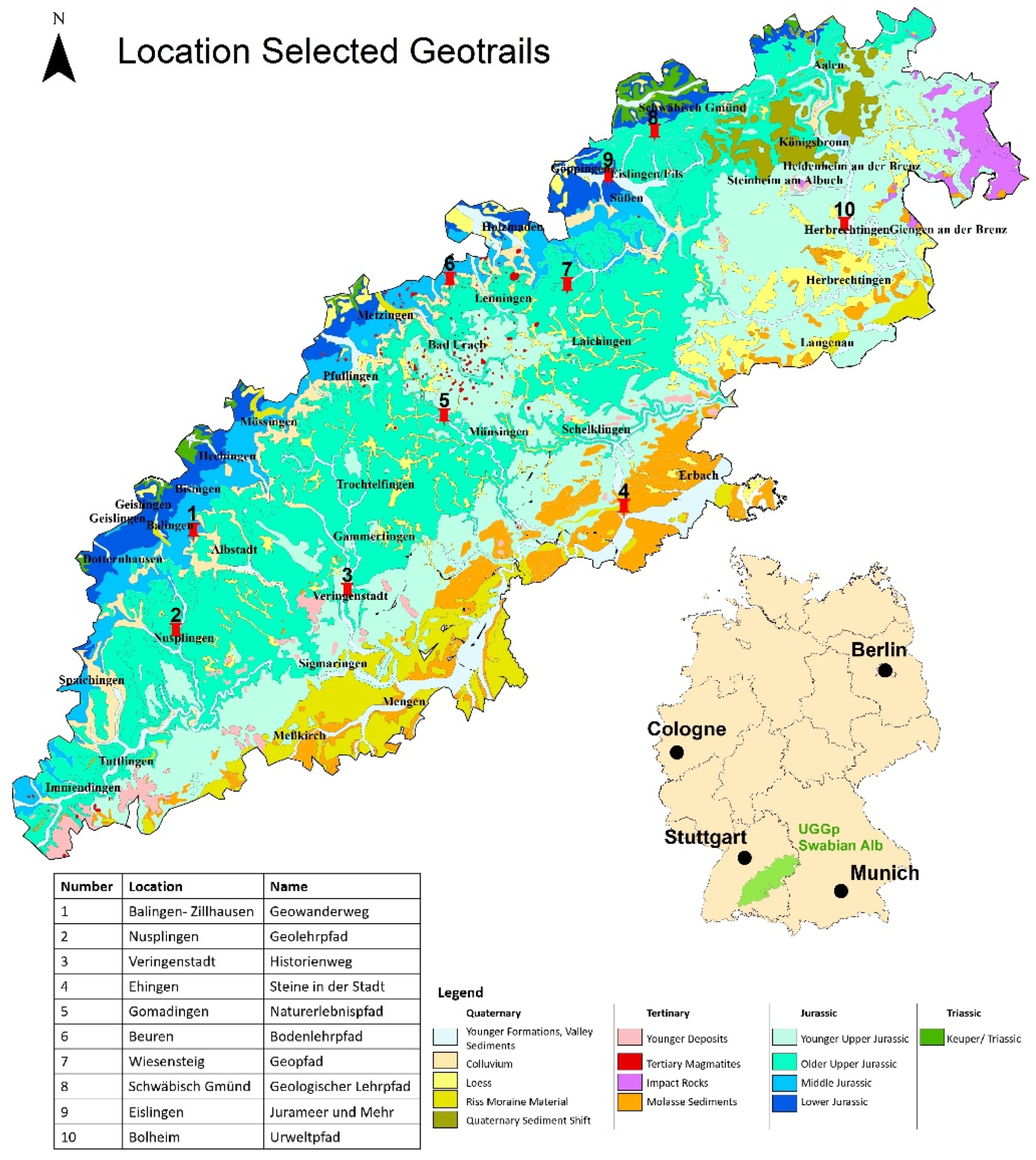
3. Study Area
4. Methodology

| Category | Criteria | Indicators | Notes | Examples |
|---|---|---|---|---|
| Concept and technologies | Individual concept | Individual tools | Specific, in-house concept, design and stations | Specific concepts are an essential quality feature and are mandatory for a well-founded interpretation and a touristic unique selling proposition |
| Individual design | ||||
| Individual stations | ||||
| New technologies | Use of QR codes | QR codes as a way of conveying information at different levels or in foreign languages | New technologies offer a wide range of possibilities for an expanded target group approach. The decisive factor is the problem-free functioning of the technologies | |
| Other new technologies | e.g., Apps, integration of smartphone functions, etc. | |||
| Information provision | Internet presence | Relevant information about the trail | Starting point, length, target group; content, infrastructure | Can visitors obtain full information in advance? |
| Homepage is visually appealing and arouses interest | A user-friendly homepage animates and stimulates interest | Is information easy to obtain; is interest aroused? | ||
| Information correct | Checking the correctness in the field | See Section 6: Complete path does not exist in reality | ||
| Flyer | Flyer downloadable in advance | Support for the preparation of the visit | e.g., directions to the site | |
| Available on site | Support for walking the trail | Reminder; take with you for follow up | ||
| Location | Beautiful surroundings | Aesthetic landscape | Promotes interest in visiting | Objectification through criteria from literature on landscape aesthetics |
| Surroundings well-maintained | Littered surroundings do not encourage visitors to visit | The main point of criticism from visitors at the Urach waterfall was the littering | ||
| Accessibility | Parking facilities | Parking facilities with no time limit in short distance | Arrival mainly by own car | |
| Public transport | Public transport stop a short distance away | Promoting public transport in the context of sustainability | ||
| Approach well marked with signposts | Clearly recognisable and unambiguous | Searching for the path is irritating. | ||
| Reference to time and place | Influence of the phenomenon on the environment as well as the environment on the phenomenon is conveyed | Essential criterion of landscape interpretation (s. ch. 2.3.1). | “The calcareous and perforated soil can cannot store rainwater well, which is why the soil is dry and nutrient-poor. As such, the meadows in the area could mostly only be cultivated as juniper heaths”. | |
| Local peculiarities are conveyed | Unique selling proposition, regional awareness | “Due to the volcanic ash present, the conditions for growing grapes are optimal. That is why there are so many wineries in the municipality.” | ||
| Temporal dimension is conveyed | Geological time spans are sometimes difficult for laypeople to understand | “If you imagine the life span of the Earth as one hour on the clock, we humans have only been extant for one second, whereas this stone has already existed for half an hour.” | ||
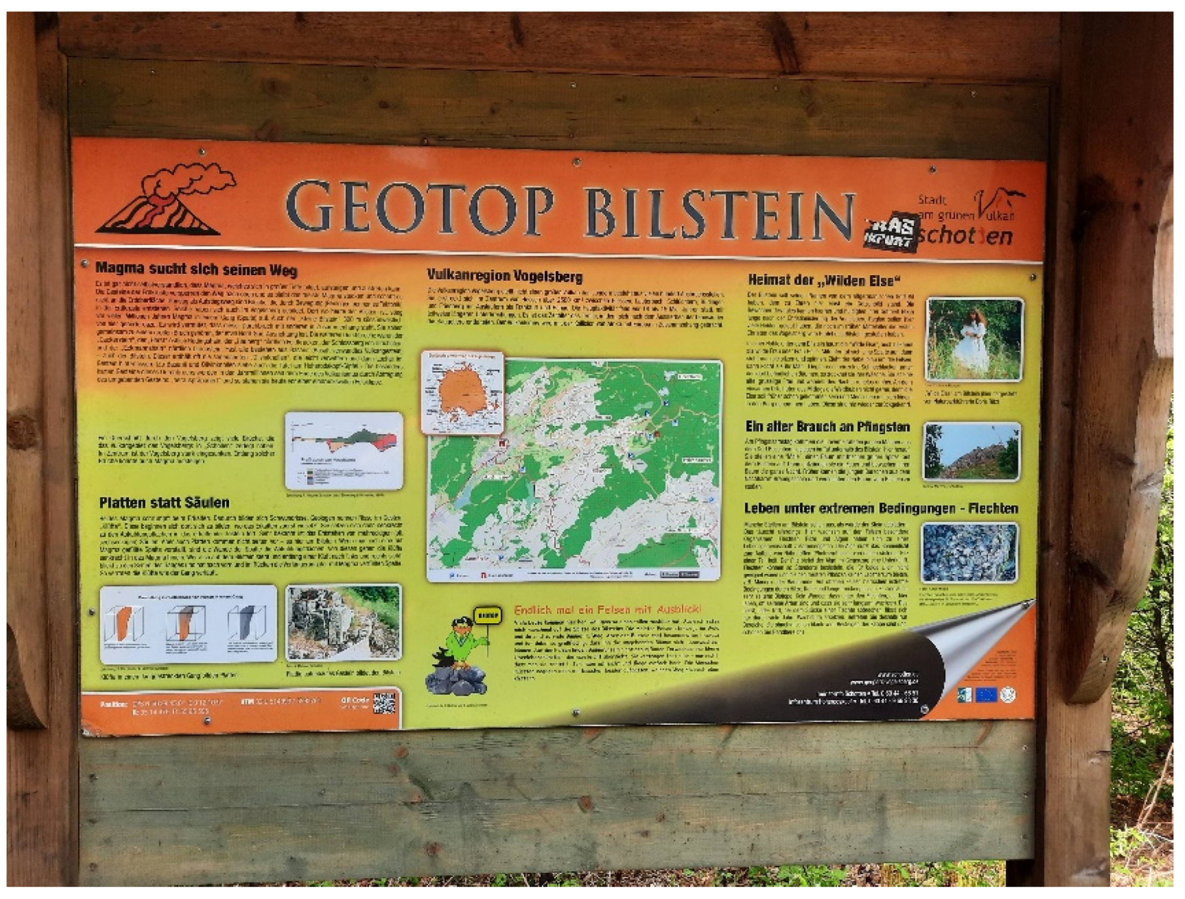
| The phenomenon can be experienced directly | Geotope directly on the path | Direct reference to the phenomenon is an essential criterion of landscape interpretation | Figure. 5 Information about the Bilstein Geotope (Vogelsberg National Geopark, Germany) directly on site. | |
| Safe environment | Crossing roads/rails | A trail should not cross any transport infrastructure if possible | The safety of visitors, especially children, is a fundamental aspect. In case of an emergency, the scene of the accident must be quickly accessible for the emergency services. | |
| Dangerous topography | Slopes, ravines, erosion hazard | |||
| Rescue points available | Mobile phone reception secured | |||
| Escape routes available | Accessibility for rescue vehicles | |||
| Tourist infrastructure | Other sights in the vicinity | Possibilities to extend the visit and combine it with other things | Increasing regional value creation | |
| Gastronomy in the vicinity | Important tourism aspects | |||
| Path structure | Entrance area | Entrance panel with relevant information available | Comparable to the internet presence, but crucial for spontaneous visits | Can visitors fully inform themselves before the start of the walk-through? |
| Recreational infrastructure available | Benches, etc. | Especially important for seniors | ||
| Other infrastructure in the vicinity | Information centre, museum, gastronomy | Combination of several tourist facilities and activities | ||
| Easy to find | Entrance area already visible or easy to find from the car park | Searching for the entrance area is demotivating | ||
| Path | Path design | Narrow, curved paths are preferable to asphalted forest paths | Wayfinding arouses interest, creates tension. | |
| Adequate length | In relation to the respective target group | Paths that are too short disappoint; paths that are too long demotivate | ||
| Rest and refreshment facilities on the trail | Possibilities for a break, picnic on the way | Particularly relevant for families with children and senior citizens | ||
| Circular route | Circular routes are to be preferred to long-distance routes. | Public transport or car park can be reached without any problems. | ||
| Output range | End of the path clearly recognisable | End clearly recognisable, e.g., by appropriate sign, numbering of stations, etc. | Clear information for the visitor | |
| Final panel | Unambiguity; possibility to clearly summarise what has been conveyed | Take home message | ||
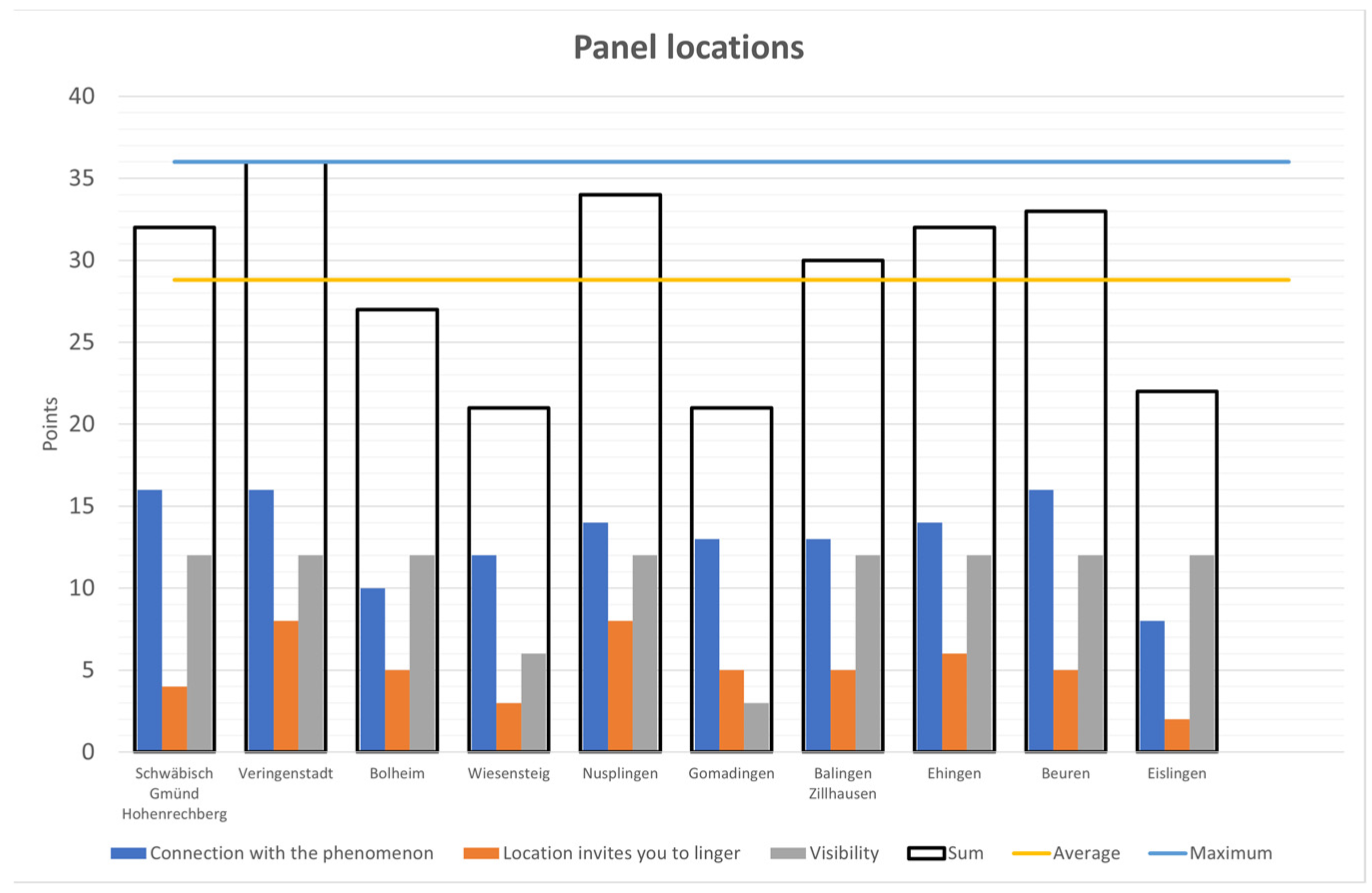
| Panel location | Connection with phenomenon | Phenomenon in visual relation to the panel | Smaller geotope in immediate vicinity; for landscape: relevant section visible | Essential criterion of landscape interpretation: concrete reference to concrete phenomenon (Figure 5) |
| Phenomenon recognisable | Even a lay audience can recognise the relevant phenomenon without problems. | Figure 4: The volcanic vent is not recognizable for a lay audience. | ||
| Location invites you to linger | Seating available; good standing position | A certain amount of time is needed for reading or for interactive elements. Is the location chosen in such a way that this is possible without, for example, obstructing other visitors? | Narrow paths or uneven terrain may not allow you to stay longer at a station. | |
| Aesthetic environment | Staying in a pleasant environment is preferred | See criterion “aesthetic landscape” at the beginning. | ||
| Visibility | Panel is visible and legible | Panel can be read without having to leave the path or decisively change the body posture | This also includes regular maintenance so that Information panels are not covered by vegetation, etc. | |
| Design | UGGp recognisable Corporate design | Recurring motifs/logos | Consistent use of recurring motifs/logos | A consistent graphic design creates a high recognition value; Logo can be used as an identification figure for children (see Figure 14). |
| Recurring colours and shapes | Consistent use to achieve a uniform impression | |||
| Structure of the signs/stations similar | Consistent structure and layout | |||
| Stations can be clearly assigned to the path | An important criterion specially in regions with different paths | |||
| Connection with Geopark recognisable | Logo of the Geopark present on the information panels | Increase awareness and identification with the Geopark | See Figure 5 with Logo of the Geopark. | |
| Colours and design inspired by the Geopark | Path design approximates the design of the Geopark. | Increase identification with the Geopark (see Figure 5) | ||
| Good graphical presentation | Colours harmonious | Consideration of colour theory; complementary colours are perceived as coherent. Colours harmonise with the surroundings without visually “disappearing”. | See Figure 11. | |
| Fonts coherent | Well-readable fonts that harmonise with each other and with the overall layout of the panel. | Ornate fonts are difficult to read, as are texts with only upper or lower case letters. The background also influences legibility (see Figure 15) | ||
| Good photos available | A picture is worth a thousand words, but only if appropriate and easily recognisable; too many pictures can be counterproductive. | Rocks etc. must be recognisable in detail on pictures so that even laypersons can recognise the necessary aspects, e.g., sedimentary structures, or mineral composition. | ||
| Good charts/graphics are available | Certain facts can be explained very well with graphics. These must be quick and easy to understand for laypersons. | Geological time spans can be well represented in graphs (see Figure 16) | ||
| Text readable from 2 m distance | Images and fonts chosen so that people with normal eyesight can easily read them. | Fonts or pictures that are too small have a demotivating effect. | ||
| Information | Amount of information suitable | Analogous to the target group, neither too much nor too little information | It is better to have several small information panels than one large overloaded panel. If necessary, additional information via QR code. | |
| Good balance between text and image | Texts and images complement each other more or less equally | In this way, information panels cater to different target groups. Reading readiness increases | ||
| Amount of information decreasing towards the end | Important information towards the front; attention wanes towards the end | |||
| Information scientifically correct | Information conveyed is simplified for lay people, but correct | This should be self-evident, but unfortunately it is not always the case, especially when a geotrail has been designed by people from outside the field. | ||
| Route guidance system | Consistent signage | Signposts easily recognisable and in uniform design | ||
| Not too many signs | A multitude of different signposts can confuse visitors | Quite common in tourist areas in Germany, as each hiking trail and path has its own signage. | ||
| Education | Activities arouse interest | Intrinsic motivation is awakened | It is crucial to arouse the interest of casual visitors in particular. | This can be done through unusual headlines, design, images, etc. |
| Direct experience | Different senses are addressed | The station offers not only purely receptive texts, but also appeals to several senses (e.g., hearing, touch, etc.). | In contrast to traditional nature trails, nature experience trails always work by appealing to different senses. | |
| Visitors are actively involved | Not just purely receptive texts, but invitations or installations to become active themselves. | Things are easily remembered when you actively take part. | ||
| Stimulates the visitors | Cognitive stimuli present | Visitors are mentally stimulated, e.g., suggestions to think about certain things | More intensive engagement with the subject matter | |
| Motor stimuli present | e.g., addressing the sense of balance; climbing, … | More intensive engagement e.g., with a particular geological formation | ||
| Integration of Education for Sustainable Development | At least one Sustainable Development Goal is addressed | ESD is one of the core tasks of the UGGp | ESD should enable people to think and act in a way that is fit for the future | |
| Aspects of sustainability and environmental protection are taught | UGGps are to be model regions for sustainable development. | Sustainability and environmental protection as a contribution to future viability | ||
| Visitors are encouraged to think for themselves | Pathway encourages people to look at specific issues, e.g., climate change and glacier melt. | Visitors should continue to engage with the respective topic even after their visit to the trail | ||
| Language | Good wording of the texts | Scientific-technical terms reduced in a way that is understandable for laypersons | Succeeds in presenting complex geoscientific aspects in a generally understandable way. Technical terms are explained | Extensive and incomprehensible technical vocabulary can repel visitors |
| Simple, understandable language | Box sentences and complicated formulations make it difficult to read and absorb the texts. | “The limestone layers in the lower part consist of approx. 4 m thick rock beds (oolites) with ooids up to 5 mm in size in the base sections, in which coarse and fine oolitic beds alternate” (Panel Geopark Harz). | ||
| Language at “eye level“ | Superior teacher-like formulations are usually met with rejection | “Keep this in mind!” “As you already know” | ||
| Geo-interpretation | Reference to everyday life is established | Relation of the phenomenon to the everyday world of the visitor | Are visitors and the phenomenon connected? | “In the past they would have used the “Stubensandstein” (Löwenstein Formation) as a cleaning agent; hence the unusual name” |
| Comparison of the phenomenon with everyday life | Complex issues are explained through comparisons. | The Grand Canyon is like a massive pancake pie or the rock layering is like a lasagne | ||
| Deeper meaning of the phenomenon is conveyed | Some things are not directly perceptible. | Reykjavik is the cleanest capital in the world, as it is almost 100% supplied with district heating from geothermal power plants. This is thanks to the active volcanism in Iceland. | ||
| Storytelling | Stations of the trail are connected by a story | The individual stations are elements of a story | The Feldberg Pixie-trail tells the story of Anton the Capercaillie. | |
| History is exciting | Visitors are interested in following the story further. | The Search for Anton the Capercaillie is not only exciting for children. | ||
| Horizon is broadened | Visitors experience new situations | The trail puts visitors in new situations or opens up other perspectives | Stimulating to walk barefoot over a boulder field or feel volcanic warmth. | |
| Visitors take a new perspective | The familiar is perceived differently | A mirror makes it possible to see things in a new way. | ||
| Connectedness with phenomenon is conveyed | Beauty/uniqueness of the phenomenon is conveyed | Visitors are made aware of uniqueness that they would otherwise not have noticed | Fossilised ripple marks in the Haute Provence Geopark. | |
| The phenomenon’s worthiness of protection is conveyed | Visitors are explicitly made aware of the need for protection. | Geological phenomena are often perceived as “stable”, whereas e.g., calcareous tuff formations are highly vulnerable [86]. | ||
| Various linguistic stylistic devices are used | Metaphors, comparisons, examples, analogies | Are linguistic means used that are suitable for conveying knowledge and feelings? | “Does the rock have sunburn?” Panel on the Rotliegend Group in Schramberg. | |
| Connections are shown | Connections between geopotentials, flora, fauna and people are shown | Does the path regularly show these connections? | e.g., fertile soils, good exposure, viticulture, regional economic value creation | |
| Central theme present | Orientation through central theme | “People forget facts, they remember themes” [43] | The Hainich—a primeval forest in the middle of Germany | |
| Connects the stations by a central theme | Can all stations be assigned to the main guiding idea? | Path to the Danube seepage near Tuttlingen | ||
| Captivates the audience | Main idea is well and concisely formulated | Trees are the lungs of the earth | ||
| Target group | Targeting the right audience | Clear focus on a target group | Is a specific target group named and is the pathway also designed accordingly? | Anton the Capercaillie—explicitly for families with children |
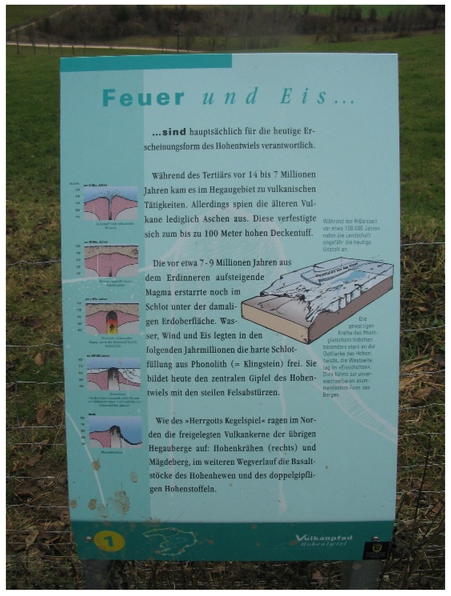
| Communication on several levels | To what extent is communication done on several levels, if applicable? | Hohentwiel Volcano Trail with main text and additional information (see Figure 11) | ||
| Language appropriate to the target group | Language of the audience | Is the language appropriate for the target group? | DinoPlagne (see Figure 16) Texts for adults and for children | |
| Multilingualism | If information is communicated in several languages | DinoPlagne (see Figure 16) or via QR codes | ||
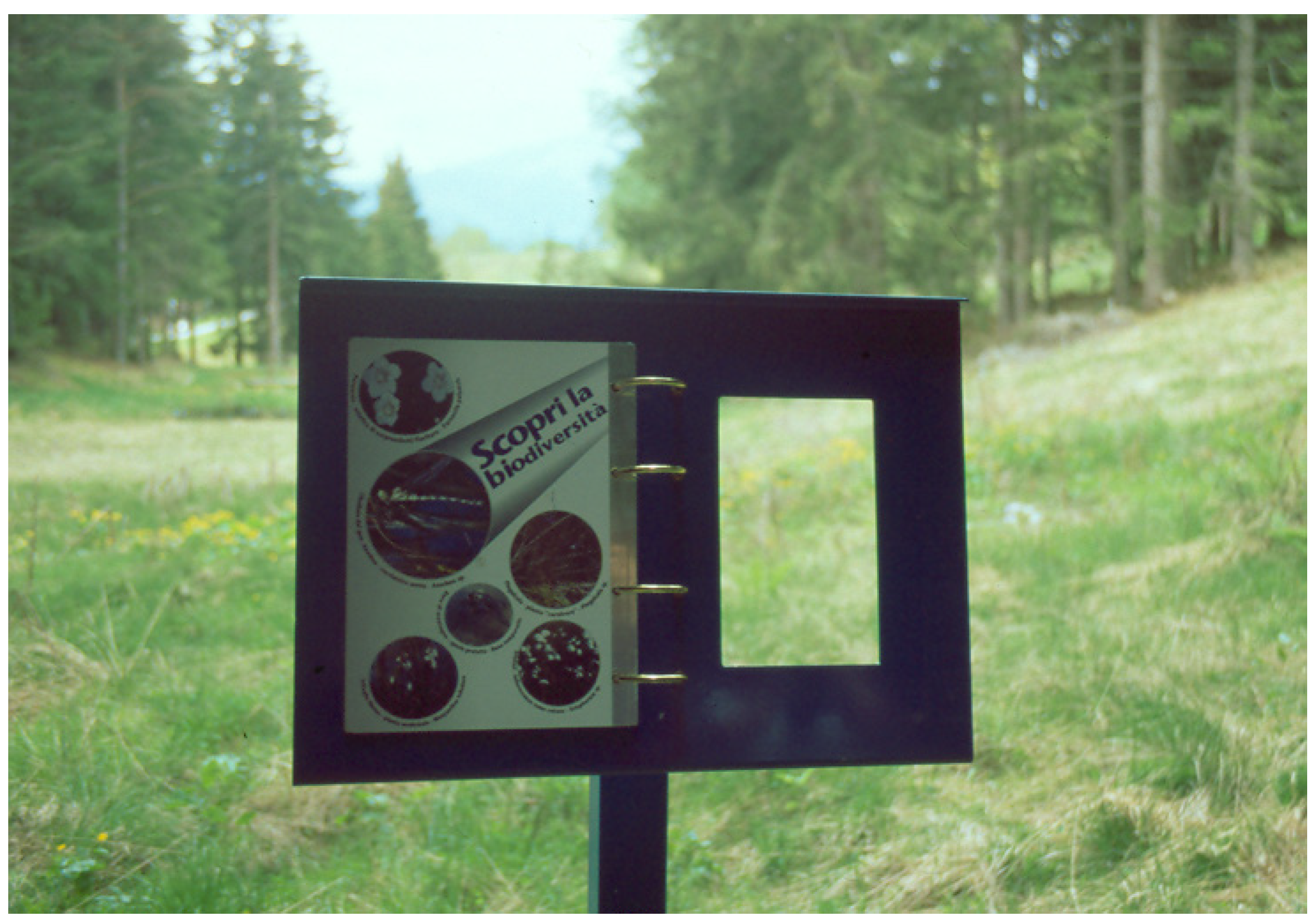
| Child-friendly design | Elements within reach for children | Can a primary school child operate the installations? | Stockach Spring Experience Trail (see Figure 8): Installations clearly too high. | |
| Information panels readable for children | Child-friendly texts and positioning | Integration of the term “Messages” on a German trail for families with children. Not understandable for children. | ||
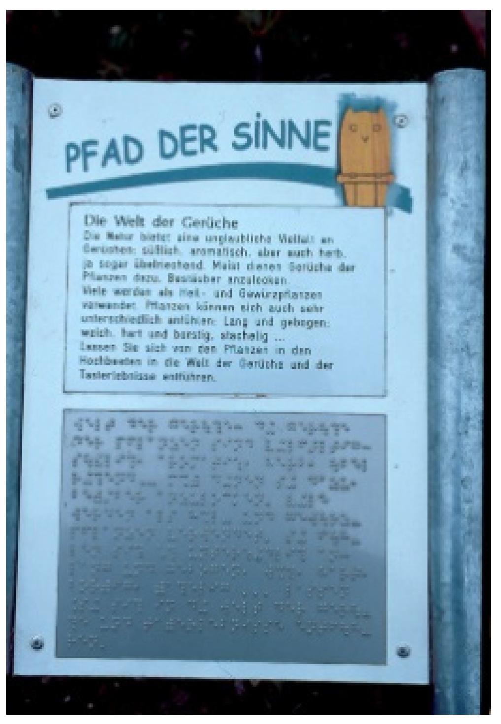
| Accessibility | Path accessible to all | The visually impaired and those with learning difficulties are also taken into account. | Path of the Senses in Reutlingen with Braille (see Figure 17) | |
| Path suitable for wheelchairs and prams | Have paths been chosen that are accessible to prams? | If necessary, two pathways (see Figure 14) | ||
| Geotope protection | Maintained geotopes | Geotopes are kept free of vegetation | This concerns both the geotope itself and the access route. | Some geotopes are no longer easily accessible or recognisable for visitors due to overgrowth. |
| No littering | This also includes how waste disposal is organised; are there rubbish bins; are there approaches such as “take the memories with you and also the rubbish”? | Hollow forms (sinkholes, etc.) in particular are sometimes filled with rubbish or excavated earth. | ||
| Geotopes are accessible | Can visitors easily get close enough to the geotope to see details | Mineral inclusions or fossils are sometimes only visible at close range | ||
| Geotopes are protected | Barriers are available if necessary | If barriers are necessary, near-natural materials (wood) are rated better than non-natural materials. | Barriers may be necessary, but can look very unsightly. | |
| Signs, if necessary prohibition signs available | Are the visitors informed about the reason for the barrier? | Explanations for barriers increase the understanding for such measures. | ||
| Sustainability/Maintenance | Care of the wards | Stations in good condition | Are all stations and information panels routinely maintained? | Broken stations and faded information panels are extremely counterproductive. |
| Information panels in good condition | ||||
| Stations protected from the weather | Was care taken in advance to protect or position the stations well? | Sun-exposed information panels fade more quickly. Leaves or snow may remain on sloping information panels. | ||
| Robust materials | Robust stations | Were materials used that last and are stable in the long term? | Robust materials are more sustainable in the long term as less replacement is required. Information panels still in good condition after twenty years. | |
| Robust information panels | ||||
| Robust signposts | ||||
| No vandalism | Is there any damage, graffiti or similar? | Signs of vandalism can be an indication of non-regular monitoring | ||
| Road safety | Paths not overgrown | The safety of visitors must be ensured; at the same time, branches on the paths, etc. are an indication of inadequate maintenance | See Figure 18. With such obstacles, a path can no longer be used. | |
| No logs/branches on the path | ||||
| Slopes secured; railings or bridge available if necessary | ||||
| Support from other actors | Support through an association | If associations or the community support and maintain the path, this speaks for a high level of identification. | The Barefoot Trail near Freudenstadt is walked daily by a pensioner to guarantee the safety of the path. | |
| Support from a municipality | ||||
| Sponsorships or similar | ||||
| Funding | Sponsoring | Does the path receive funding, not only for concept and construction, but also for ongoing maintenance? | The History Trail in Veringenstadt could only be financed thanks to funding from the Upper Danube Nature Park. | |
| Funding, e.g., EU programmes | ||||
| Donation box or similar | ||||
| Visitor feedback | Feedback box on site | Feedback from visitors is essential for path management and should therefore be easily accessible. | Unfortunately, examples of this are rare. Mostly, points of criticism tend to be posted on corresponding internet forums in general. | |
| Feedback options via homepage |
5. Evaluation of Existing Pathways in the UGGp Swabian Alb.
5.1. Definition, Survey and Selection of the Investigated Geotrails
- The Nusplingen Geological Nature Trail
- The Zillhauser Waterfall Geological Hiking Trail
- The Veringenstadt History Trail
- The Schwäbisch Gmünd Geological Trail
5.2. List of Criteria for the Evaluation of Geotrails
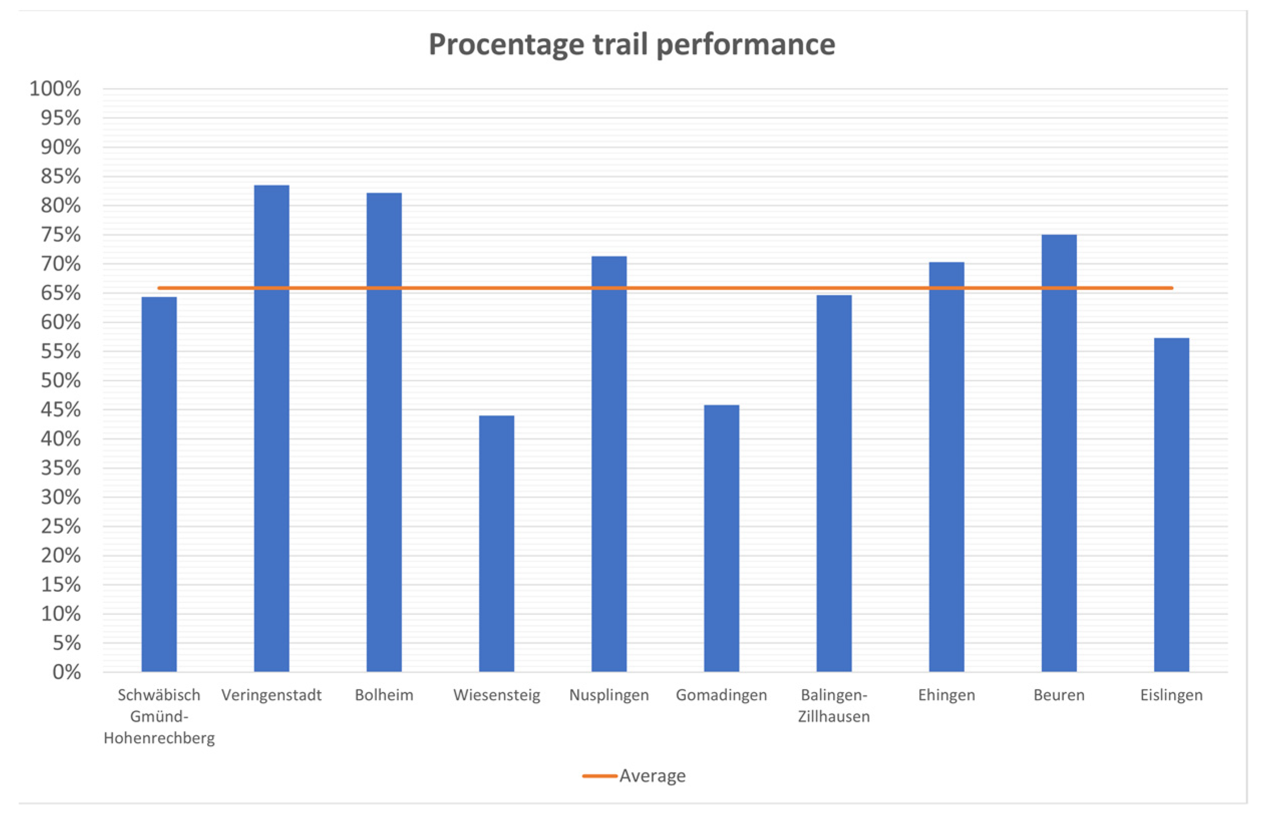
6. Results of the Evaluation of the Geotrails in the UGGp Swabian Alb
6.1. Discussion of the Results
6.2. Outlook and Further Research
Author Contributions
Funding
Acknowledgments
Conflicts of Interest
References
- Hose, T. Geotourism: Appreciating the deep time of landscapes. In Niche Tourism: Contemporary Issues, Trends and Cases; Novelli, M., Ed.; Routledge: London, UK, 2004; pp. 27–37. ISBN 978-0750661331. [Google Scholar]
- Dowling, R.K.; Newsome, D. Handbook of Geotourism; Edward Elgar Publishing: Cheltenham, UK, 2018; ISBN 1785368850. [Google Scholar]
- Newsome, D.; Dowling, R.K. Geoheritage and Geotourism. In Geoheritage: Assessment, Protection, and Management; Reynard, E., Brilha, J.B., Eds.; Elsevier: Amsterdam, The Netherlands, 2018; pp. 305–321. ISBN 9780128095317. [Google Scholar]
- Dowling, R.K.; Newsome, D. Geotourism: The Tourism of Geology and Landscape; Goodfellow Publishers: Woodeaton, Oxford, UK, 2010; ISBN 978-1906884093. [Google Scholar]
- Reynard, E.; Brilha, J.B. (Eds.) Geoheritage: Assessment, Protection, and Management; Elsevier: Amsterdam, The Netherlands, 2018; ISBN 9780128095317. [Google Scholar]
- Chen, A.; Lu, Y.; Ng, Y.C.Y. The Principles of Geotourism; Springer: Heidelberg, Germany, 2015; ISBN 978-3-662-46696-4. [Google Scholar]
- Megerle, H. Geotourismus. Innnovative Ansätze zur Touristischen Inwertsetzung und Nachhaltigen Regionalentwicklung; Kersting-Verlag: Rottenburg am Neckar, Germany, 2008. [Google Scholar]
- Ólafsdóttir, R. Geotourism. Geosciences 2019, 9, 48. [Google Scholar] [CrossRef]
- Singh, R.B.; Wei, D.; Anand, S. (Eds.) Global Geographical Heritage, Geoparks and Geotourism: Geoconservation and Development; Springer: Singapore, 2021; ISBN 978-981-15-4955-7. [Google Scholar]
- Brilha, J.B. Geoheritage and Geoparks. In Geoheritage: Assessment, Protection, and Management; Reynard, E., Brilha, J.B., Eds.; Elsevier: Amsterdam, The Netherlands, 2018; pp. 323–335. ISBN 9780128095317. [Google Scholar]
- UNESCO. UNESCO Global Geoparks. Available online: https://en.unesco.org/global-geoparks (accessed on 27 May 2022).
- European Geoparks Network. Geoparks. Available online: http://www.europeangeoparks.org/?lang=de (accessed on 9 March 2022).
- UNESCO. Statutes of the International Geoscience and Geoparks Programme and Operational Guidelines for UNESCO Global Geoparks, Paris. 2015. Available online: https://unesdoc.unesco.org/ark:/48223/pf0000380991 (accessed on 1 July 2022).
- Hose, T.A. Geotrails. In The Geotourism Industry in the 21st Century: The Origin, Principles, and Futuristic Approach, 1st ed.; Sadry, B.N., Ed.; Apple Academic Press: New York, NY, USA, 2020; pp. 247–275. ISBN 9780429292798. [Google Scholar]
- Aufenanger, J. Evaluation Nationaler GeoParks—Zur Attraktivität von Geoparks und ihrer Bedeutung für den Geotourismus; Johannes Gutenberg-Universität Mainz: Mainz, Germany, 2020. [Google Scholar]
- Megerle, H. Naturerlebnispfade—Neue Medien der Umweltbildung und des landschaftsbezogenen Tourismus? Bestandsanalyse, Evaluation und Entwicklung von Qualitätsstandards; Geographisches Institut der Universität Tübingen: Tübingen, Germany, 2003; ISBN 3-88121-035-0. [Google Scholar]
- Megerle, H. One Billion Years of Earth History: Challenges of Valorizing the Outstanding Geodiversity of Southwest Germany for Sustainable Geotourism. Sustainability 2022, 14, 559. [Google Scholar] [CrossRef]
- Hose, T.A. Selling the Story of Britain’s Stone. Environ. Interpret. 1995, 10, 16–17. [Google Scholar]
- Hose, T.A. European Geotourism: Geological Interpretation and Geoconservation Promotion for Tourists. In Geological Heritage: Its Conservation and Management; Barettino, D., Wimbledon, W.A., Gallego, E., Eds.; Instituto Geológico y Minero de España: Madrid, Spain, 2000; pp. 127–146. ISBN 84-7840-417-1. [Google Scholar]
- Frey, M.-L. Geologie—Geotourismus—Umweltbildung: Themen-und Tätigkeitsbereiche im Spannungsfeld Ökonomie und Nachhaltige Entwicklung. In Geo-Berlin 1998: Programm und Zusammenfassung der Tagungsbeiträge, Berlin, Germany, 6–9 October; Schriften der GeoUnion Alfred-Wegener-Stiftung: Potsdam, Germany, 1998; Volume 85. [Google Scholar]
- Hose, T.A. 3G’s for Modern Geotourism. Geoheritage 2012, 4, 7–24. [Google Scholar] [CrossRef]
- National Geographic. Geotourism. Available online: https://www.nationalgeographic.com/maps/topic/geotourism (accessed on 27 May 2022).
- McKeever, P.J.; Zouros, N.C.; Patzak, M. The UNESCO Global Network of National Geoparks. Georg. Wright Forum 2010, 27, 14–18. [Google Scholar]
- Bétard, F. Géodiversité, Biodiversité et Patrimoines Environnementaux. De la Connaissance à la Conservation et à la Valorization; Mémoire d’Habilitation à Diriger des Recherches; Université Sorbonne Paris Cité: Paris, France, 2017. [Google Scholar]
- Girault, Y. Les Géoparcs Mondiaux UNESCO: Une Mise en Tension Entre Développement des Territoires et Mise en Valeur du Patrimoine; ISTE Editions: London, UK, 2019; ISBN 978-1-78405-562-2. [Google Scholar]
- Geo-Union Alfred-Wegener-Stiftung. Nationaler Geopark. Available online: https://www.nationalgeographic.com/maps/topic/geotourism (accessed on 8 February 2022).
- Zafeiropoulos, G.; Drinia, H.; Antonarakou, A.; Zouros, N. From Geoheritage to Geoeducation, Geoethics and Geotourism: A Critical Evaluation of the Greek Region. Geosciences 2021, 11, 381. [Google Scholar] [CrossRef]
- Bauer, U.C. “Geo” erlebbar machen. STANDORT-Z Angew. Geogr. 2008, 32, 128–131. [Google Scholar] [CrossRef]
- Silva, E.; Weber, J. European Global Geoparks: Effective Contribution for the Achievement of the SDGs. In Proceedings of the 8th International Conference on UNESCO Global Geoparks, Adamello Brenta UNESCO Global Geopark, Madonna di Campiglio, Italy, 11–14 September 2018. [Google Scholar]
- Catana, M.M.; Brilha, J.B. The Role of UNESCO Global Geoparks in Promoting Geosciences Education for Sustainability. Geoheritage 2020, 12, 1. [Google Scholar] [CrossRef]
- Stoffelen, A. Where is the community in geoparks? A systematic literature review and call for attention to the societal embedding of geoparks. Area 2020, 52, 97–104. [Google Scholar] [CrossRef]
- Giusti, C. Introduction to the thematic issue. “From Geosites to Geomorphosites: How to decode the landscape? Geodynamic processes, surficial features and landforms, past and present environments”. Geomorphologie 2010, 16, 123–130. [Google Scholar] [CrossRef]
- Frey, M.-L. 15 Jahre Geotourismus—Ansätze, Erfolge, Perspektiven. In Geowissenschaften und Öffentlichkeit. 6. Internationale Tagung der Fachsektion GEOTop der Deutschen Geologischen Gesellschaft, Viechtach/Bayer, 10 April 2002; Kruhl, J.H., Birkenhauer, J., Lagally, U., Lehrberger, G., Eds.; Dt. Geologische Ges: Hannover, Germany, 2003; pp. 24–27. ISBN 3-932537-00-9. [Google Scholar]
- Wölfl, C. Grundlagen für die Planung geodidaktischer Angebote. In Geotope—Bausteine der Regionalentwicklung: 23—26. Mai 2006 in Ulm; Rosendahl, W., Junker, B., Megerle, A., Vogt, J., Lange, J.M., Röhling, H.G., Eds.; Deutsche Gesellschaft für Geowissenschaften: Hannover, Germany, 2006; pp. 82–86. ISBN 9783932537400. [Google Scholar]
- Megerle, H.; Martin, S.; Regolini, G. Chancen, Herausforderungen und Risiken der Inwertsetzung des regionalen Geo-Erbes: Geotopschutz und Geotourismus im Spannungsfeld unterschiedlichster Interessen. Geogr. Helv. 2022, 77, 53–66. [Google Scholar] [CrossRef]
- Martin, S.; Regolini-Bissig, G. Élaborer et évaluer des produits géotouristiques: L’approche globale de la médiation. Espaces 2013, 315, 112–121. [Google Scholar]
- Megerle, H. Landschaftsinterpretation und erlebnispädagogische Elemente als neue Ansätze zur Förderung der Umweltbildung und des Umwelthandelns. In GrenzWerte, Tagungsbericht und Wissenschaftliche Abhandlungen 55. Deutscher Geographentag Trier 2005, 1. bis 8. Oktober 2005 Im Auftrag der Deutschen Gesellschaft für Geographie (DGfG); Kulke, E., Monheim, H., Wittmann, P., Eds.; Deutsche Gesellschaft für Geographie (DGfG): Berlin, Germany, 2006; ISBN 9783980875424. [Google Scholar]
- Martin, S. De la diversité des publics concernés. In Guide Pratique de Valorisation des Géomorphosites, 1st ed.; Cayla, N., Ambert, M., Eds.; Presses Universitaires Savoie Mont Blanc: Chambéry, France, 2020; pp. 12–24. ISBN 9782377410460. [Google Scholar]
- Clement, T. Korallen, Maare, Mineralwasser—das geotouristische Angebot in der Vulkaneifel. In Geotourismus: Innovative Ansätze zur Touristischen Inwertsetzung und Nachhaltigen Regionalentwicklung, 2nd ed.; Megerle, H., Ed.; Kersting: Rottenburg am Neckar, Germany, 2008; pp. 185–192. ISBN 9783937559148. [Google Scholar]
- Cayla, N.; Ambert, M. (Eds.) Guide Pratique de Valorisation des Géomorphosites, 1st ed.; Presses Universitaires Savoie Mont Blanc: Chambéry, France, 2020; ISBN 9782377410460. [Google Scholar]
- Moscardo, G. Making Visitors Mindful: Principles for Creating Quality Sustainable Visitor Experiences through Effective Communication; Sagamore Publishing: Champaign, IL, USA, 1999; ISBN 9781571672599. [Google Scholar]
- Tilden, F. Interpreting our Heritage: Principles and Practices for Visitor Services in Parks, Museums, and Historic Places; University of North Carolina Press: Chapel Hill, NC, USA, 1967; ISBN 0-8078-4016-5. [Google Scholar]
- Ham, S.H. Environmental Interpretation: A Practical Guide for People with Big Ideas and Small Budgets; Fulcrum Publishing: Golden, CO, USA, 1992; ISBN 9781555919023. [Google Scholar]
- Beck, L.; Cable, T.T. Interpretation for the 21st: Fifteen Guiding Principles for Interpreting Nature and Culture, 2nd ed.; Sagamore Publishing: Champaign, IL, USA, 2002; ISBN 1571675221. [Google Scholar]
- Crofts, R.; Gordon, J.E.; Brilha, J.; Gray, M.; Gunn, J.; Larwood, J.; Santucci, V.; Tormey, D.; Worboys, G.L.; Groves, C. Guidelines for Geoconservation in Protected and Conserved Areas: Best Practise Protected Area Guidelines; IUCN, International Union for Conservation of Nature: Gland, Switzerland, 2020; ISBN 9782831720791. [Google Scholar]
- Serrell, B. Exhibit Labels: An Interpretive Approach, 2nd ed.; Rowman & Littlefield: Lanham, MD, USA, 2015; ISBN 978-1442249035. [Google Scholar]
- Moscardo, G.; Ballantyne, R.; Hughes, K. Designing Interpretive Signs: Principles in Practice; Fulcrum Publishing: Golden, CO, USA, 2007; ISBN 978-1555915506. [Google Scholar]
- Badoux, A.; Graf, C.; Rhyner, J.; Kuntner, R.; McArdell, B.W. A debris-flow alarm system for the Alpine Illgraben catchment: Design and performance. Nat. Hazards 2009, 49, 517–539. [Google Scholar] [CrossRef] [Green Version]
- Fehn, K.; Kleefeld, K. Die Verbindung von Natur- und Kulturerleben: Der Betrachtungsansatz der ganzheitlich historisch-geographischen Kulturlandschaftspflege. In Naturerfahrungsräume: Ein Humanökologischer Ansatz Für Naturnahe Erholung in Stadt und Land; Ergebnisse aus dem F+E Vorhaben 80806009 des Bundesamtes für Naturschutz; Schemel, H.-J., Ed.; Landwirt-schaftsverl: Bonn-Bad Godesberg, Germany, 1998; pp. 191–206. ISBN 978-3896243157. [Google Scholar]
- Megerle, H. Geoheritage and Geotourism in Regions with Extinct Volcanism in Germany: Case Study Southwest Germany with UNESCO Global Geopark Swabian Alb. Geosciences 2020, 10, 445. [Google Scholar] [CrossRef]
- Ballstaedt, S.-P. Richtlinien zur Gestaltung von Lehrtexten Reihe: Werkstattbericht Nr 2; Deutsches Institut für Fernstudien an der Universität Tübingen: Tübingen, Germany, 1993. [Google Scholar]
- Ibetsberger, H.; Feitzinger, G. UNESCO-Geopark Erz der Alpen. In UNESCO-Geoparke in Östereich: Natur- und Kulturerlebnisführer der Universität Salzburg, 1st ed.; Hejl, E., Ibetsberger, H., Steyrer, H., Eds.; Verlag Dr. Friedrich Pfeil: München, Germany, 2017; pp. 8–46. ISBN 978-3-89937-182-6. [Google Scholar]
- Prendivoj, S. Tailoring Signs to Engage Two Distinct Types of Geotourists to Geological Sites. Geosciences 2018, 8, 329. [Google Scholar] [CrossRef]
- Megerle, H. Geo-Erbe: Geotourismus, Geotopschutz, Geodiversität, Geobildung; Springer: Berlin/Heidelberg, Germany, 2022; in preprint. [Google Scholar]
- Ebers, S.; Laux, L.; Kochanek, H.-M. Vom Lehrpfad zum Erlebnispfad: Handbuch für Naturerlebnispfade, 1st ed.; NZH: Wetzlar, Germany, 1998; ISBN 9783926871336. [Google Scholar]
- Meyer, D. Geologische Aufschlüsse, Naturdenkmale und Lehrpfade—Ihre Bedeutung für die Gesellschaft. In Geowissenschaften als Gesellschaftliche Aufgabe. Festschrift zum 60. Geburtstag von Peter Neumann-Mahlkau; Hilden, H.D., Peter Meiburg, Eds.; Schweizerbart Science Publishers: Stuttgart, Germany, 1996; pp. 5–34. ISBN 9783510963522. [Google Scholar]
- Eder, R.; Arnberger, A. Lehrpfade—Natur und Kultur auf dem Weg: Lehrpfade, Erlebnis- und Themenwege in Österreich; Böhlau: Wien, Austria; Köln/Weimar, Germany, 2007; ISBN 9783205775911. [Google Scholar]
- Spanish UNESCO Global Geoparks. Bizi-Vive-Experience Geoparks: Brochure. Available online: https://geoparkea.eus/site_media/pdf/GEOPARQUES_2019.pdf (accessed on 1 July 2022).
- Dowling, R.K. Geotourism’s Global Growth. Geoheritage 2011, 3, 1–13. [Google Scholar] [CrossRef]
- Saddiqi, O.; Rjimati, E.; Michard, A.; Soulaimani, A.; Ouanaimi, H. Recommended geoheritage trails in Southern Morocco: A 3 Ga record between the Sahara Desert and the Atlantic Ocean. In From Geoheritage to Geoparks: Case Studies from Africa and Beyond; Errami, E., Brocx, M., Semeniuk, V., Eds.; Springer: Cham, Switzerland, 2015; pp. 91–108. ISBN 978-3-319-10707-3. [Google Scholar]
- Parc Naturel Régional du Massif des Bauges. Geoparc de Bauges—La Spéléorando. Available online: https://www.parcdesbauges.com/fr/decouvrir-le-massif-des-bauges/bouger/se-rafraichir/peche/speleorando-670087.html#.YrLftHZBxRY (accessed on 22 June 2022).
- Megerle, H. One decade of successful geosite management in the Northern Black Forest Nature Reserve: A long-term study on the spa town of Bad Herrenalb. In Gestion des Géosites Dans les Espaces Protégés; Hoblea, F., Cayla, N., Reynard, E., Eds.; Laboratoire EDYTEM, Université de Savoie: Chambéry, France, 2013; pp. 105–108. ISBN 978-2918435075. [Google Scholar]
- Grieshammer, K. Evaluierung von Lehrpfaden im Naturpark Altmühltal: “Konventionelle” Lehrpfade und Konzeptionelle Neuansätze. Diploma’s Thesis, Faculty of Mathematics and Geography, Eichstätt, Germany, 1999. Unpublished. [Google Scholar]
- Megerle, A. Landschaftsmarketing als Baustein für einen zukunftsfähigen Albtourismus. In Wirtschaftswunder Schwäbische Alb! Naturpotential als Chance für den Ländlichen Raum, Tagung am 20. November 1998, Geographisches Institut der Eberhard-Karls-Universität Tübingen. Wirtschaftswunder Schwäbische Alb! Naturpotential als Chance für den Ländlichen Raum, Geographisches Institut der Eberhard-Karls-Universität Tübingen, 20 November 1998; Eberhard Karls Universität Tübingen Geographisches Institut, Naturschutzbund Deutschland Landesverband Baden-Württemberg, Eds.; Landesverband Baden-Württemberg; NABU: Stuttgart, Germany, 1998; pp. 37–53. [Google Scholar]
- Ebers, S. Lehrpfadsituation in Deutschland: Entwicklung, Ist-Zustand, Neue Ansätze; NZH-Verlag: Leverkusen, Germany, 1996. [Google Scholar]
- Laux, L. Vom “Lehr-Pfad” zum Erlebnispfad. In Grenzgänge: Umweltbildung und Ökotourismus; Forum Umweltbildung, Ed.; Forum Umweltbildung: Wien, Austria, 2002; pp. 24–27. ISBN 3-900717-47-8. [Google Scholar]
- Eder, R.; Arnberger, A. Geologie am Weg: Anregungen zur Gestaltung von Geotrails. In Geotope: Dialog Zwischen Stadt und Land; Hofmann, T., Ed.; Deutsche Gesellschaft für Geowissenschaften: Hannover, Germany, 2007; pp. 29–34. ISBN 9783932537493. [Google Scholar]
- Lang, C.; Stark, W. (Eds.) Schritt für Schritt NaturErleben: Ein Wegweiser zur Errichtung moderner Lehrpfade und Erlebniswege; Forum Umweltbildung: Wien, Austria, 2000; ISBN 978-3900717421. [Google Scholar]
- Veverka, J.A. Interpretive Master Planning; Acorn Naturalists: Tustin, CA, USA, 1998; ISBN 9781881150015. [Google Scholar]
- Lehnes, P. Lehr-, Erlebnis- und Themenpfade-Handbuch; Druckerei Sikora: Offenburg, Germany, 2006. [Google Scholar]
- Cayla, N.; Martin, S. Digital Geovisualisation Technologies Applied to Geoheritage Management. In Geoheritage: Assessment, Protection, and Management; Reynard, E., Brilha, J.B., Eds.; Elsevier: Amsterdam, The Netherlands, 2018; pp. 289–303. ISBN 9780128095317. [Google Scholar]
- Veverka, J.A. Exhibit evaluation for Children’s Exhibits: The Kirby Science Center Experience. Available online: http://www.heritageinterp.com/newpage13.htm (accessed on 24 June 2022).
- Megerle, H. (Ed.) Geotourismus: Innovative Ansätze zur Touristischen Inwertsetzung und Nachhaltigen Regionalentwicklung, 2nd ed.; Kersting: Rottenburg am Neckar, Germany, 2008; ISBN 9783937559148. [Google Scholar]
- Macadam, J. Geoheritage: Getting the message across. What message and to whom? In Geoheritage: Assessment, Protection, and Management; Reynard, E., Brilha, J.B., Eds.; Elsevier: Amsterdam, The Netherlands, 2018; pp. 267–288. ISBN 9780128095317. [Google Scholar]
- Lima, A.; Nunes, J.C.; Brilha, J. Monitoring of the Visitors Impact at “Ponta da Ferraria e Pico das Camarinhas” Geosite (São Miguel Island, Azores UNESCO Global Geopark, Portugal). Geoheritage 2017, 9, 495–503. [Google Scholar] [CrossRef]
- Lehnes, P. Mehr als nur schön. Professionelle Landschaftsinterpretation zur Förderung des nachhaltigen Tourismus im Südschwarzwald. In Grenzgänge: Umweltbildung und Ökotourismus; Forum Umweltbildung, Ed.; Forum Umweltbildung: Wien, Austria, 2002; pp. 31–35. ISBN 3-900717-47-8. [Google Scholar]
- Martin, S. Valoriser le Géopatrimoine par la Médiation Indirecte et la Visualisation des Objets Géomorphologiques; Université de Lausanne, Institut de Géographie: Lausanne, Switzerland, 2013; ISBN 978-2-940368-17-4. [Google Scholar]
- Cayla, N. Le Patrimoine Géologique de L’ARC Alpin: De la Médiation Scientifique à la Valorisation Géotouristique. Thèse de Doctorat en Sciences de la Terre, de l’univers et de L’environnement; Université de Savoie: Chambéry, France, 2009. [Google Scholar]
- Geyer, O.F.; Gwinner, M.P.; Geyer, M.; Nitsch, E.; Simon, T.; Ellwanger, D. Geologie von Baden-Württemberg, 5th ed.; Schweizerbart: Stuttgart, Germany, 2011; ISBN 9783510652679. [Google Scholar]
- Hochschule für Forstwirtschaft Rottenburg; SWOT-Analyse für den UNESCO Global Geopark Schwäbische Alb: Rottenburg, Germany, 2021.
- Huth, T.; Junker, B. Geotouristische Karte Nationaler Geopark Schwäbische Alb mit Umgebung 1: 200,000: Erläuterungen; REIFF DRUCK: München, Germany, 2003. [Google Scholar]
- Geopark Schwäbische Alb. UNESCO Global Geopark Schwäbische Alb. Available online: https://geopark-alb.de/de/ (accessed on 22 June 2022).
- Geopark Schwäbische Alb. Entdeckerkarte. Available online: https://geopark-alb.de/pdf/Geopark_Broschueren/2021/Geopark-Entdeckerkarte2021.pdf?m=1616570490& (accessed on 22 June 2022).
- Beck, L.; Cable, T.T. Interpretation for the 21st Century, Fifteen Guiding Principles for Interpreting Nature and Culture, 1st ed.; Sagamore Publishing: Champaign, IL, USA, 1998. [Google Scholar]
- Ludwig, T. Kurshandbuch Natur- und Kulturinterpretation; Gicom Buchdruck: Borgentreich, Germany, 2008. [Google Scholar]
- Megerle, H. Calcerous Tufa as Invaluable Geotopes Endangered by (over-)Tourism: A Case Study in the UNESCO Global Geopark Swabian Alb, Germany. Geosciences 2021, 11, 198. [Google Scholar] [CrossRef]
- Dietl, G.; Schweigert, G. Im Reich der Meerengel: Der Nusplinger Plattenkalk und Seine Fossilien, 2nd ed.; Pfeil: Munich, Germany, 2012; ISBN 978-3-89937-139-0. [Google Scholar]
- Nusplingen. Auf ins Reich der Meerengel. Available online: https://www.gemeinde-nusplingen.de/index.php?id=55 (accessed on 27 May 2022).
- Gemeinde Beuren. Verborgene Horizonte- Böden am Albtrauf. Available online: https://www.beuren.de/freizeit-kultur/fuehrungen-wanderungen/bodenlehrpfad (accessed on 27 May 2022).
- Stadt Herbrechtingen. Urweltpfad Bolheim. Available online: https://www.herbrechtingen.de/site/Herbrechtingen/get/documents_E-702955988/herbrechtingen/Mediathek_Herbrechtingen/Kultur%20%26%20Freizeit/Ausfl%C3%BCge,%20F%C3%BChrungen%20und%20Wanderungen/Urweltpfad/UWB_Flyer_web.pdf (accessed on 27 May 2022).
- Stadt Ehingen. Steine in der Stadt- ein Stadtrundgang. Available online: https://www.geopark-alb.de/pdf/Gesteinepfad-Ehingen-klein.pdf?m=1598453467& (accessed on 27 May 2022).
- Geotouren- Schwarzwald. Eislingen: Lehrpfad “Jurameer und mehr”. Available online: https://geotouren-schwarzwald.de/eislingen-lehrpfad-jurameer-und-mehr/ (accessed on 27 May 2022).
- MeineStadt. Naturerlebnispfad Sternberg. Available online: https://tourismus.meinestadt.de/gomadingen/outdoor/wandern/detail?id=1019209389 (accessed on 27 May 2022).
- Naturkundeverein Schwäbisch Gmünd e.V. Geologischer Pfad. Available online: https://naturkundeverein-gd.de/wp-content/uploads/2019/03/2019-03-Flyer-Geologischer-Pfad.pdf (accessed on 27 May 2022).
- Geopark Schwäbische Alb. Historienweg Veringestadt. Available online: https://www.geopark-alb.de/de/Historienweg-Veringenstadt (accessed on 27 May 2022).
- Stadt Wiesensteig. Wiesensteiger Geopfad. Available online: https://www.wiesensteig.de/freizeit-tourismus/wandern-natur/geopfad (accessed on 27 May 2022).
- Balingen Große Kreisstadt. Eindrucksvoller GeoWanderweg mit Wasserfall. Available online: https://www.balingen.de/freizeit-und-tourismus/aktiv/Wandern/GeoWanderweg (accessed on 27 May 2022).
- Geopark Schwäbische Alb. Geologischer Lehrpfad Rund um den Ölschiefer. Available online: https://geopark-alb.de/de/Geologischer-Lehrpfad-rund-um-den-%C3%96lschiefer (accessed on 11 June 2022).
- Geopark Schwäbische Alb. Dolinenweg. Available online: https://www.geopark-alb.de/de/Dolinenweg-Hengen (accessed on 10 October 2020).
- Megerle, H.; Clement, T. (Wieder-)Entdeckung der Heimat: Auswirkungen des Corona-Overtourism im Ländlichen Raum und Herausforderungen für Post-COVID-19; Fallstudie Schwäbische Alb. In Post-COVID-19 in Ländlichen Räumen; Grabski-Kieron, U., Mose, I., Reichert-Schick, A., Steinführer, A., Eds.; LIT-Verlag: Münster, Germany, 2022; accepted for publication. [Google Scholar]


| No. | Name | Location | Path Type | Geological Focus | Length | No. of Stations | Media | Target Group | Supplementary Materials | Other |
|---|---|---|---|---|---|---|---|---|---|---|
| 1 | Geological Educational Trail | Nus-plingen | Nature trail | Fossil findings Angelshark (Squatina squatina) | 5 km | 12 | Information panels with further QR codes; guided tours available on request | [87] | Homepage: [88] | |
| 2 | Hidden Horrizons Soil-nature Trail | Beuren | Nature trail | Soils | 4 km | 10 | Information panels | Also for children | Flyer; Brochure; Guided tours | Homepage: [89] |
| 3 | Bolheim Prehistoric Nature Trail | Her-brech-tingen | Nature trail | Landscape change in geological epochs | 8 km | 12 | Information panels | Homepage: [90] | ||
| 4 | Stones in the city | Ehin-gen on the Danube | Discovery trail | Building stones in urban space | 16 | Flyer | Brochure; museum directly at the end of the trail | Homepage: [91] | ||
| 5 | Jurassic Sea and More | Eislin-gen | Nature trail | Jurassic epoch | 6 km | 12 | Information panels | Suitable for people with limited mobility | Flyer | Homepage: [92] |
| 6 | Nature Experience Trail | Goma-dingen | Nature experience trail | Nature, Forest, Geology, History | 3 km | 36 | Information panels; various interactive elements | Families with children | Guided tours with the Forester on request | Homepage: [93] |
| 7 | Geological Path | Schwä-bisch Gmünd | Nature experience trail | From the Keuper to the Jurassic | 5 km | 24 | Information panels; interactive elements | Cyclists directly addressed | Flyer | Homepage: [94] |
| 8 | Local History Trail | Verin-gen-stadt | Experience trail | Extraction of floor polish ore | 3 km | 5 | Information | Families with children | One flyer for adults and one for children | Homepage: [95] |
| 9 | Wiesensteig Geo Trail | Wiesensteig | Nature trail with geocaching | White Jurassic | 8 km | 10 | Information panels | Families with children | Geocaching tour integrated | Homepage: [96] |
| 10 | Geo hiking trail | Balin-gen-Zill-hausen | Nature trail | Brown Jurassic and Water | 10 km | 7 | Information panels | Flyer | Homepage: [97] |
Publisher’s Note: MDPI stays neutral with regard to jurisdictional claims in published maps and institutional affiliations. |
© 2022 by the authors. Licensee MDPI, Basel, Switzerland. This article is an open access article distributed under the terms and conditions of the Creative Commons Attribution (CC BY) license (https://creativecommons.org/licenses/by/4.0/).
Share and Cite
Stolz, J.; Megerle, H.E. Geotrails as a Medium for Education and Geotourism: Recommendations for Quality Improvement Based on the Results of a Research Project in the Swabian Alb UNESCO Global Geopark. Land 2022, 11, 1422. https://doi.org/10.3390/land11091422
Stolz J, Megerle HE. Geotrails as a Medium for Education and Geotourism: Recommendations for Quality Improvement Based on the Results of a Research Project in the Swabian Alb UNESCO Global Geopark. Land. 2022; 11(9):1422. https://doi.org/10.3390/land11091422
Chicago/Turabian StyleStolz, Julian, and Heidi Elisabeth Megerle. 2022. "Geotrails as a Medium for Education and Geotourism: Recommendations for Quality Improvement Based on the Results of a Research Project in the Swabian Alb UNESCO Global Geopark" Land 11, no. 9: 1422. https://doi.org/10.3390/land11091422