My sons (ages 6 and 10) and I recently returned from a Spring Break Trip to Southern Utah, where we explored Zion, Escalante, Capital Reef, and a few of the nearby State Parks. It was an epic adventure, but there is too much to share in just one post, so I’ll start with our time in Escalante National Monument.

Peekaboo Slot Canyon
Grand Staircase-Escalante National Monument – The Basics
The Grand Staircase-Escalante National Monument is more remote than what you typically think of within our Park System. Interestingly, Escalante is not even managed by our National Park System, it is run through the Bureau of Land Management (BLM). Several roads leading to trailheads are unpaved, and some require 4WD and high clearance vehicles. The trailheads are not well-marked, and once you are on the trail, there are often multiple ways to hike and explore. At Escalante, this is intentional – it’s meant to be backcountry. Escalante’s treasures – dinosaur fossils, petroglyphs, toadstool hoodoos, arches, slot canyons, and even unique bee species – are unspoiled in this remote wilderness. If you’re looking for a road-less-traveled, this is a great place to be.

Lower Calf Creek Falls Trail
In addition to the monument’s accessibility challenges, there is also it’s vastness. When this monument was originally designated in 1996, 1,880,461 acres were protected, although it was reduced to 1,003,863 acres in 2017. Logistically, how do you start planning for a trip to such a park?
The Grand Staircase-Escalante National Monument is broken into three sections: the Grand Staircase, the Kaiparowits Plateau, and the Canyons of the Escalante (Escalante River). The Grand Staircase Unit is on the west side and is bordered by the Vermilion Cliffs National Monument on the southern side, the city of Kanab on the western side, and Bryce Canyon National park on the northern side. Common trailheads take off of UT Hwy 89 along its south border.

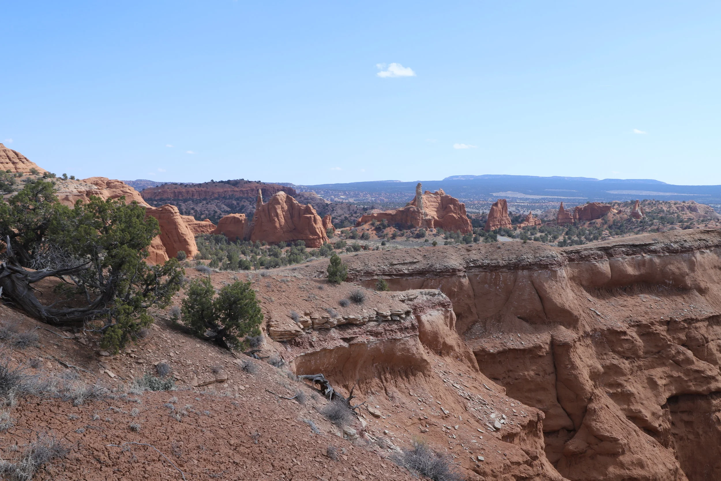
Kodachrome - Angel’s Palace
The Kaiparowits Plateau is in the middle of the monument and shares its norther border with Kodachrome Basin State Park and the Dixie National Forest, and its southern border reaches Glen Canyon National Recreation Area. Cottonwood Canyon Road is a dirt road that cuts through Kaiparowits Plateau and connects the towns of Big Water (UT Hwy 89) and Escalante (UT Hwy 12). Several trailheads start off of Cottonwood Canyon Road. See the below map.

Peekaboo Slot Canyon from the Top
Escalante Canyons is the eastern section of Escalante bordered by Dixie National Forest on the north side, and the Glen Canyon Recreation Area on the east and southern sides. Common trailheads take off from Hole in the Rock Road (another dirt road), UT Hwy 12, and Burr Trail Road.
Use the below map to view popular trailhead locations.
There are Grand Staircase-Escalante Visitor Centers in Big Water, Kanab, Cannonville, and Escalante. As you move around the park, stop in each of these visitor centers to learn the current status of roads and trails. As we were travelling in March, some of the roads and trails were closed due to weather-related causes. The BLM staff was knowledgeable about the roads and trails in their specific region of the monument, but if I asked about another region, they could give road conditions but suggested I stop at the other visitor centers for trail information. It’s a really big park….

Toodstool Hike
One other suggestion that I would make is to buy a hiking guide book in one of the visitor centers to get more detailed information about the hikes and unmarked trailheads. I picked out Hiking the Escalante by Rudi Lambrechtse.
How To Plan A Trip
I planned my entire spring break trip for my first-time using Pinterest, which is an easier way of searching great hiking blogs than through Google. Look through pictures to find the trails you are interested in and then keep notes on how the authors suggest getting to the trailheads. If you find a hike you are interested in, try a new search just for that trail, and cross-check how to get to the trailhead from multiple people. Similarly, ensure multiple people reference similar trail distances. Water is hard to find in the desert. You want to be sure how far you plan to hike so you bring enough water per person. (And then bring extra water, because you never know…)

My 6-year-old is ready for another hike
Trails that I saw frequently referenced in my searches on Pinterest are highlighted in my above google map. We did not have a long enough trip to try them all, and not all are appropriate for children, so make sure to do more research than simply looking at my map.
Escalante – What To Expect In March
As I read through hiker blogs for Escalante, I saw some amazing pictures of trails. However, none of them commented on what time of year they were hiking in Escalante. We hiked in March. This is a time when snow is melting, and so even if it hasn’t rained, roads and trails can still be wet and impassable. Stop at the visitor centers before you head out.

Toadstool
Cottonwood Canyon Road was closed, unfortunately, when we were there. The visitor center in Big Water gave us this information. So, we took Hwy 89 from Page, AZ, to Kanab to Hwy 12 to get into Escalante, UT. We missed out on hiking the Cottonwood Narrows and Grosvenor’s Arch. But we were able to hike the Toadstools, which we would have missed otherwise. In the hot tub that night, we met a family that tried driving down Cottonwood Road. They had not stopped at the Visitor Center. The road was marked “closed” but you can still drive around the sign, which they had. They made it 12 miles into the dirt road, and agreed, it should have been closed. Then they had to backtrack back to the highway. It’s closed for a reason. It’s ok to be disappointed though, but read on for other options.

Long Canyon - Burr Trail Road
There were two other hikes that I wanted to do, but that did not work out in March. One was Willis Creek Slot Canyon. The road to Willis Creek was open, but closed 1.5 miles before the trailhead. This adds 3 miles of walking to the trail. Not a big deal for more senior hikers, but 3 extra miles is a lot to a 6-year-old. We bypassed this trail.
The other trail I really wanted to try was Zebra Slot Canyon. The Big Water Visitor Center did not have information about this trail. The road (Hole in the Rock) was open. We stopped in the Escalante Visitor Center before heading out, and were told the slot canyon was open, but that the water in the slot canyon was still chest high. Another no-go for a 6-year-old. And likely a no-go for most people. Slot canyons are hard enough when you can see the ground. I can’t imagine trying to swim my way through super tiny spots…

Kodachrome - Sentinel Trail
Even with these disappointments, Escalante was voted as the favorite park we visited from both of my boys. Read the next section for the trails that we were able to do.
One other note – it was March, and it was hot. The mornings were cool in the upper 30s, but by mid afternoon the temperatures rose into the 70s. In the dry desert, this was warm, and we drank a lot of water. When we were out to eat at night, we asked the locals when the most popular times to visit were. We were told April-May and Sept-Oct. Neither of these times works if you have kids in school. I would pick Spring Break over visiting these trails in the summer months, even if there’s a chance some of the trails don’t work out due to weather.

Toadstool Hike
And one last thing about traveling in March – the restaurants in Escalante were not consistently open during the week days. We ate at Circle D’s on the weekend – which was a great family restaurant. The only thing we found open to kids under 21 (that wasn’t Subway) was Nemos during the weekdays. But Nemos was great! Just get it to go and eat in the hotel if it’s too cold to eat outside (this is a drive thru location).
If you would like to receive notification of future posts, please sign up below. I will not share your email address information with anyone.
What We Hiked
Toadstool
We started our trip to Escalante from Page, AZ. Our first hike was Toadstool. This was an awesome and easy hike for kids. No scary cliffs, but lots of ups and downs throughout the trail, and it felt like you were on the Moon (or at least someplace not on Earth) when you got to the Toadstools. If you’re a college-age, pre-kids type of adult, I’d skip this hike and favor something longer.

Toadstools
This hike was about 1.5 miles, although you could make it longer if you hiked further into the toadstool section.

Toadstools
The trailhead is easily marked in Google Maps. But on the road, it is just an unmarked pullout. When you are in Kanab or Page and have access to the internet, plug-in “toadstool trailhead” into Google Maps, and you will find it easily. Otherwise, pay attention to your mileage. Coming from Page, AZ, the trailhead was 27.7 miles on Hwy 89 from Lake Powel Blvd.
Shakespeare Arch – Sentinel Trail

Kodachrome - Sentinel Trail
This trail is in Kodachrome State Park. There was a small State Park entrance fee of $8 for a day pass. Kodachrome State Park is off of Hwy 12 on Kodachrome which then turns into Cottonwood Canyon Road. The road is paved until Kodachrome State Park. It then became a dirt road, which was closed.

Kodachrome - Shakespeare Arch
Shakespeare Arch was a 1.7-mile loop hike. If you’ve been to Bryce National Park, Kodachrome has the same feel to it, but no snow, and the hoodoos are much smaller. It feels like a pre-Bryce National Park in a geological time scale. This hike has the only arch in the park.
Angel’s Palace
Kodachrome - Angel’s Palace
This trail is also in Kodachrome State Park. This is a 1.5-mile hike through a canyon and up onto rocks that overlook the park and pier into Bryce Canyon. This was a great hike for kids as there are several rocks to climb on and the viewpoints are amazing. This is primarily an in-and-out hike, but there is a small loop on top to get better surrounding views.

Kodachrome - Angel’s Palace
Peekaboo and Spooky Gulch Slot Canyons

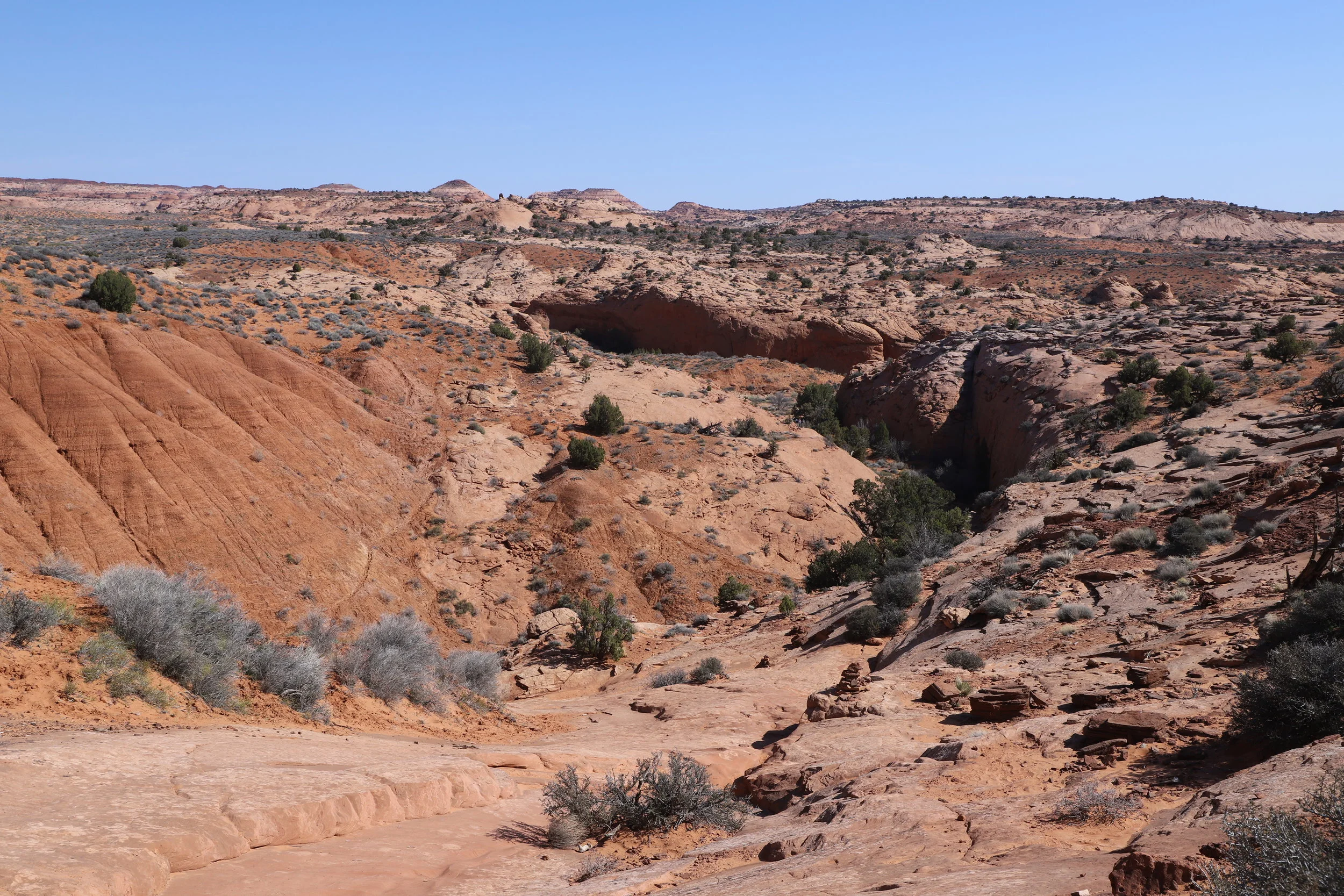
Hiking Peekaboo Slot Canyon
This trail was voted as one of the top 2 trails on Spring Break trip by both of my boys. We hiked for 3.5 miles and 3 hours on these trails, also going into Brimstone Slot Canyon for just about a 100 yards or so (but you could definitely go further). This trailhead is down Hole-in-the-Rock Road approximately 26 miles. The pullout is marked as “Dry Forks”. Note that Hole-in-the Rock is a dirt road. You don’t need 4WD to go down this road, but it helped having it. From the pullout, there are two parking lots. The first is 0.8 miles from the trailhead. The second is right next to the trailhead. If you are planning on going to the closer trailhead, you need 4WD. Even with a Dodge Ram, there were a few points I was worried I was going to tip the truck over. For my 6-year-old, 1.6 miles matters, a lot. And I was really glad to have the truck.
Trail down to Peekaboo, Spooky Gulch, and Brimstone Slot Canyons
There is no bathroom at this trailhead. If you need to stop, stop at Devil’s Garden (about 12 miles down Hole in the Rock). You are in backcountry. Leave your information at the trailhead kiosk and remember to mark that you returned safely. The trail winds down slickrock to the beginning of the slot canyons. The trail is marked with cairns (small rock piles). When you get to the bottom, there are three ways to go. To the left is Brimstone. This is a slot canyon that can be explored but is not a thru canyon. We did this one at that the end. In the middle is Peekaboo. This slot canyon starts with a high climb, that helps if there is an adult at the top pulling everyone else up. Even with this challenging start, this if the way I would recommend going. To the right is Spooky Gulch. There were a few families trying to go this way. It works, but there are some extra challenges if you want to head in this direction.

Entrance into Peekaboo Slot Canyon
We traveled through Peekaboo first. There were only two difficult spots. The first was the immediate climb into the canyon. As I was the only adult with my two children, we took the help of another adult that helped pulls us up into the canyon. A few turns later, was a deep puddle. I was able to help my 6-year-old up past the puddle, but my 10-year-old got pretty wet as did I. I heard from other hikers, to take your socks and shoes off for this portion. This would have been a better idea… We hiked with wet feet.

Peekaboo Slot Canyon
Peekaboo isn’t very challenging beyond this, but there are a lot of fun tight spots where the kids fit through easily and I had to think a few times to figure out how to squeeze through. Peekaboo ends and there is about a 0.5-mile hike until you hit Spooky. Just follow the cairns.

Walking out of Peekaboo Slot Canyon
Spooky had several challenging spots. The first was about a 10-foot drop. There is a ledge to climb down first to and then it’s about a 6-foot drop. I went first. My 6-year-old went second. My older son helped him get to the first ledge, and then he had to jump into my arms. Took some courage, but no tears. My youngest really loved hiking this slot canyon. Last was my 10-year-old. He did it on his own with my supervision. No worries. I did get tired though of the number of adults commenting on how amazing it was that I was doing this hike “on my own.” This wasn’t true. My boys and I helped each other.

Spooky Gulch Slot Canyon
There were two other hard parts in Spooky. One was a sudden drop around a twist. It wasn’t too hard in the direction we were going, we just slid around and down it, but we heard from others this spot going the opposite direction took some effort to get over. The other were some extremely tight spots. I had to take off my backpack and pull it. I picked a direction for my feet and my head, and that was the way I had to stay while I hugged the rocks and squeezed through.

Spooky Gulch spits you back out near the entrance of Peekaboo, forming a nice hiking loop. This hike was hard, but it was fun because of the challenges. And my 6-year-old loved it because he was the “best” at it do to his small size.
Dinosaur Trackway
This isn’t so much a “hike” as it is a place to explore and find dinosaur footprints. To get to Dinosaur Trackway, drive down Hole-in-the-Rock Road about 14 miles from Hwy 12. The sign to look for is called “11 mi Collet”. Take this dirt road about 2.5 miles and there will be a branch off to the right. Take this until you see a small place to park.

Dinosaur Trackway - Climb up onto the sandstone rocks and go all the way up
Climb up onto the sandstone and start exploring. The Sauropod footprints are big round circles, and there are several.

Sauropod Footprints on Dinosaur Trackway
There are also therapod footprints (3 toes) but these are a little harder to see. When we happened to be here, there was a geologist that was exploring the footprints at the same time, and she showed us where they were at, otherwise I wouldn’t have noticed those. (I think a better place to see the three-toed footprints is in Moab –Mill Canyon Dinosaur Trail)
Devil’s Garden

Devil’s Garden
This is another place worth exploring. Again, it’s not so much a “hike” as there are trails crisscrossing all around, so you can pretty much just wander past the rocks and arches. There is a bathroom here, which was fantastic to find after being out on the Hole in the Rock trails most of the day. The Devil’s Garden parking lot is found about 12 miles from Hwy 12.

Devil’s Garden
Lower Calf Creek Falls

Hiking Lower Calf Creek Falls
This hike was one of the more popular hikes we went on in Escalante and is the only one where there was a fee to park. Bring $5 cash or a checkbook. The parking lot was not full when we started, but this was a different story when we left. I would suggest arriving early.

Lower Calf Creek Falls Petroglyphs
This hike is a little more than 3 miles from the parking lot to the waterfall. There is an interpretive guide that you can pick up at a visitor center that makes the 3 miles go a little faster as we were all looking for the next sign post. It is quite a bit cooler next to the waterfall, so bring a light jacket. Also, as this is a longer hike, pack extra water for each person hiking.

Lower Calf Creek Falls
Long Canyon
If you have an extra hour, this is a fun place for kids to climb up onto the rocks. This isn’t really a hike though, and only takes about 15-30 minutes to explore. Take Hwy 12 to Burr Trail Road and travel approximately 11 miles to an unmarked paved pullout for parking. From here, there is a small canyon to explore.

Long Canyon - Despite it’s name, the accessible portion of the slot canyon is not that deep

Long Canyon - The boys loved climbing on the rocks here
Anasazi State Park
This Utah State Park is near Boulder, UT, along Hwy 12. As we had already hiked 6 miles at Lower Calf Creek Falls, I was looking for things to do with the boys that didn’t require much walking. This was a great stop. We watched a short video, learned about how the Anasazi lived and out in the back of the museum are dwellings (both a completed replica and the outline of the original homes).
From Escalante, we made our way up to Capitol Reef National Park along Hwy 12.
More Posts from Nature Impacts Us:


Here’s your guide to a proposed six-day hiking itinerary in Moab, UT, my favorite city to visit in the United States. This agenda is designed for those that love hiking and rock scrambling, and includes trails both within Arches and Canyonlands National Parks as well as the lesser known trails just outside of Moab. I’ve included the difficulty of the trails, distance and elevation stats, as well as potential obstacles that may be tricky if mobility is a concern. At the end of this post, I’ve added some other destinations you may want to include on your Moab road trip, as the downside to visiting Moab is not having a major airport nearby. No worries though, there are many awesome places to explore in Utah to make your entire trip memorable.